
Portage County is a county in the U.S. state of Wisconsin. As of the 2010 census, the population was 70,019. Its county seat is Stevens Point.

The Wisconsin River is a tributary of the Mississippi River in the U.S. state of Wisconsin. At approximately 430 miles (692 km) long, it is the state's longest river. The river's name, first recorded in 1673 by Jacques Marquette as "Meskousing", is rooted in the Algonquian languages used by the area's American Indian tribes, but its original meaning is obscure. French explorers who followed in the wake of Marquette later modified the name to "Ouisconsin", and so it appears on Guillaume de L'Isle's map. This was simplified to "Wisconsin" in the early 19th century before being applied to Wisconsin Territory and finally the state of Wisconsin.
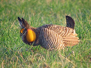
The greater prairie chicken or pinnated grouse, sometimes called a boomer, is a large bird in the grouse family. This North American species was once abundant, but has become extremely rare and extirpated over much of its range due to habitat loss. Conservation measures are underway to ensure the sustainability of existing small populations. One of the most famous aspects of these creatures is the mating ritual called booming.

The Driftless Area is a region in southwestern Wisconsin, southeastern Minnesota, northeastern Iowa, and the extreme northwestern corner of Illinois, of the American Midwest. The region escaped the flattening effects of glaciation during the last ice age and is consequently characterized by steep, forested ridges, deeply carved river valleys, and karst geology characterized by spring-fed waterfalls and cold-water trout streams. Ecologically, the Driftless Area's flora and fauna are more closely related to those of the Great Lakes region and New England than those of the broader Midwest and central Plains regions. Colloquially, the term includes the incised Paleozoic Plateau of southeastern Minnesota and northeastern Iowa. The region includes elevations ranging from 603 to 1,719 feet at Blue Mound State Park, and covers 24,000 square miles (62,200 km2). The rugged terrain is due both to the lack of glacial deposits, or drift, and to the incision of the upper Mississippi River and its tributaries into bedrock.
Frances "Fran" Hamerstrom was an American author, naturalist and ornithologist known for her work with the greater prairie chicken in Wisconsin, and for her research on birds of prey. Hamerstrom was a prolific writer, publishing over 100 professional papers and 10 books on the prairie chicken, harriers, eagles, and other wildlife topics. Some were translated into German.

Horicon Marsh is a marsh located in northern Dodge and southern Fond du Lac counties of Wisconsin. It is the site of both a national and a state wildlife refuge. The silted-up glacial lake is the largest freshwater cattail marsh in the United States.

The Iroquois County State Wildlife Area is an Illinois state park that occupies 2,480 acres (1,004 ha) in northeastern Iroquois County, near the border with Indiana. The nearest municipality is Beaverville, Illinois, and the nearest exit on a limited-access highway is Exit 302 on Interstate 57.

Crex Meadows is a wildlife area that consists of marshes, wetlands, brush prairies, and forests. Crex Meadows is located in near the village of Grantsburg, Wisconsin, in Burnett County, Wisconsin. Its 30,000 acres (120 km2) are home to 270 species of birds and 600 species of plants.

The Dewey Marsh is a state wildlife area in Portage County, Wisconsin, United States.

Coddington is an unincorporated community in the town of Buena Vista in Portage County, Wisconsin, United States.

Pointe Mouillee State Game Area is a state game area in the U.S. state of Michigan. It encompasses 7,483 acres (30.3 km2) of hunting, recreational, and protected wildlife and wetland areas at the mouth of the Huron River at Lake Erie, as well as smaller outlying areas within the Detroit River. Pointe Mouillee State Game Area was established in 1945 and is administered by the Michigan Department of Natural Resources.

The Great Texas Coastal Birding Trail is a state-designated system of trails, bird sanctuaries, and nature preserves along the entire length of the Texas Gulf Coast in the United States. As the state of Texas hosts more bird species than any other state in the U.S. the trail system offers some of the most unusual opportunities for bird-watching in the world. The "trail" is actually 43 separate hiking and driving trails that include 308 birding sites. The sites themselves feature a variety of viewing opportunities with boardwalks, observation decks, and other amenities. The trails boast more than 450 bird species. The trail system is managed by the Texas Parks and Wildlife Department as part of the Great Texas Wildlife Trails which also include the Heart of Texas Wildlife Trail, the Panhandle Plains Wildlife Trail, and the Prairies and Pineywoods Wildlife Trail.

The Blackduck State Forest is a state forest near the town of Blackduck, located in Beltrami and Itasca counties in Minnesota. It is adjacent to the Buena Vista State Forest and the federally managed Chippewa National Forest. It is managed primarily by the Minnesota Department of Natural Resources and the counties.

Moss Landing Wildlife Area is a California State wildlife preserve on the shore of Elkhorn Slough.
Mascoutin Valley State Trail is a rail trail in northeastern Wisconsin. The trail is used for walking, bicycling, horseback riding, and snowmobiling during the winter months. The trail can also be used for cross-country skiing and snowshoeing but the trail is not groomed and must be shared with snowmobiles. Numerous miles of snowmobile trails connect to the Mascoutin Valley State Trail.

Gibraltar Rock State Natural Area is a natural area in southern Wisconsin, United States, which is 68 acres (28 ha) in size, and is located along the 1,000-mile-long (1,600 km) Ice Age Trail.

Theresa Marsh is located near Theresa, Wisconsin, in northern Washington County and eastern Dodge County. The marsh is the starting point for the Rock River, a tributary of the Mississippi River, and the marsh is an important stopping point for migratory birds. The Theresa Marsh Wildlife Area is a 5,990-acre (2,420 ha) state park that includes grassland, cattail, brush marsh, woodlands, agricultural land, seasonally flooded wetlands, and permanent wetlands. There are several campgrounds in the area. The Allenton State Wildlife Area is nearby.
The Prairie Ridge State Natural Area is a 4,101-acre (1,660 ha) collaborative natural area managed by the Illinois Department of Natural Resources. It is managed for the benefit of endangered, threatened, watch list, and area sensitive species associated with the tallgrass prairie habitat of south-central Illinois, especially the greater prairie chicken. The natural area is split between land parcels in Jasper County and Marion County, in the U.S. state of Illinois.
The Sand Prairie-Scrub Oak State Nature Preserve, formerly called the Mason County State Wildlife Refuge and Recreation Area, is a natural area located in the U.S. state of Illinois. Containing 1,460 acres, it is a dedicated state nature preserve. It is located in western Mason County. The nearest town is Kilbourne, Illinois and the nearest numbered highway is Illinois Route 97. It contains fragmentary examples of the ecosystem described in its name.
