Wisconsin Rapids, Wisconsin | |
---|---|
Coordinates: 44°23′12″N89°49′23″W / 44.38667°N 89.82306°W | |
Country | United States |
State | Wisconsin |
County | Wood |
Government | |
• Mayor | Shane Blaser [1] |
Area | |
• Total | 14.77 sq mi (38.25 km2) |
• Land | 13.86 sq mi (35.88 km2) |
• Water | 0.91 sq mi (2.37 km2) |
Elevation | 1,027 ft (313 m) |
Population | |
• Total | 18,877 |
• Density | 1,360.2/sq mi (525.2/km2) |
Time zone | UTC−6 (CST) |
• Summer (DST) | UTC−5 (CDT) |
ZIP Codes | 54494-54495 |
Area code(s) | 715 & 534 |
FIPS code | 55-88200 [4] |
GNIS feature ID | 1576906 [5] |
Website | http://www.wirapids.org |
Wisconsin Rapids is a city in and the county seat of Wood County, Wisconsin, United States. [6] The population was 18,877 at the 2020 census. [3] The city also forms one of the core areas of the United States Census Bureau's Marshfield-Wisconsin Rapids Micropolitan Statistical Area, which includes all of Wood County and had a 2020 population of 74,207. [7]
The American Indians called the area "Ahdawagam", meaning "Two-sided Rapids". Although Europeans began to settle this area in the 1830s, Wisconsin Rapids has been known by this name only since 1920. Prior to that, the community was divided by the Wisconsin River, with the west side incorporated as Centralia and the east side as Grand Rapids. The two cities merged in 1900, with the entire community taking the name Grand Rapids. [8] The name was changed in 1920 to avoid mail and other goods from being misdirected to the other city already named Grand Rapids, Wisconsin in the same county, or to the much better known Grand Rapids, Michigan. [9]
Wisconsin Rapids is located at 44°23′12″N89°49′23″W / 44.38667°N 89.82306°W (44.386805, −89.823078). [10]
According to the United States Census Bureau, the city has a total area of 14.77 square miles (38.3 km2), of which 13.88 square miles (35.9 km2) is land and 0.89 square miles (2.3 km2) is water. [11]
Census | Pop. | Note | %± |
---|---|---|---|
1870 | 1,115 | — | |
1880 | 1,350 | 21.1% | |
1890 | 1,702 | 26.1% | |
1900 | 4,493 | 164.0% | |
1910 | 6,521 | 45.1% | |
1920 | 7,243 | 11.1% | |
1930 | 8,726 | 20.5% | |
1940 | 11,416 | 30.8% | |
1950 | 13,496 | 18.2% | |
1960 | 15,042 | 11.5% | |
1970 | 18,587 | 23.6% | |
1980 | 17,995 | −3.2% | |
1990 | 18,245 | 1.4% | |
2000 | 18,435 | 1.0% | |
2010 | 18,367 | −0.4% | |
2020 | 18,877 | 2.8% | |
U.S. Decennial Census [12] |
As of the census of 2020, [3] the population was 18,877. The population density was 1,360.2 inhabitants per square mile (525.2/km2). There were 9,265 housing units at an average density of 667.6 per square mile (257.8/km2). The racial makeup of the city was 87.4% White, 3.5% Asian, 1.4% Black or African American, 0.9% Native American, 1.5% from other races, and 5.3% from two or more races. Ethnically, the population was 4.6% Hispanic or Latino of any race.
As of the 2010 census, there were 18,367 people, 8,296 households, and 4,626 families living in the city. The population density was 1,329.0 inhabitants per square mile (513.1/km2). There were 8,972 housing units at an average density of 649.2 per square mile (250.7/km2). The racial makeup of the city was 92.2% White, 0.7% African American, 1.0% Native American, 3.7% Asian, 0.9% from other races, and 1.5% from two or more races. Hispanic or Latino of any race were 2.9% of the population. [13]
There were 8,296 households, of which 27.1% had children under the age of 18 living with them, 39.1% were married couples living together, 11.9% had a female householder with no husband present, 4.8% had a male householder with no wife present, and 44.2% were non-families. 38.7% of all households were made up of individuals, and 16.8% had someone living alone who was 65 years of age or older. The average household size was 2.17 and the average family size was 2.87.
The median age in the city was 41.1 years. 22.8% of residents were under the age of 18; 8.5% were between the ages of 18 and 24; 23.3% were from 25 to 44; 25.5% were from 45 to 64; and 19.8% were 65 years of age or older. The gender makeup of the city was 47.8% male and 52.2% female.
As of the census [4] of 2000, there were 18,435 people, 7,970 households, and 4,782 families living in the city. The population density was 1,390 people per square mile (536.8/km2). There were 8,426 housing units at an average density of 635.3 per square mile (245.3/km2). The racial makeup of the city was 94.04% White, 0.34% African American, 0.80% Native American, 3.46% Asian, 0.02% Pacific Islander, 0.37% from other races, and 0.97% from two or more races. Hispanic or Latino of any race were 1.31% of the population.
There were 7,970 households, out of which 28.0% had children under the age of 18 living with them, 46.0% were married couples living together, 10.6% had a female householder with no husband present, and 40.0% were non-families. 34.8% of all households were made up of individuals, and 16.0% had someone living alone who was 65 years of age or older. The average household size was 2.26 and the average family size was 2.93.
In the city, the population was spread out, with 24.7% under the age of 18, 8.5% from 18 to 24, 27.5% from 25 to 44, 19.8% from 45 to 64, and 19.4% who were 65 years of age or older. The median age was 38 years. For every 100 females, there were 90.1 males. For every 100 females age 18 and over, there were 86.2 males.
The median income for a household in the city was $34,956, and the median income for a family was $43,594. Males had a median income of $36,098 versus $22,466 for females. The per capita income for the city was $17,723. About 7.0% of families and 9.1% of the population were below the poverty line, including 12.5% of those under age 18 and 7.2% of those age 65 or over.
Known for its papermaking history, Wisconsin Rapids is also an important location for the cranberry industry. Wisconsin Rapids is the corporate home of the international educational software company, Renaissance Learning. [14]
From its founding in 1894, Wisconsin Rapids was home to the corporate headquarters of Consolidated Papers, Inc, which was acquired by the Finnish company Stora Enso in early-2000. [15] In 2007, NewPage acquired the paper production facility. [16] In 2015, Verso Corporation acquired the mill. [17] Verso continues its presence in the area with a paper mill that houses two paper machines and a kraft pulp mill. In June 2020, Verso announced the closing of their paper mill for at least two months, with the resulting loss of 900 jobs. [18] After being closed for 2 years, Billerud (also known as BillerudKorsnäs) acquired with Verso in 2022. [19] Since the closing in 2020, the only use of the property has been a lease with Sonoco, another paper manufacturer, which operates in a secondary building of the plant. [20]
The South Wood County Airport (IATA: ISW, ICAO: KISW, FAA LID: ISW), also known as Alexander Field, is a public use airport located one nautical mile (1.85 km) south of the central business district of Wisconsin Rapids. Dial-a-ride transit services are provided by River City Cab.
Wisconsin Rapids is served by Wisconsin Rapids Public Schools. Lincoln High School is the local public high school, serving grades 9 through 12. Assumption High School is a private Catholic high school. River Cities High School is an alternative to the local high schools. The city has two middle schools, Wisconsin Rapids Area Middle School (grades 6–8) and Central Oaks (Virtual) Academy (6–8). East Junior High was a junior high school for grades 8–9 before it closed after the 2017–2018 school year. [21]
Good Shepherd Lutheran School [22] (1–8th grade) and St. Paul's Lutheran School [23] (3K–8th grade) are two grade schools of the Wisconsin Evangelical Lutheran Synod in Wisconsin Rapids.
Mid-State Technical College, which has a campus in the city, offers vocational diplomas, and Lakeland University offers qualifications in academic subjects.
McMillan Memorial Library serves Wisconsin Rapids and southern Wood County. McMillan was a Finalist for the 2019 National Medal for Museum and Library Service.
Although this is a list of radio stations based in the Wisconsin Rapids area, the signals of radio stations from much of Central Wisconsin are commonly received in the city.
Wisconsin Rapids has several local parks, including Robinson Park, Gaynor Park, and Lyon Park. There is also a skate park. The state water-skiing championships are held at Lake Wazeecha every year and the national BMX Bandit cycling championships are held at the Central Wisconsin BMX velodrome.
The Wisconsin Rapids Aquatic Center opened in July 2020 and features several pools and other recreational facilities including a tennis court, pickleball courts, an adventure playground, ice-skating rink, and splash pad.
There are three museums, the South Wood County Historical Corporation Museum, the Alexander House, and the Wisconsin River Paper Making Museum, all of which are housed in historical family homes.
The Wisconsin Rapids Riverkings are a hockey team who is a member of the United States Premier Hockey League and won the Midwest Elite Championship in the 2016–2017 season. The Riverkings currently play their home games at the South Wood County Recreation Center.
The Wisconsin Rapids Rafters are a collegiate summer baseball team formed in 2010 who are a member of the Northwoods League. The Rafters won the league championship in 2016. They currently play their home games at Witter Field.
The state cross country running championships are held in Wisconsin Rapids annually, as are the state (and sometimes national) water skiing tournaments.
The Alexander House is a museum to the history of the Nekoosa Edwards Paper Company (NEPCO), and also hosts art exhibitions. The building is the former home of the Alexander Family, which ran the Nekoosa Edwards Paper Company.
The South Wood County Historical Corporation Museum houses multiple exhibits covering the history of the South Wood County area. The building is the former Witter family home, Shadowlawn.
There is a municipal zoo which is free to enter, and operated during the summer only.
There is a prairie chicken sanctuary at the Buena Vista Wildlife Reservation, and every year the Prairie Chicken Festival is held.
The Souper Snow Sculpture Spectacular that takes place every February is one of the largest snow sculpture competitions in the country by numbers of sculptures.
The FRM Music Festival happens every June, as does the Cranberry Blossom Festival. The Grand Affair Arts Festival takes place in September of each year (2020 excepted, due to COVID-19 precautions).
Wood County is a county located in the U.S. state of Wisconsin. As of the 2020 census, the population was 74,207. Its county seat is Wisconsin Rapids. The county is named after Joseph Wood, a member of the Wisconsin State Assembly. Wood County comprises the Wisconsin Rapids-Marshfield, WI Micropolitan Statistical Area and is included in the Wausau-Stevens Point-Wisconsin Rapids, WI Combined Statistical Area.
Marathon County is a county located in the U.S. state of Wisconsin. As of the 2020 census, the population was 138,013. Marathon County's seat is Wausau. It was founded in 1850, created from a portion of Portage County. At that time the county stretched to the northern border with the upper Michigan peninsula. It is named after the battlefield at Marathon, Greece.
Lincoln County is a county located in the U.S. state of Wisconsin. As of the 2020 census, the population was 28,415. Its county seat is Merrill. The county was created in 1875 and named after President Abraham Lincoln.
Stevens Point is the county seat of Portage County, Wisconsin, United States. The city was incorporated in 1858.
Grand Rapids is a city in Itasca County, Minnesota, United States, and it is the county seat. The population was 11,126 at the 2020 census. The city is named for the 3.5-mile (5.6 km) long rapids in the Mississippi River which was the uppermost limit of practical steamboat travel during the late 19th century. Today the rapids are hidden below the dam of UPM Paper Company.
Sauk Rapids is a city in Benton County, Minnesota, United States. The population was 13,862 at the 2020 census and is 13,896 according to 2021 census estimates, about a third of Benton County's population. It is on a set of rapids on the Mississippi River near its confluence with the Sauk River.
Park Rapids is a city in and the county seat of Hubbard County, Minnesota, United States. It is near Itasca State Park, the source of the Mississippi River, as well as the beginning of the Heartland State Trail. The city was founded in 1890 near the Fish Hook River rapids and is along U.S. Highway 71 and Minnesota State Highway 34. The population was 4,142 at the 2020 census.
Rhinelander is a city in and the county seat of Oneida County, Wisconsin, United States. The population was 8,285 at the 2020 census.
The Town of Harmony is a town located in Rock County, Wisconsin, United States. The population was 2,569 at the 2020 census. The city of Janesville is adjacent to the town.
Clintonville is a city in Waupaca County, Wisconsin, United States. The population was 4,591 at the 2020 census. The area that became Clintonville was first settled in March, 1855.
Biron is a village in Wood County, Wisconsin, United States. The population was 839 at the 2010 census. It is the site of ND Paper's Biron Mill.
Nekoosa is a city in Wood County, Wisconsin, United States. Its name derives from the Ho-Chunk word, "Nįįkuusra", "Nakrusa", or "Nįkusara" which translates to "running water". The population was 2,580 at the 2010 census.
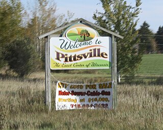
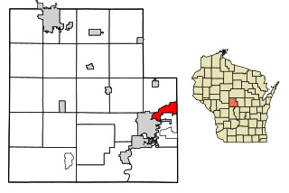
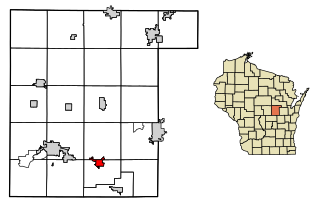
Pittsville is a city in Wood County, Wisconsin, United States. The population was 874 at the 2010 census.
Marshfield is in Wood and Marathon counties in the state of Wisconsin. It is located at the intersection of U.S. Highway 10, Highway 13 and Highway 97. The largest city in Wood County, its population was 18,929 at the 2020 census. Of this, 18,119 were in Wood County, and 810 were in Marathon County. The city is part of the United States Census Bureau's Marshfield-Wisconsin Rapids Micropolitan Statistical Area, which includes all of Wood County. The portion of the city in Marathon County is part of the Wausau Metropolitan Statistical Area.
Sartell is a city in Benton and Stearns Counties in the U.S. state of Minnesota that straddles the Mississippi River. It is part of the St. Cloud Metropolitan Statistical Area. The population was 19,351 at the 2020 census, making it St. Cloud's most populous suburb and the fourth-largest city in central Minnesota, after St. Cloud, Elk River, and Willmar.
Menasha is a city in Calumet and Winnebago counties in the U.S. state of Wisconsin. The population was 18,268 at the 2020 census. Of this, 15,144 were in Winnebago County, and 2,209 were in Calumet County. The city is located mostly in Winnebago County; only a small portion is in the Town of Harrison in Calumet County. Doty Island is located partially in Menasha. The city's name comes from the Winnebago word meaning "thorn" or "island". In the Menominee language, it is known as Menāēhsaeh, meaning "little island".
Mosinee is a city in Marathon County, Wisconsin. It is part of the Wausau, Wisconsin Metropolitan Statistical Area. The population was 4,452 at the time of the 2020 census.
Montello is a city in and the county seat of Marquette County, Wisconsin, United States. The population was 1,495 at the 2010 census. The Fox River flows through the city. Montello is home to the largest tree in Wisconsin. A notable attraction in the city is the former granite quarry, which has been transformed into a park with several waterfalls.
Baraboo is a city in the Midwest and the county seat of Sauk County, Wisconsin, United States. The largest city in the county, Baraboo is the principal city of the Baraboo Micropolitan Statistical Area which comprises a portion of the Madison Combined Statistical area. Its 2020 population was 12,556. It is situated on the Baraboo River.
Weyauwega is a city in Waupaca County, Wisconsin, United States. The population was 1,900 at the 2010 census. The city is located mostly within the Town of Weyauwega, though it is politically independent of the town. Small portions extend north into the adjacent Town of Royalton. The city is commonly referred to as "Wega" by local residents. The name "Weyauwega" is described by the Weyauwega Chamber of Commerce as potentially meaning "Here we rest" in a local indigenous language because the town's origin was a stopping/resting point between two rivers when Native Americans had to portage their canoes. Given the local indigenous culture is described as Menominee the language may be the Menominee language if this etymology for Weyauwega is correct.