Park Avenue (Manhasset, New York)

Last updated
Park Avenue
Maintained by Town of North Hempstead (Manhasset portion), Village of Munsey Park (Munsey Park portion)
East end Plandome Road
West endDead-end just southeast of Park Avenue North
Park Avenue in Munsey Park, looking west on September 6, 2021. Park Avenue, Munsey Park, Long Island, New York September 6, 2021 A.jpg
Park Avenue in Munsey Park, looking west on September 6, 2021.

Park Avenue is a road in Manhasset and Munsey Park in the Town of North Hempstead, in Nassau County, on Long Island, in New York, United States. It serves as a through street between Plandome Road and Port Washington Boulevard (NY 101).

Contents

Description

Park Avenue runs east-west through the hamlet of Manhasset and the Village of Munsey Park; it serves as the main west-east route through the Manhasset Park subdivision of Manhasset and of the Village of Munsey Park. [1] [2] [3] [4] [5] [6] Its western terminus is at Plandome Road across from the Manhasset Long Island Rail Road station, and its eastern terminus is at a dead-end towards the southeastern corner of Munsey Park. [1]

The first section to be built was the portion in the Manhasset Park subdivision of the hamlet of Manhasset, which was platted out ca. 1912. [7] During this time, Park Avenue ended at Locust Place (now Munsey Place). [7]

When the Metropolitan Museum of Art had Munsey Park developed in the 1920s, Park Avenue was extended through the new development to Northern Boulevard (NY 25A) and Port Washington Boulevard (NY 101) at the southeastern corner of the village. It was planned to be one of the only through streets within the village so as to keep the character of the new community residential. [2] [3] [5] [6] The original landscaping along Park Avenue through Munsey Park, which was (and still is) tree-lined, was designed by the Olmsted Brothers. [4] [5]

When the short-lived Munsey Park Golf Club was operating in the easternmost parts of Munsey Park between 1932 and 1937, Park Avenue traversed it. [8]

The portion of Park Avenue located within the unincorporated hamlet of Manhasset is owned and maintained by the Town of North Hempstead. [9] The part of the road located within the Incorporated Village of Munsey Park is owned and maintained by Munsey Park. [9]

Former segments

Originally, Park Avenue branched at its southeast end, with one branch leading to Port Washington Boulevard (NY 101) and the other leading to Northern Boulevard (NY 25A). [8] These connections were eventually severed, causing the road to dead-end just southeast of Park Avenue North; the area was redeveloped as a shopping center. [1] [2]

Park Avenue North

Park Avenue North
Park Avenue
South/west endPark Avenue
North/east end Port Washington Boulevard

Park Avenue North is a northeastern spur of Park Avenue, running between Park Avenue and Port Washington Boulevard (NY 101) to the northeast. [1] It is often considered to be part of Park Avenue, as apparent on official Maps. [9]

Park Avenue North is maintained by the Village of Munsey Park. [9]

See also

Related Research Articles

<span class="mw-page-title-main">Flower Hill, New York</span> Village in New York, United States

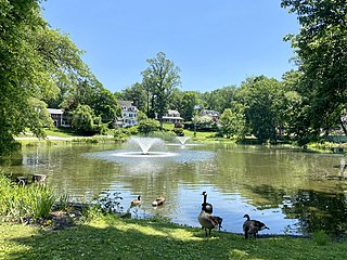
Flower Hill is a village in Nassau County, on the North Shore of Long Island, in New York, United States. The eastern half is considered part of the Greater Roslyn area, which is anchored by the Incorporated Village of Roslyn. Western and northern parts are more closely associated with Manhasset and Port Washington. The population was 4,794 at the time of the 2020 census.

<span class="mw-page-title-main">Manhasset, New York</span> Hamlet and census-designated place in New York, United States

Manhasset is a hamlet and census-designated place (CDP) in Nassau County, on the North Shore of Long Island, in New York, United States. It is considered the anchor community of the Greater Manhasset area. The population was 8,176 at the 2020 census.

<span class="mw-page-title-main">Munsey Park, New York</span> Village in New York, United States

Munsey Park is a village in Nassau County, on the North Shore of Long Island, in New York, United States. It is considered part of the Greater Manhasset area, which is anchored by Manhasset. The population was 2,809 at the 2020 census.

<span class="mw-page-title-main">North Hempstead, New York</span> Town in New York, United States

North Hempstead is one of three towns in Nassau County, on Long Island, in New York, United States. The population was 237,639 at the 2020 census.

<span class="mw-page-title-main">Port Washington, New York</span> Hamlet and census-designated place in North Hempstead, Nassau County, New York, United States

Port Washington is a hamlet and census-designated place (CDP) on the Cow Neck Peninsula in the Town of North Hempstead, in Nassau County, on the North Shore of Long Island, in New York. The hamlet is the anchor community of the Greater Port Washington area. The population was 16,753 at the 2020 census.

<span class="mw-page-title-main">Roslyn Estates, New York</span> Village in New York, United States

Roslyn Estates is a village in the Town of North Hempstead in Nassau County, on the North Shore of Long Island, in New York, United States. It is considered part of the Greater Roslyn area, which is anchored by the Incorporated Village of Roslyn. The population was 1,318 at the 2020 census.

<span class="mw-page-title-main">New York State Route 25A</span> Queens-Calverton highway on Long Island

New York State Route 25A (NY 25A) is a state highway on Long Island in New York, United States. It serves as the main east–west route for most of the North Shore of Long Island, running for 73 miles (117 km) from Interstate 495 (I-495) at the Queens–Midtown Tunnel in the New York City borough of Queens to NY 25 in Calverton, Suffolk County. The highway is a northern alternate route of NY 25, which follows a more inland routing along Jericho Turnpike.

<span class="mw-page-title-main">New York State Route 101</span> State highway in Nassau County, New York, United States

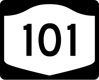
New York State Route 101 (NY 101) is a 3.58-mile (5.76 km) long state highway in northwestern Nassau County, New York, in the United States. It runs north–south as Port Washington Boulevard from NY 25A in Flower Hill, west of Roslyn and east of Manhasset, to Astor Lane in Sands Point. It becomes County Route 101 (CR 101) south along Searingtown Road to Shelter Rock Road (CR 8) and becomes Middle Neck Road north of Astor Lane, continuing north and west to a dead end at the Long Island Sound as the unsigned County Route D55 (CR D55).

<span class="mw-page-title-main">Hempstead Harbor</span> Bay on north coast of Long Island, New York

Hempstead Harbor is a bay hugging the northern coast of Long Island, New York. Located off of the Long Island Sound, it forms the northernmost portion of the political border between the Nassau County towns of Oyster Bay on the east and North Hempstead on the west, as well as the western border of the city of Glen Cove.

<span class="mw-page-title-main">County Route 8 (Nassau County, New York)</span>

Nassau County Route 8 is an unsigned county road in Nassau County, New York. It travels between Old Country Road and Rockaway Avenue in Garden City and Northern Boulevard in Manhasset.

<span class="mw-page-title-main">County Route 15 (Nassau County, New York)</span>

Nassau County Route 15 is a 4.02-mile, unsigned county road in Nassau County, New York. It travels between Port Washington Boulevard in Port Washington at its north end and Old Northern Boulevard in the Village of Roslyn at its southern end. A small portion also passes through the Village of Flower Hill.

<span class="mw-page-title-main">Strathmore, New York</span> Hamlet in New York, United States

Strathmore is an unincorporated, Levitt & Sons-developed hamlet in the Town of North Hempstead in Nassau County, on the North Shore of Long Island, in New York, United States, within the census-designated place (CDP) of Manhasset.

<span class="mw-page-title-main">Manhasset Park District</span>

The Manhasset Park District is a park district serving much of the Greater Manhasset area of Nassau County, Long Island, New York, United States. It is headquartered a 62 Manhasset Avenue, Manhasset, NY 11030.

<span class="mw-page-title-main">Leeds Pond</span>

Leeds Pond is a natural pond in Plandome Manor, in Nassau County, on Long Island, in New York, United States.

<span class="mw-page-title-main">Manhasset Valley Park</span>

Manhasset Valley Park is a park in Manhasset, on Long Island, in New York, United States. It is operated by the Town of North Hempstead.

<span class="mw-page-title-main">Port Washington to Great Neck Overhead Transmission Project</span>

The Port Washington to Great Neck Overhead Transmission Project was a 2014 electrical transmission line project in the Town of North Hempstead in Nassau County, on Long Island, in New York, United States. It saw the construction of a new power transmission line between Great Neck and Port Washington.

The Manhasset–Lakeville Water District (MLVWD) is a public water utility district serving a large portion of Nassau County, on Long Island, in New York, United States.

<span class="mw-page-title-main">Stonytown Road</span>

Stonytown Road is a 1.32-mile road in the incorporated villages of Flower Hill, Plandome, and Plandome Manor in the Town of North Hempstead, in Nassau County, on the North Shore of Long Island, in New York, United States. It serves as a major east-west through street across the Cow Neck Peninsula, between Plandome Road and North Plandome Road to the west and Port Washington Boulevard to the east – as well as forming portions of municipal boundaries.

<span class="mw-page-title-main">Plandome Road</span>

Plandome Road is a road in Manhasset and the incorporated villages of Plandome, Plandome Heights, and Plandome Manor in the Town of North Hempstead, in Nassau County, on the North Shore of Long Island, in New York, United States. It serves as a major north–south through street across the west side of the Cow Neck Peninsula, between Northern Boulevard to the south and Stonytown Road and North Plandome Road to the north, and is the main thoroughfare in downtown Manhasset.

<span class="mw-page-title-main">Manhasset Woods Road</span> Road in Nassau County, New York.

Manhasset Woods Road is a 1.16-mile (1.87 km) road in the incorporated villages of Flower Hill and Munsey Park in the Town of North Hempstead, in Nassau County, on the North Shore of Long Island, in New York, United States. It serves as a major north–south through street across the lower portion of the Cow Neck Peninsula, between Northern Boulevard to the south and Stonytown Road to the north.

References

  1. 1 2 3 4 "Long Island Index: Interactive Map". www.longislandindexmaps.org. Retrieved 2021-08-22.
  2. 1 2 3 "Village History". Munsey Park. Retrieved 2021-08-22.
  3. 1 2 Mackay, Robert B. (2015). Gardens of Eden: Long Island's Early Twentieth-Century Planned Communities. W. W. Norton & Company. ISBN   978-0393733211.
  4. 1 2 Olmsted Archives, Frederick Law Olmsted NHS, NPS (2014-09-03), photo album 07434-01-ph001 , retrieved 2021-08-22{{citation}}: CS1 maint: multiple names: authors list (link)
  5. 1 2 3 Senate Committee on Foreign Relations Subcommittee on Terrorism, Narcotics, and International Communications, United States Congress (1927). Drugs, Law Enforcement, and Foreign Policy: The Cartel, Haiti, and Central America. U.S. Government Printing Office. pp. 366–367.{{cite book}}: CS1 maint: multiple names: authors list (link)
  6. 1 2 Murray, Anthony (2019-05-06). "Striking Gold: A look at the expansive history of Munsey Park". Manhasset Press. Retrieved 2021-08-22.
  7. 1 2 Map: Map of Manhasset Park, Town of North Hempstead (Map). November 1912 – via Nassau County Public Records.
  8. 1 2 "1932 property ownership map of Roslyn, Roslyn Harbor, Glenwood Landing, East Hills, Greenvale & Roslyn Heights | News | Roslyn Landmark Society". www.roslynlandmarks.org. Retrieved 2021-08-22.
  9. 1 2 3 4 "Nassau County Road Jurisdiction Viewer". nassau-county.maps.arcgis.com. Retrieved 2021-08-22.