
Metropolitan Manila, commonly shortened to Metro Manila and formally the National Capital Region, is the capital region and largest metropolitan area of the Philippines. Located on the eastern shore of Manila Bay, the region lies between the Central Luzon and Calabarzon regions. Encompassing an area of 636.00 km2 (245.56 sq mi) and with a population of 13,484,462 as of 2020, it consists of sixteen highly urbanized cities: Manila—the capital city—Caloocan, Las Piñas, Makati, Malabon, Mandaluyong, Marikina, Muntinlupa, Navotas, Parañaque, Pasay, Pasig, Quezon City, San Juan, Taguig, and Valenzuela, along with one independent municipality, Pateros. As the second most populous and the most densely populated region in the Philippines, it ranks as the 9th most populous metropolitan area in Asia and the 6th most populous urban area in the world.

Makati, officially the City of Makati, is a highly urbanized city in the National Capital Region of the Philippines, known for being one of the leading financial centers in the country. As of 2013, the city has the highest concentration of multinational and local corporations in the Philippines. Major banks, corporations, department stores as well as foreign embassies are based in Makati. Makati is also known for being a major cultural and entertainment hub in Metro Manila. According to the 2020 census, it had a population of 629,616 people, making it the 47th most populous city in the country and 8th most populous in Metro Manila. Makati is one of the most densely populated city proper areas globally, ranking 8th worldwide and 2nd in the Philippines, after Manila, with a population density of 28,975 inhabitants per square kilometer.

The Pasig River is a water body in the Philippines that connects Laguna de Bay to Manila Bay. Stretching for 25.2 kilometers (15.7 mi), it bisects the Philippine capital of Manila and its surrounding urban area into northern and southern halves. Its major tributaries are the Marikina River and San Juan River. The total drainage basin of the Pasig River, including the basin of Laguna de Bay, covers 4,678 square kilometers (1,806 sq mi).

Pasig, officially the City of Pasig, is a highly urbanized city in the National Capital Region of the Philippines. According to the 2020 census, it has a population of 803,159 people.

The South Luzon Expressway (SLEX), signed as E2 of the Philippine expressway network and R-3 of the Metro Manila arterial road network, is a controlled-access highway that connects Metro Manila to the provinces in the Calabarzon, Mimaropa and Bicol Region on the island of Luzon in the Philippines. The expressway has a length of 49.56 km, traveling from its northern terminus at the Magallanes Interchange in Makati to its southern terminus at Santo Tomas, Batangas, connecting it to the Southern Tagalog Arterial Road. A portion of the expressway from the Magallanes Interchange to the Calamba Exit is part of Asian Highway 26 of the Asian highway network. It will be the longest expressway in the Philippines starting with the completion of Toll Road 4 surpassing the Subic–Clark–Tarlac Expressway (SCTEX) as well as providing a gateway to Visayas upon the completion of Toll Road 5.

Bonifacio Global City is a central business district and major financial hub located in Taguig, Metro Manila, Philippines. It is located 11 kilometers (6.8 mi) southeast of the capital city of Manila. The district experienced commercial growth following the sale of a 440 ha military base at Fort Bonifacio by the Bases Conversion and Development Authority (BCDA). The entire district used to be the part of the main Philippine Army camp.

Ayala Malls Trinoma is a large shopping mall in Quezon City, Philippines, owned by property development firm Ayala Land. Opened on May 16, 2007, the mall is located on the east side of Epifanio de los Santos Avenue in Quezon City, giving significant market competition to the nearby SM North EDSA as one of the largest malls in Metro Manila. It is also one of two malls that will be serving Ayala Land's Vertis North township, which is located beside the mall, along with a new lifestyle block mall Ayala Malls Vertis North, similar to Greenbelt in Makati, which was also developed by Ayala Malls.
The Marikina–Infanta Highway is a 117.5-kilometer (73.0 mi) highway that connects Quezon City, Metro Manila with Infanta, Quezon in the Philippines.

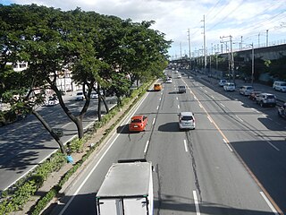
Circumferential Road 5 (C-5), informally known as the C-5 Road, is a network of roads and bridges which comprise the fifth beltway of Metro Manila in the Philippines. Spanning some 43.87 kilometers (27.26 mi), it connects the cities of Las Piñas, Parañaque, Pasay, Pasig, Quezon City, Taguig, and Valenzuela.

Ayala Malls is a retail subsidiary of real estate company Ayala Land, an affiliate of Ayala Corporation. Founded in 1988, Ayala Malls owns a chain of large shopping malls, all located in the Philippines. Ayala Malls is one of the largest shopping mall retailer in the Philippines, along with SM Supermalls and Robinsons Malls.

The U.P.–Ayala Land TechnoHub is an information technology hub jointly developed by the University of the Philippines Diliman and property developer Ayala Land. It is located along Commonwealth Avenue in U.P. Campus, Quezon City, Metro Manila. and occupies 20 ha (0.20 km2) of the 37.5 ha (0.375 km2) U.P. North Science and Technology Park inside the U.P. Diliman campus.

The following is an alphabetical list of articles related to the Philippine capital region of Metro Manila.
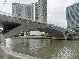
The Estrella–Pantaleon Bridge, also known as the Rockwell Bridge, is a four-lane box girder bridge crossing the Pasig River in Metro Manila, Philippines. It connects Estrella Street in Makati on the south bank of the Pasig River to Pantaleon Street via Barangka Drive in Mandaluyong on the north bank, near the site of the Acqua Private Residences.
Granada Street is a road in Quezon City, Metro Manila, Philippines. It runs from Nicanor Domingo Street, as an extension of Gilmore Avenue, to the boundary with San Juan, where it terminates at Bonny Serrano Avenue and becomes Ortigas Avenue. The street is sometimes considered part of Ortigas Avenue by motorists.

Vertis North is a mixed-use development in Quezon City, Metro Manila, Philippines. It is a joint venture project between Ayala Land Inc. (ALI) and the National Housing Authority (NHA). Like the Makati Central Business District, it has a mix of residential developments and open spaces.

Circulo Verde is a mixed-use development in Quezon City, Metro Manila, the Philippines. It is a primarily residential enclave on a meander of the Marikina River in the village of Bagumbayan on Quezon City's border with Pasig. The 12.47-hectare (30.8-acre) riverfront community is a redevelopment of the former cement plant owned by Concrete Aggregates Corp., a subsidiary of Ortigas & Company. It is one of the four major estates owned and developed by the company in Metro Manila, which in 2019 maintained a combined land bank of 50 hectares across the Eastern Manila cities of Mandaluyong, Pasig and Quezon City.

Parklinks is a 35-hectare (86-acre) mixed-use development that straddles the Pasig–Quezon City boundaries in the Philippines. It is a joint project of LT Group and Ayala Land located on the banks of the Marikina River in the eastern part of Metro Manila. The riverfront development is the biggest along the segment of C-5 Road north of the Pasig River and is planned to contain a 3-hectare (7.4-acre) central urban park, an esplanade, river terrace, riparian gardens and bike trails designed to make it one of the greenest urban estates in the Manila metropolitan area.

Bridgetowne is a real estate development spanning the border of Pasig and Quezon City in Metro Manila, Philippines. It is a mixed township and business park situated in a former industrial area on both banks of the Marikina River near the junction of Eulogio Rodriguez Jr. Avenue and Ortigas Avenue. The 30.61-hectare (75.6-acre) masterplanned community is the first integrated township project by Robinsons Land Corporation, the real estate arm of JG Summit. It is currently anchored by four office towers in its information technology park dedicated to the business process outsourcing sector, its second in Metro Manila after Robinsons Cybergate in Mandaluyong. Once completed, the township will be a community consisting of seven office towers, a shopping mall, five-star hotel and residential condominiums, with a landmark bridge and a light art installation called The Victor as its centerpiece.

Cycling is a popular mode of transport and recreational sport in the Philippines. Bicycles were first introduced to the archipelago in the 1880s during the Spanish colonial occupation of the Philippines and served as a common mode of transport, especially among the local mestizo population.


