
The Brahmaputra, also known as the Yarlung Tsangpo in Tibet, the Siang/Dihang River in Arunachal Pradesh, and Luit, Dilao in Assam, is a trans-boundary river which flows through Tibet, India, and Bangladesh. It is the 9th largest river in the world by discharge, and the 15th longest.

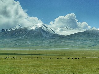
The geography of Tibet consists of the high mountains, lakes and rivers lying between Central, East and South Asia. Traditionally, Western sources have regarded Tibet as being in Central Asia, though today's maps show a trend toward considering all of modern China, including Tibet, to be part of East Asia. Tibet is often called "the roof of the world," comprising tablelands averaging over 4,950 metres above the sea with peaks at 6,000 to 7,500 m, including Mount Everest, on the border with Nepal.

The Yarlung Tsangpo Grand Canyon, also known as the Yarlung Zangbo Grand Canyon, the Tsangpo Canyon, the Brahmaputra Canyon or the Tsangpo Gorge, is a canyon along the Yarlung Tsangpo River in Tibet Autonomous Region, China. It is the deepest canyon in the world, and at 504.6 kilometres (313.5 mi) is slightly longer than the Grand Canyon in the United States, making it one of the world's largest. The Yarlung Tsangpo originates near Mount Kailash and runs east for about 1,700 kilometres (1,100 mi), draining a northern section of the Himalayas before it enters the gorge just downstream of Pei, Tibet, near the settlement of Zhibe. The canyon has a length of about 240 kilometres (150 mi) as the gorge bends around Mount Namcha Barwa and cuts its way through the eastern Himalayan range. Its waters drop from about 2,900 metres (9,500 ft) near Pei to about 1,500 metres (4,900 ft) at the end of the Upper Gorge where the Po Tsangpo River enters. The river continues through the Lower Gorge to the Indian border at an elevation of 660 metres (2,170 ft). The river then enters Arunachal Pradesh and eventually becomes the Brahmaputra.

Qüxü County, or Qushui or Chushur or Chushul, is a county in the Lhasa southwest of the main center of Chengguan, Tibet, China. It is mountainous in the northwest, flatter near the Lhasa River, which runs through the east of the county, and the Yarlung Tsangpo, which forms the southern border. The population as of 2000 was 29,690, mostly engaged in agriculture or animal husbandry. The county is home to the Nyethang Drolma Lhakhang Temple.

The Friendship Highway is an 800-kilometre (500 mi) scenic route connecting the capital of Tibet, Lhasa, with the Chinese/Nepalese border at the Sino-Nepal Friendship Bridge between Zhangmu and Kodari. It includes the westernmost part of China National Highway 318 (Shanghai-Zhangmu) and crosses three passes over 5,000 m (16,400 ft) before dropping to 1,750 m (5,700 ft) at the border.

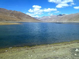
Lake Paiku is a lake at 4,591 meters (15,062 ft) elevation on the Tibetan Plateau at 28°55′N85°35′E, 18 kilometers (11 mi) south of the Yarlung Tsangpo (Brahmaputra) River. The lake is 27 kilometers (17 mi) long and 6 kilometers (3.7 mi) wide at its narrowest. It is surrounded by mountains reaching 5,700 to 6,000 meters. Streams fed by glaciers cascade to the valley floor, but most sink into alluvial deposits before reaching the lake.
The Nyenchen Tanglha Mountains are a 700-kilometre (430 mi) long mountain range, and subrange of the Transhimalaya System, located in Tibet and the Tibet Autonomous Region of China.

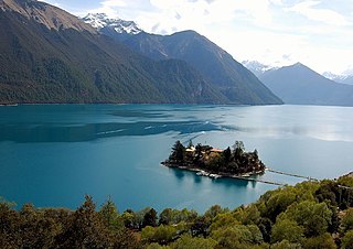
Gongbo'gyamda County is a county of Nyingchi City in the Tibet Autonomous Region, lying approximately 275 km (171 mi) east of Lhasa at its central point. Its main geographical feature is Basum Tso, a green lake about 3,700 m (12,100 ft) above sea level.

Zhanang County or Dranang County, is a county of Shannan (Lhokha) in the Tibet Autonomous Region. The capital town of county is Dratang town, with a monastery named Dratang.
Nagarzê County is a county of Shannan located in the south-east of the Tibet Autonomous Region. The Yarlung Tsangpo river dominates the county. Baidi Township is located in the county.

The Nyang River is a major river in south-west Tibet and the second largest tributary of the Yarlung Tsangpo River by discharge.

The Yarlung Tsangpo, also called Yarlung Zangbo is the upper stream of the Brahmaputra River located in the Tibet Autonomous Region, China. It is the longest river of Tibet and the fifth longest in China.

The following outline is provided as an overview of and topical guide to Tibet:

The Lhasa River, also called Kyi Chu, is a northern tributary of the Yarlung Tsangpo River in the south of the Tibet Autonomous Region of China. The Yarlung Tsangpo is the upper section of the Brahmaputra River. The Lhasa River is subject to flooding with the summer monsoon rains, and structures have been built to control the floods. In its lower reaches the river valley is an important agricultural area. The city of Lhasa, named after the river, lies on the river. There are two large hydroelectric power stations on the river, the Zhikong Hydro Power Station (100 MW) and the Pangduo Hydro Power Station (160 MW)
The Northeastern Himalayan subalpine conifer forests are a temperate coniferous forests ecoregion of the middle to upper elevations of the eastern Himalayas and southeast Tibetan Plateau. The ecoregion occurs in southeastern Tibet Autonomous Region, China, in northern and eastern Arunachal Pradesh, India, and extreme eastern Bhutan.
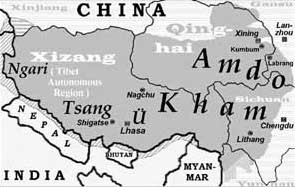
Ü is a geographic division and a historical region in Tibet. Together with Tsang, it forms Central Tibet Ü-Tsang, which is one of the three Tibetan regions or cholka. The other two cholka are Kham (Dotod) and Amdo (Domed). According to a Tibetan saying, "the best religion comes from Ü-Tsang, the best men from Kham, and the best horses from Amdo".
The Yamdrok Hydropower Station, also known as the Yamdrok Yumtso or Yamzhog Yumcog hydropower station, is a hydroelectric power station just north of Yamdrok Lake, about 16 km (9.9 mi) southwest of Qüxü. The power station is in the Lhoka (Shannan) Prefecture of the Tibet Autonomous Region, China. Opposition to using the lake, considered holy, delayed construction at first. The project ran into difficulties and was two years late, completed in 1998.

The Nimu Maqu River is a left tributary of the Yarlung Tsangpo River that flows south through Nyêmo County in Lhasa Municipality, Tibet, China.
The Bailey–Morshead exploration of the Tsangpo Gorge was an unauthorised expedition by Frederick Bailey and Henry Morshead in 1913 which for the first time established the definite route by which the Tsangpo River reaches the sea from north of Himalaya, through the Tsangpo Gorge.

The Yiong Tsangpo is a right-bank tributary of the Parlung Tsangpo in eastern Tibet Autonomous Region of China. It starts in the Nyenchen Tanglha Mountains of central Lhari County, runs 286 kilometres and empties into the Parlung Tsangpo near Tongmai of Bomê County. A tremendous Yigong landslide occurred on the Yiong Tsangpo in Bomê County on April 9, 2000. It can be called the largest and longest rapid landslide in China.

