
The River Parrett flows through the counties of Dorset and Somerset in South West England, from its source in the Thorney Mills springs in the hills around Chedington in Dorset. Flowing northwest through Somerset and the Somerset Levels to its mouth at Burnham-on-Sea, into the Bridgwater Bay nature reserve on the Bristol Channel, the Parrett and its tributaries drain an area of 660 square miles (1,700 km2) – about 50 per cent of Somerset's land area, with a population of 300,000.

Nether Stowey is a large village in Somerset, South West England. It sits in the foothills of the Quantock Hills, just below Over Stowey. The parish of Nether Stowey covers approximately 4 km2, with a population of 1,373.
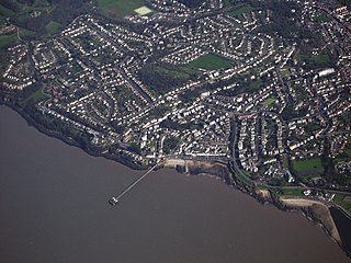
Clevedon is a seaside town and civil parish in the unitary authority of North Somerset, England. It recorded a parish population of 21,281 in the United Kingdom Census 2011, estimated at 21,442 in 2019. It lies along the Severn Estuary, among small hills that include Church Hill, Wain's Hill, Dial Hill, Strawberry Hill, Castle Hill, Hangstone Hill and Court Hill, a Site of Special Scientific Interest with overlaid Pleistocene deposits. It features in the Domesday Book of 1086. Clevedon grew in the Victorian period as a seaside resort.

The Darent is a Kentish tributary of the River Thames and takes the waters of the River Cray as a tributary in the tidal portion of the Darent near Crayford. 'Darenth' is frequently found in the spelling of the river's name in older books and maps, Bartholomew's "Canal's and River of England" being one example. Bartholomew's Gazetteer (1954) demonstrates that Darent means "clear water", a result of it springing from and running through chalk. The purity of the water was a major factor in the development of paper and pharmaceuticals in the area.

Martock is a large village and civil parish in Somerset, England, situated on the edge of the Somerset Levels 7 miles (11.3 km) north west of Yeovil in the South Somerset district. The parish includes Hurst, approximately one mile south of the village, and Bower Hinton, which is located at the western end of the village and bounded by Hurst and the A303. Martock has a population of 4,766 and was historically a market town.

Claverton Pumping Station in the village of Claverton, in the English county of Somerset, pumps water from the River Avon to the Kennet and Avon Canal using power from the flow of the river. It is a Grade I listed building, having been upgraded from Grade II in 2019.

Freshford is a village and civil parish in the Avon valley 6 miles (10 km) south-east of Bath, in the county of Somerset, England. The parish has a population of 551. It is in the Cotswolds Area of Outstanding Natural Beauty (AONB), within the Green Belt and is in a conservation area.

Dunster Working Watermill is a restored 18th century watermill, situated on the River Avill, close to Gallox Bridge, in the grounds of Dunster Castle in Dunster, Somerset, England. It is a Grade II* listed building and within the Grade II* registered parkland of the castle.

Williton railway station in Williton, Somerset, England, was opened by the West Somerset Railway in 1862 and closed by British Rail in 1971. It was reopened in 1976 as a heritage line. The locomotive workshops here are the headquarters of the Diesel and Electric Preservation Group (DEPG).

The Warehouse in Great Bow Yard Langport, Somerset, England is an example of Victorian industrial architecture.

There are 100 Grade I listed buildings in Bristol, England according to Bristol City Council. The register includes many structures which for convenience are grouped together in the list below.
There are 212 Grade II* listed buildings in Bristol, England.

South Petherton is a large village and civil parish in the South Somerset district of Somerset, England, located 5 miles (8 km) east of Ilminster and 5 miles (8 km) north of Crewkerne. The parish had a population of 3,737 in 2021 and includes the smaller village of Over Stratton and the hamlets of Compton Durville, Drayton, Wigborough and Yeabridge. The River Parrett forms the eastern boundary of the parish. The village is approximately 2 miles (3 km) from East Lambrook, Martock and Lopen.

The Grade I listed buildings in Somerset, England, demonstrate the history and diversity of its architecture. The ceremonial county of Somerset consists of a non-metropolitan county, administered by Somerset County Council, which is divided into five districts, and two unitary authorities. The districts of Somerset are West Somerset, South Somerset, Taunton Deane, Mendip and Sedgemoor. The two administratively independent unitary authorities, which were established on 1 April 1996 following the breakup of the county of Avon, are North Somerset and Bath and North East Somerset. These unitary authorities include areas that were once part of Somerset before the creation of Avon in 1974.

Castle Street in Bridgwater, Somerset, England was built in the 1720s, on a site previously occupied by Bridgwater Castle, by Benjamin Holloway or Fort and Shepherd, the Duke's London surveyors for James Brydges, 1st Duke of Chandos. It was originally called Chandos Street. Many of the buildings have been designated as Grade I Listed buildings.

There are 72 Grade II* listed buildings in the city of Brighton and Hove, England. The city, on the English Channel coast approximately 52 miles (84 km) south of London, was formed as a unitary authority in 1997 by the merger of the neighbouring towns of Brighton and Hove. Queen Elizabeth II granted city status in 2000.
The Bishops Lydeard Mill and Rural Life Museum is a historic building and museum in Bishops Lydeard, Somerset, England.

Tucking Mill is a small hamlet within the parish of Monkton Combe, Somerset, England. It lies on Midford Brook and was a key point on the now disused Somerset Coal Canal.

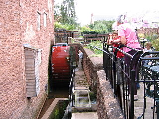
The Land Yeo is a small river which flows through North Somerset, England. It rises on Dundry Hill and supplies Barrow Gurney Reservoirs before flowing through various villages to Clevedon where it drains into the Severn Estuary. During the past 1,000 years it has powered at least ten watermills, however only one is still functional. Since 2003 initiatives have been undertaken to clean up the river, improving water quality and encouraging wildlife.

