Nakthan Village on the Parvati valleyRudra-Nag waterfall – the sacred and spiritual siteTunda Bhuj village (3285m) has this beautiful and open meadowThakur Kuan village (3560m) – a wire bridge crossing the Parvati RiverPandupul natural rock bridge
The precipitous valley road climbs past a side valley leading to the village of Malana near the famous tourist spot Kasol. From here, the road passes through the Sikh and Hindu pilgrimage town of Manikaran and terminates at Pulga, where the construction of the Parvati Hydel Project, a hydroelectric dam, dominates the landscape. From Pulga, the footpath climbs to a temple and small dhaba at Rudra-Nag waterfall, apparently after its resemblance of a water snake. Beyond Rudra-Nag waterfall, the trail ascends further through thick pine forests to the spiritual site of Kheerganga where Shiva is said to have meditated for 3000 years. The hot springs at Kheerganga are extremely important for Hindu and Sikh pilgrims as well as many others who believe the waters have sacred healing properties.[1]
From Kheerganga to the site of Tunda Bhuj village (3285m) the Parvati Valley cuts a steep-sided gorge through the mountains and as the altitude increases, the thick, coniferous forest gradually makes way for patches of meadowland scattered with boulders.[2][1] Several tributaries join the main Parvati River and numerous waterfalls cascade down the steep valley sides. Beyond Tunda Bhuj, the conifers continue only as far as the Basuki Nal tributary but groves of silver birch continue to line the valley, quickly becoming sparse as the altitude increases.[2][1]
At Thakur Kuan village (3560m), the Parvati Valley meets the valley of Dibibokri Nal river which is a tributary of Parvati River, which climbs towards the Northeast to the Dibibokri Glacier and Dibibokri Pyramid mountain peak (6400m). The area is characterised by abundant alpine flowers and rocky outcrops glittering with mica. Beyond Thakur Kuan village, the Parvati Valley ascends gradually to Pandupul village (Pandu Pul) where two natural, rock bridges cross the Parvati River and a southern tributary. According to legend, these bridges were created by the massive strength of the Pandava brothers.[2]
From Pandupul, the wide valley of the upper Parvati valley climbs gradually through the wide, high-altitude meadowland of Odi Thatch to the sacred site of Mantalai Lake (4100m), the source of the Parvati River. Continuing east from Mantalai lake, it is possible to cross the Pin Parvati Pass (5319m) into the Pin Valley National Park and on to the Mudh village in the Lahul and Spiti district of Himachal Pradesh.[2]
Parvati Valley's scenic trekking routes are a popular destination for trekkers and tourists.
Disappearances
According to journalist Harley Rustad’s 2022 non-fiction book Lost in the Valley of Death: Obsession and Danger in the Himalayas,[3] dozens of tourists have mysteriously disappeared in the Parvati Valley.[4]
As Rustad writes "...the Parvati Valley has earned its own nicknames: the Valley of shadows, the Valley of Death. It is a place where every movement exists on a knife edge, where a wrong turn tips a vehicle over an unbarriered cliff edge, a wrong step pitches a traveler into the churning maelstrom of the river, a wrong turn sends a hiker to ranges unknown. Since the early 1990s, dozens of international backpackers have vanished without a trace while traveling in and around the Parvati Valley, an average of one every year, earning this tiny, remote sliver of the subcontinent a dark reputation as India's backpacker Bermuda Triangle. Though the circumstances of each disappearance are different—the tourist's country of origin; villages visited or paths walked; last known location—yet eerily similar. All feature a spirited backpacker seeking an off-the-beaten-track adventure, a collection of anecdotes from fellow travelers relating the backpacker's final days, a family's anguished search, and thousands of unanswered questions."
Some of the high-profile disappearances include 2016's Justin Shetler of the United States,[5] 2015's Bruno Muschalik of Poland,[6] 2000's disappearance of Alexei Ivanov,[7] 1999's Maarten de Bruijn of Rotterdam,[8] 1997's Ardavan Taherzadeh of Canada,[9] 1996's Ian Mogford of Britain,[10] and 1992's disappearance of Odette Houghton of Australia and Marianne Heer of Switzerland.[11] In July 2000, months after Alexei Ivanov's disappearance, two German backpackers — Jorge Weihrauch and Adrian Mayer-Tasch — were shot as they slept in their tents; Jorge was killed while Adrian escaped with 4 shotgun wounds to the leg. One month later, British civil engineer, Martin Young, his Spanish girlfriend, Maria Girones, and her son, Cristobal, were beaten while they slept in their tent with only Martin surviving. Roughly a year later, a skeleton wrapped in its sleeping bag was identified as a missing Israeli military pilot, Nadav Mintzer, whose passport had quietly been offered for sale in the markets of Manali.[8] A 1998 article from The Tribune reported that 33 foreigners had died between 1991 and 1998 in the Kulu district.[12]
Gallery
The upper Parvati Valley
A view of Parvati River from the Kasol Town with the Mighty Himalayas in the vicinity
Parvati valley at Kasol
View of Parvati Valley
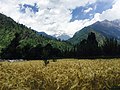
Wheat cultivation at Pulga village
The waters can be freezing even during the early summer and only near a hot spring do the locals take baths
This page is based on this Wikipedia article Text is available under the CC BY-SA 4.0 license; additional terms may apply. Images, videos and audio are available under their respective licenses.