
Pawnee National Grassland is a United States National Grassland located in northeastern Colorado on the Colorado Eastern Plains. The grassland is located in the South Platte River basin in remote northern and extreme northeastern Weld County between Greeley and Sterling. It comprises two parcels totaling 193,060 acres (78,130 ha) largely between State Highway 14 and the Wyoming border. The larger eastern parcel lies adjacent to the borders of both Nebraska and Wyoming. It is administered in conjunction with the Arapaho-Roosevelt National Forest from the U.S. Forest Service office in Fort Collins, with a local ranger district office in Greeley.
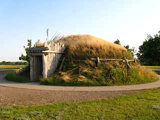
The Knife River Indian Villages National Historic Site, which was established in 1974, preserves the historic and archaeological remnants of bands of Hidatsa, Northern Plains Indians, in North Dakota. This area was a major trading and agricultural area. Three villages were known to occupy the Knife area. In general, these three villages are known as Hidatsa villages. Broken down, the individual villages are Awatixa Xi'e, Awatixa and Big Hidatsa village. Awatixa Xi'e is believed to be the oldest village of the three. The Big Hidatsa village was established around 1600.
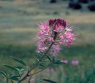
Cleomella serrulata, commonly known as Rocky Mountain beeplant/beeweed, stinking-clover, bee spider-flower, skunk weed, Navajo spinach, and guaco, is a species of annual plant in the genus Cleomella. Many species of insects are attracted to it, especially bees, which helps in the pollination of nearby plants. It is native to southern Canada and the western and central United States. The plant has often been used for food, to make dyes for paint, and as a treatment in traditional medicine.

The black-tailed prairie dog is a rodent of the family Sciuridae found in the Great Plains of North America from about the United States–Canada border to the United States–Mexico border. Unlike some other prairie dogs, these animals do not truly hibernate. The black-tailed prairie dog can be seen above ground in midwinter. A black-tailed prairie dog town in Texas was reported to cover 25,000 sq mi (64,000 km2) and included 400,000,000 individuals. Prior to habitat destruction, the species may have been the most abundant prairie dog in central North America. It was one of two prairie dogs described by the Lewis and Clark Expedition in the journals and diaries of their expedition.

Bouteloua dactyloides, commonly known as buffalograss or buffalo grass, is a North American prairie grass native to Canada, Mexico, and the United States. It is a short grass found mainly on the High Plains and is co-dominant with blue grama over most of the shortgrass prairie. Buffalo grass in North America is not the same species of grass commonly known as "buffalo" in Australia.

Agropyron cristatum, the crested wheat grass, crested wheatgrass, fairway crested wheat grass, is a species in the family Poaceae. This plant is often used as forage and erosion control. It is well known as a widespread introduced species on the prairies of the United States and Canada.
Agropyron desertorum is a plant species in the family Poaceae which was originally from Russian and Siberian steppes until it was introduced to the United States from there between 1907 and 1913. Prior to its introduction it was believed that Desert wheatgrass and crested wheatgrass are different species. Currently it can still be found in Central and Western United States, except for Idaho, Kansas, Louisiana, Minnesota, Oklahoma, and Washington.

Puccinia coronata is a plant pathogen and causal agent of oat and barley crown rust. The pathogen occurs worldwide, infecting both wild and cultivated oats. Crown rust poses a threat to barley production, because the first infections in barley occur early in the season from local inoculum. Crown rusts have evolved many different physiological races within different species in response to host resistance. Each pathogenic race can attack a specific line of plants within the species typical host. For example, there are over 290 races of P. coronata. Crops with resistant phenotypes are often released, but within a few years virulent races have arisen and P. coronata can infect them.

South Dakota is a state located in the north-central United States. It is usually considered to be in the Midwestern region of the country. The state can generally be divided into three geographic regions: eastern South Dakota, western South Dakota, and the Black Hills. Eastern South Dakota is lower in elevation and higher in precipitation than the western part of the state, and the Black Hills are a low, isolated mountain group in the southwestern corner of the state. Smaller sub-regions in the state include the Coteau des Prairies, Missouri Coteau, James River Valley, and the Dissected Till Plains. Geologic formations in South Dakota range in age from two billion-year-old Precambrian granite in the Black Hills to glacial till deposited over the last few million years. South Dakota is the 17th-largest state in the country.

Pseudoroegneria spicata is a species of perennial bunchgrass known by the common name bluebunch wheatgrass. It is native to western North America.
Thinopyrum intermedium, known commonly as intermediate wheatgrass, is a sod-forming perennial grass in the Triticeae tribe of Pooideae native to Europe and Western Asia. It is part of a group of plants commonly called wheatgrasses because of the similarity of their seed heads or ears to common wheat. However, wheatgrasses generally are perennial, while wheat is an annual. It has gained the Royal Horticultural Society's Award of Garden Merit as an ornamental.

Selaginella densa is a species of spikemoss known by the common names lesser spikemoss, prairie spikemoss, and Rocky Mountains spikemoss. It is native to western North America, where it can be found from Alaska to Ontario, the Dakotas, Texas and far northern California.

Carex inops is a species of sedge known as long-stolon sedge and western oak sedge. It is native to northern North America, where it occurs throughout the southern half of Canada and the western and central United States.

Elymus lanceolatus is a species of grass known by the common names thickspike wheatgrass and streamside wheatgrass. It is native to North America, where it is widespread and abundant in much of Canada and the western and central United States. There are two subspecies, subsp. lanceolatus occurring throughout the species' range and subsp. psammophilus occurring in the Great Lakes region.

Muhlenbergia cuspidata is a species of grass known by the common name plains muhly. It is native to North America where it is distributed across central Canada and the central United States.

Elymus wawawaiensis is a species of grass known by the common name Snake River wheatgrass. It is native to western North America, where it occurs in the Pacific Northwest. It is native to eastern Washington and Oregon and parts of Idaho.

Asclepias uncialis is a species of flowering plant in the dogbane family known by the common name wheel milkweed. It is native to the western United States. Two subspecies are sometimes described, with ssp. ruthiae containing three plants which are sometimes described as separate species, Asclepias ruthiae, A. eastwoodiana, and A. sanjuanensis.

The Canadian Aspen Forests and Parklands is one of 844 terrestrial ecoregions defined by One Earth. This ecoregion includes parts of the Canadian provinces of Alberta, Saskatchewan, and Manitoba, north-central and eastern North Dakota, most of east South Dakota, and north-central Nebraska in the American Great Plains. The United States Environmental Protection Agency (EPA) defines this ecoregion as the Northern Glaciated Plains.

Arthur's Rock is a 6,780 foot pillar in the foothills of the Colorado Front Range, near Fort Collins, Colorado.
