The Gate of Europe towers, also known as KIO Towers, are twin office buildings near the Plaza de Castilla in Madrid, Spain. The towers have a height of 114 m (374 ft) and have 26 floors. They were constructed from 1989 to 1996. The Puerta de Europa is the second tallest twin towers in Spain after the Torres de Santa Cruz in Santa Cruz de Tenerife.

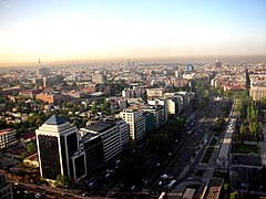
The Paseo del Prado is one of the main boulevards in Madrid, Spain. It runs north–south between the Plaza de Cibeles and the Plaza del Emperador Carlos V, with the Plaza de Cánovas del Castillo lying approximately in the middle. The Paseo del Prado forms the southern end of the city's central axis. It enjoys the status of Bien de Interés Cultural (BIC), and as part of a combined UNESCO World Heritage Site with Buen Retiro Park.

San Sebastián de los Reyes is a municipality in the Community of Madrid, Spain. Founded in 1492, it is located 20 kilometres (12 mi) north of Madrid.
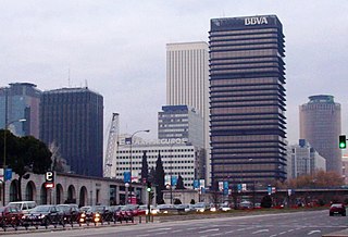
AZCA, an acronym for Asociación Mixta de Compensación de la Manzana A de la Zona Comercial de la Avenida del Generalísimo, is a financial district in Madrid, Spain. The business district, which is located on the northern edge of the city centre, serves as one of the two main financial districts of the Madrid metropolitan area.

Salamanca is one of the 21 districts that form the city of Madrid, Spain. Salamanca is located to the northeast of the historical center of Madrid. Salamanca lies east of the district of Chamberí, south of Chamartín, and north of Retiro. Salamanca counts approximately 151.000 inhabitants.

Paseo de Recoletos is a wide boulevard in central Madrid leading from Plaza de Cibeles to Plaza de Colón.

The Cuatro Torres Business Area (CTBA), also known as the Área de Negocios de las Cuatro Torres, is a business district located in the Paseo de la Castellana in Madrid, Spain, on the former Ciudad Deportiva of Real Madrid. The area contains the four tallest skyscrapers in Spain, and four of the ten tallest in the European Union: the Torre Emperador, Torre de Cristal, Torre PwC and Torre Cepsa. Construction of the buildings finished in 2008.

Plaza Las Delicias is the main plaza in the city of Ponce, Puerto Rico. The square is notable for its fountains and for the various monuments it contains. The historic Parque de Bombas and Ponce Cathedral buildings are located within the plaza, which actually consists of two squares: Plaza Muñoz Rivera on the north end, and Plaza Degetau on the southern end. The square is the center of the Ponce Historic Zone, and it is flanked by the historic Ponce City Hall to the south, the early 19th-century Teatro Fox Delicias to the north, the NRHP-listed Banco Crédito y Ahorro Ponceño and Banco de Ponce buildings to the east, and the Armstrong-Poventud Residence to the west. The square dates back to the early Spanish settlement in Ponce of 1670. It is the main tourist attraction of the city, receiving about a quarter of a million visitors per year.

Plaza del Emperador Carlos V is a square in the city of Madrid. It is named after Charles V, Holy Roman Emperor, who also reigned in Spain as Charles I. However, it is referred to as Plaza de Atocha, because it is where Madrid Atocha railway station is located.

Plaza Muñoz Rivera, formally Plaza Luis Muñoz Rivera, is the smaller of the two plazas at Plaza Las Delicias in the city of Ponce, Puerto Rico. It is located on the north side of Plaza Las Delicias, north of the larger southern Plaza Degetau. The square is notable for its fountains and for the Luis Muñoz Rivera statue. The historic Parque de Bombas and Ponce Cathedral buildings are located immediately to the south of Plaza Muñoz Rivera. The square is at the center of the Ponce Historic Zone, and is flanked by the Armstrong-Poventud Residence to the west, the Teatro Fox Delicias to the north, and Catholic University of Puerto Rico School of Architecture to the east. The square dates back to the early Spanish settlement in Ponce of 1670. It is the main tourist attraction of the city, receiving about a quarter of a million visitors per year.

The Plaza de Castilla is a roundabout in the north of Madrid, Spain.
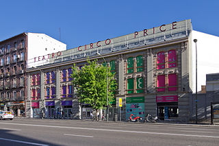
The Circo Price, also known as El Price, is a 2,142-seat concert venue and former circus in Madrid.

The architecture of Madrid has preserved the look and feel of many of its historic neighbourhoods and streets, even though Madrid possesses a modern infrastructure. Its landmarks include the Royal Palace of Madrid, the Royal Theatre with its restored 1850 Opera House, the Buen Retiro Park, the 19th-century National Library building containing some of Spain's historical archives, a large number of national museums, and the Golden Triangle of Art located along the Paseo del Prado and comprising three art museums: Prado Museum, the Reina Sofía Museum, and the Thyssen-Bornemisza Museum, which completes the shortcomings of the other two museums. Cibeles Palace and Fountain have become the monument symbol of the city.

The Palacio de Xifré is a Madrilenian palace now disappeared that was in the Paseo del Prado, at the corner Calle de Lope de Vega, opposite the Prado Museum. It was one of the best examples of Neo-Mudéjar architecture in Madrid and one of the palaces that the Spanish financial elite of the second half of the 19th century had built along the paseos del Prado, Recoletos and la Castellana.

El Viso is a neighborhood of Madrid, part of the Chamartín District. Consisting mainly of residential detached houses, it is currently the wealthiest neighborhood of the Spanish capital, overtaking the Salamanca District. Aristocrats, businessmen, politicians and diplomats have inhabited this area for half a century. The neighborhood also hosts the main headquarters of the Spanish National Research Council (CSIC).

Cuatro Caminos is an administrative neighborhood of Madrid belonging to the district of Tetuán. It has an area of 1.193509 km2 (0.460816 sq mi). As of 1 February 2020, it has a population of 35,395. It was created as slum of the north of the city, on the east side of the Road of France, currently the calle de Bravo Murillo.

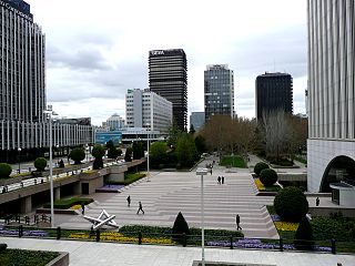
Nuevos Ministerios is a government complex in central Madrid, Spain. The complex houses several government departments: Development, Labour, Social Security, and Ecological Transition. It is located in the block delimited by the Paseo de la Castellana, the Raimundo Fernández Villaverde street, Agustín de Betancourt street and the San Juan de la Cruz square.
The plaza de Pablo Ruiz Picasso is a public square located in Madrid, Spain. It lies at the centre of the AZCA financial district.

The calle de Bravo Murillo is a major street in Madrid, Spain.

The Calle de Génova is a street in Madrid, Spain. It is the dividing line between the neighbourhoods of Justicia and Almagro, in the respective districts of Centro and Chamberí. It runs from the Plaza de Alonso Martínez to the Plaza de Colón.