
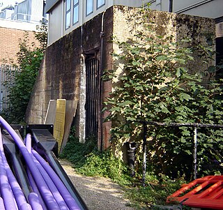
Pear Tree House was the former Civil Defence control centre for South-East London. It is a block of council flats in the Central Hill Estate of Upper Norwood with eight two-bedroom flats and the control centre in the basement.
Pear Tree House was the former Civil Defence control centre for South-East London. It is a block of council flats in the Central Hill Estate of Upper Norwood with eight two-bedroom flats and the control centre in the basement.
In the early 1960s the Metropolitan Borough of Lambeth was grouped with the neighbouring boroughs of Southwark and Camberwell to make up civil defence region 53a. Negotiations took place between them for a site to build a control centre for the area during the heightened atmosphere in the era of the Cuban Missile Crisis. A large area of Gipsy Hill in Lambeth was designated for a new housing estate and, as it was in the extreme south of the borough and well protected by the local hills, a site at the junction of Lunham Road and Hawke Road in SE19 was chosen.
Whilst the two-storey bunker was being designed and approved the structures of civil defence and London government were changing. Work on Pear Tree House started in 1963, but it was now merely going to be a borough control centre; the existing borough control in St Matthews Road, Brixton was to become a sub-control. It cost £31,850 of which the Home Office paid 75% (£23,250). The 18-room bunker and flats were completed in 1966 and the bunker went into care and maintenance when civil defence was stood down two years later.
In 1971 London was designated a civil defence region again and in 1973 the GLC set up emergency planning teams looking at the future structures of civil defence in the capital. It was decided that London would be split into five groups of boroughs each having its own control centre. The GLC selected the Pear Tree House bunker as the South East group war HQ and although not ideal it was converted in 1979.
Because of its location Pear Tree House received a lot of attention in the 1980s. It was a focus of local CND marches, its blast doors were fly posted and it was open to the public for a week in 1982 for CND's Hard Luck campaign which coincided with the dates of the cancelled Hard Rock exercise. Speakers during that week included Duncan Campbell and Bruce Kent.
In the late 1980s the arrangement to rent the bunker from Lambeth expired and 'nuclear-free' Lambeth threatened the London Fire and Civil Defence Authority with eviction. Another site was looked for but an agreement was made and it remained the South East group emergency centre until 1993. It was later used as a social services store and is now empty.

The London Borough of Southwark in south London forms part of Inner London and is connected by bridges across the River Thames to the City of London and London Borough of Tower Hamlets. It was created in 1965 when three smaller council areas amalgamated under the London Government Act 1963. All districts of the area are within the London postal district. It is governed by Southwark London Borough Council.

Crystal Palace is an area in south London, England, named after the Crystal Palace Exhibition building, which stood in the area from 1854 until it was destroyed by fire in 1936. Approximately 7 miles (11 km) south-east of Charing Cross, it includes one of the highest points in London, at 367 feet (112 m), offering views over the capital. The area has no defined boundaries and straddles five London boroughs and three postal districts, although there is a Crystal Palace electoral ward and Crystal Palace Park in the London Borough of Bromley. It forms a part of the greater area known as Upper Norwood, and is contiguous with the areas of Anerley, Dulwich Wood, Gipsy Hill, Penge, South Norwood and Sydenham.

Harold Hill is a suburban area in the London Borough of Havering, East London. 16.6 miles (26.7 km) northeast of Charing Cross. It is a district centre in the London Plan. The name refers to Harold Godwinson who held the manor of Havering-atte-Bower. It is peripheral to London, forming an eastern edge of the urban sprawl.

Britwell is a residential housing estate and civil parish in the north west of Slough, Berkshire, in the south of England. It is about 23 miles west of Charing Cross, London.
West Norwood is a largely residential area of south London within the London Borough of Lambeth, located 5.4 miles (8.7 km) south south-east of Charing Cross. The centre of West Norwood sits in a bowl surrounded by hillsides on its east, west and south sides. From many parts of the area, distant views can be seen, of places such as the City of London, Canary Wharf and Crystal Palace.

Clapham Park is an area in the Borough of Lambeth in London, to the south of central Clapham and west of Brixton.
During the Cold War every London Borough was obliged to have a Civil Defence centre. These were controversial structures as it was widely believed that planning for the aftermath of nuclear war was both expensive and pointless.

Lambeth was a civil parish and metropolitan borough in south London, England. It was an ancient parish in the county of Surrey. The parish was included in the area of responsibility of the Metropolitan Board of Works in 1855 and became part of the County of London in 1889. The parish of Lambeth became a metropolitan borough in 1900, following the London Government Act 1899, with the parish vestry replaced by a borough council.

The Holly Lodge Estate is an estate in Highgate, London.

RAF Uxbridge was a Royal Air Force (RAF) station in Uxbridge, within the London Borough of Hillingdon, occupying a 44.6-hectare (110-acre) site that originally belonged to the Hillingdon House estate. The British Government purchased the estate in 1915, three years before the founding of the RAF. Until the outbreak of the Second World War in 1939, the station was open to the public.

RAF Daws Hill was a Ministry of Defence site, located near High Wycombe and Flackwell Heath, in Buckinghamshire, England, close to the M40 motorway.
New Eltham is an area of south east London, in the London Boroughs of Greenwich and Bexley. It lies south east of Eltham and north west of Sidcup.
Streatham is a constituency represented in the House of Commons of the UK Parliament since 2019 by Bell Ribeiro-Addy of the Labour Party.

Gipsy Hill in south London is a hilly neighbourhood spanning the southern parts of the London Boroughs of Lambeth and Southwark characterised for its great views of the City of London and Dulwich.
The Hyde Farm Estate is a residential area situated in Balham, a district of south London, in the United Kingdom. Unlike the rest of Balham, it is wholly within the London Borough of Lambeth. Its boundaries are: to the south Emmanuel Road; to the east: Radbourne Road; to the north: Hydethorpe Road; and to the west: Cavendish Road.

Loughborough Junction is an area of South London, in the London Borough of Lambeth, which is located equidistant between Brixton, Camberwell, Herne Hill and Dulwich.

The Kelvedon Hatch Secret Nuclear Bunker at Kelvedon Hatch, in the Borough of Brentwood in the English county of Essex, is a large underground bunker maintained during the Cold War as a potential regional government headquarters. Since being decommissioned in 1992, the bunker has been open to the public as a tourist attraction, with a museum focusing on its Cold War history.

South Quay Estate is a mid-rise residential development of around 300 properties adjoining St Katharine Docks in the London Borough of Tower Hamlets. The Estate was built by the Greater London Council as a form of social housing, with the first residents moving in between 1979 and 1981. South Quay Estate includes the Burr Close, Nightingale House, St Anthony's Close and St Katharines Way developments.

The Brixton murals are a series of murals by local artists in the Brixton area, in London. Most of the murals were funded by Lambeth London Borough Council and the Greater London Council after the Brixton riots in 1981.

The Hayward Gallery is an art gallery within the Southbank Centre in central London, England and part of an area of major arts venues on the South Bank of the River Thames. It is sited adjacent to the other Southbank Centre buildings and also the National Theatre and BFI Southbank repertory cinema. Following a rebranding of the South Bank Centre to Southbank Centre in early 2007, the Hayward Gallery was known as the Hayward until early 2011.