Peat extraction on the Somerset Levels

Last updated

Modern peat works on the Somerset Levels, 2005 Peat Works, Somerset - geograph.org.uk - 81263.jpg
Modern peat works on the Somerset Levels, 2005

Peat has been extracted from the Somerset Levels in South West England since the area was first drained by the Romans, and continues in the 21st century on an area of less than 0.5% of the total geography. The modern system in recycling land back to farm use and conservation has resulted in the creation of numerous Sites of Special Scientific Interest.

Contents

Context

Large areas of peat were laid down on the Somerset Levels, particularly in the River Brue Valley, during the Quaternary period after the ice sheets melted. [1]

In June 1961, on opening a new areas for peat extraction, peat diggers found one half of a Flatbow. Carbon dated to the Neolithic period, it was given the name the Meare Heath Bow. [2]

History

Early

Peat was extracted from the Moors during Roman times, since the Levels were first drained. [3]

After the Romans left Britain, peat extraction was undertaken by hand by the owning or tenanted farmers.

Victorian era

By the late Victorian period, the Eclipse Peat Company was the main commercial extractor of peat, operating initially across Shapwick Heath. [4]

20th century

There was an extensive 2 ft (610 mm) narrow gauge tramway operated by the Eclipse Peat Company to take workers to remote locations and then extract heavy loads of cut peat. Developed from 1922, it was initially operated by horses. [4] The tramway had its mainworks at the Broomfield Works, where from the 1930s the company constructed its own locomotives from kits supplied by R.A. Listers of Dursley, based around either Lister diesel or J.A.P. petrol engines. The railway crossed both the Glastonbury Canal and the former Somerset Central Railway from Burnham-on-Sea to Wells, near Ashcott railway station. Merged into the Somerset and Dorset Joint Railway, 12 mile (0.8 km) west of Ashcott existed "Alexander siding", which allowed exchange between the SD&JR and the Eclipse tramway system, and hence distribution of cut peat products across the United Kingdom. [5] In 1949 a British Railways passenger train from Highbridge collided with an Eclipse narrow gauge diesel locomotive crossing on the level and left the track, ending up in the Glastonbury Canal. [6] The tramway was worked for a final time in 1983, after which all transport was undertaken by road. One of the locomotives, Lister 42494, is currently preserved at Twyford Waterworks. [7]

The introduction of plastic packaging in the 1950s allowed the peat to be packed without rotting, which led to the industrialisation of peat extraction during the 1960s to meet the demand for peat for horticulture. However, the resultant reduction in water levels put local ecosystems at risk; peat wastage in pasture fields was occurring at rates of 1–3 feet (0.3–0.8 m) per century. [8] The need to reduce the amount of peat extracted led to mechanisation, and hence Eclipse agreed to be bought by Fisons in 1961. This was the last year that hand-cutting was used to extract peat, and since that time all cutting has been done by machine. [9]

21st century

Peat extraction on the Somerset Levels continued in the 2000s, although at a much reduced scale. [1] [10] In 2012 the Fisons Eclipse Peat Works covered 3,000 acres (1,200 ha), but only 1,100 acres (450 ha) were actually worked — less than 0.5% of the entire area of the Somerset Levels. Employing 90 people, more were employed in the summer when the peat was turned by hand to allow it to dry. 70% of production was sold in various products to domestic gardeners, while 30% was used for commercial purposes. [9] After the company had finished working an area, it was environmentally restored, and then either resold to the original farmer, conservationists, or private buyers. [9] The system led to the creation of a number of Sites of Special Scientific Interest, giving a haven to wildlife on the levels.

In 2022, Somerset Wildlife Trust issued a "position statement" on peat extraction in Somerset, calling for the practice to end immediately, and stating that "Given that the cost of peatland restoration will continue to increase until extraction ceases, it would be both illogical and an inefficient use of public funds for UK Governments to continue to invest in peatland restoration whilst permitting peat use and extraction to continue." [11]

In 2023, the local authority, Somerset County Council, was discussing with the British Government a way to pay the peat extraction companies to cease extraction from the Somerset Levels. The Council is run by the Liberal Democrats, who have promised to bring extraction to a halt. Companies still extracting peat in 2023 include Godwins, who were at that time making their compost with around 30% peat, and stating that they intended to make their products entirely peat-free. The Council has stated that all extraction licences are due to expire "by the end of 2042". [12]

Related Research Articles

<span class="mw-page-title-main">Somerset Levels</span> Coastal plain and wetland area of Somerset, England

The Somerset Levels are a coastal plain and wetland area of Somerset, England, running south from the Mendips to the Blackdown Hills.

<span class="mw-page-title-main">Ashcott</span> Human settlement in England

Ashcott is a small village and civil parish located in the Sedgemoor area of Somerset in the south-west of England. The village has a population of 1,186. The parish includes the hamlets of Ashcott Corner, Berhill, Buscott, Nythe and Pedwell.

<span class="mw-page-title-main">Somerset and Dorset Joint Railway</span> Disused railway line in England

The Somerset and Dorset Joint Railway, also known as the S&D, SDJR or S&DJR, was an English railway line connecting Bath and Bournemouth, with a branch from Evercreech Junction to Burnham-on-Sea and Bridgwater. Strictly speaking, the main line ran from Bath Junction to Broadstone, as the line between Broadstone and Bournemouth was owned by the London and South Western Railway, while the line between Bath Junction and Bath was owned by the Midland Railway.

<span class="mw-page-title-main">Sweet Track</span> Ancient causeway in the Somerset Levels, England

The Sweet Track is an ancient trackway, or causeway, in the Somerset Levels, England, named after its finder, Ray Sweet. It was built in 3807 BC and is the second-oldest timber trackway discovered in the British Isles, dating to the Neolithic. It is now known that the Sweet Track was predominantly built along the course of an earlier structure, the Post Track.

<span class="mw-page-title-main">Glastonbury Canal</span> Canal in Somerset, England

The Glastonbury Canal ran for approximately 14 miles (23 km) through two locks from Glastonbury to Highbridge in Somerset, England, where it entered the River Parrett and from there the Bristol Channel. The canal was authorised by Parliament in 1827 and opened in 1834. It was operated by The Glastonbury Navigation & Canal Company. Most of it was abandoned as a navigation in 1854, when a railway was built along the towpath.

<span class="mw-page-title-main">Fenn's, Whixall and Bettisfield Mosses National Nature Reserve</span> Nature reserve in England and Wales

Fenn's, Whixall and Bettisfield Mosses National Nature Reserve is a national nature reserve (NNR) which straddles the border between England and Wales, near Whixall and Ellesmere in Shropshire, England and Bettisfield in Wrexham County Borough, Wales. It comprises three peat bogs, Bettisfield Moss, Fenn's Moss and Whixall Moss. With Wem Moss and Cadney Moss, they are collectively a Site of Special Scientific Interest called The Fenn's, Whixall, Bettisfield, Wem & Cadney Moss Complex and form Britain's third-largest lowland raised bog, covering 2,388 acres (966 ha). The reserve is part of the Midland Meres and Mosses, an Important Plant Area which was declared a Wetland of International Importance under the Ramsar Convention in 1997. It is also a European Special Area of Conservation.

<span class="mw-page-title-main">Shapwick, Somerset</span> Human settlement in England

Shapwick is a village on the Polden Hills overlooking the Somerset Moors, in Somerset, England. It is situated to the west of Glastonbury.

<span class="mw-page-title-main">River Brue</span> River in Somerset, England

The River Brue originates in the parish of Brewham in Somerset, England, and reaches the sea some 50 kilometres (31 mi) west at Burnham-on-Sea. It originally took a different route from Glastonbury to the sea, but this was changed by Glastonbury Abbey in the twelfth century. The river provides an important drainage route for water from a low-lying area which is prone to flooding which man has tried to manage through rhynes, canals, artificial rivers and sluices for centuries.

<span class="mw-page-title-main">Westonzoyland Pumping Station Museum</span> English industrial heritage museum

The Westonzoyland Pumping Station Museum of Steam Power and Land Drainage is a small industrial heritage museum dedicated to steam powered machinery at Westonzoyland in the English county of Somerset. It is a Grade II* listed building.

<span class="mw-page-title-main">Westhay Moor</span> Site of Special Scientific Interest

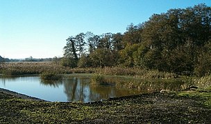
Westhay Moor is a 513.7-hectare (1,269-acre) biological Site of Special Scientific Interest 2.5 kilometres (1.6 mi) north-east of Westhay village and 4 kilometres (2.5 mi) from Wedmore in Somerset, England, notified in 1971. Westhay Moor is also notified as part of the Somerset Levels and Moors Special Protection Area under the EU Birds Directive and as a Ramsar site, and a National Nature Reserve.

<span class="mw-page-title-main">Sharpham</span> Human settlement in England

Sharpham is a village and civil parish on the Somerset Levels near Street and Glastonbury in the Mendip district of Somerset, England. It is located near the River Brue.

<span class="mw-page-title-main">Ashcott railway station</span> Disused railway station in Ashcott, Sedgemoor

Ashcott railway station was a station on the Highbridge branch of the Somerset and Dorset Joint Railway. Opened by the Somerset Central Railway in 1856 as Ashcott and Meare, the name changed to Ashcott in 1876. Consisting of a short wooden platform and station building, the station was next to a road level crossing. This was operated with a 10 lever ground frame.

<span class="mw-page-title-main">Westhay</span> Village in England

Westhay is a village in Somerset, England. It is situated in the parish of Meare, 4 miles (6.4 km) north west of Glastonbury on the Somerset Levels, in the Mendip district.

<span class="mw-page-title-main">Ham Wall</span> Wetland nature reserve in Somerset, England

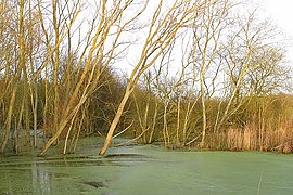
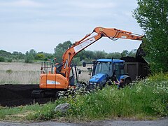
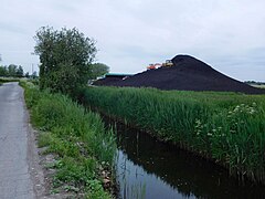
Ham Wall is an English wetland National Nature Reserve (NNR) 4 kilometres (2.5 mi) west of Glastonbury on the Somerset Levels. It is managed by the Royal Society for the Protection of Birds (RSPB). Since the last Ice Age, decomposing plants in the marshes of the Brue valley in Somerset have accumulated as deep layers of peat that were commercially exploited on a large scale in the twentieth century. Consumer demand eventually declined, and in 1994 the landowners, Fisons, gave their old workings to what is now Natural England, who passed the management of the 260 hectares Ham Wall section to the RSPB.

<span class="mw-page-title-main">Shapwick School</span> Specialist school in Shapwick, Somerset, England

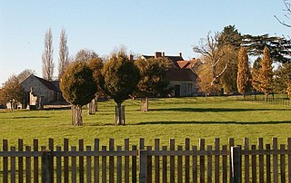
Shapwick School was a specialist school at Shapwick Manor in Shapwick, a village on the Somerset Levels in Somerset, England. In March 2020, it was announced that the school would close at the end of term in March due to financial difficulties.

<span class="mw-page-title-main">Thorne and Hatfield Moors</span> Lowland raised peat bog in England

Thorne and Hatfield Moors form the largest area of lowland raised peat bog in the United Kingdom. They are situated in South Yorkshire, to the north-east and east of Doncaster near the town of Thorne, and are part of Hatfield Chase. They had been used for small-scale extraction of peat for fuel from medieval times, and probably much earlier, but commercial extraction of the peat for animal bedding began in the 1880s. The peat was cut on the moors and, once it had dried, transported to several works on 3 ft narrow gauge tramways, always called trams locally. The wagons were pulled by horses to works at Creyke's Siding, Moorends, Medge Hall, Swinefleet and Hatfield. There was also a network of canals supplying the Moorends Works.

The Avalon Marshes Partnership is a group of conservation organisations working together in the Somerset Levels. The members are Natural England,, the Royal Society for the Protection of Birds (RSPB), the Somerset Wildlife Trust the Hawk and Owl Trust, Historic England, South West Heritage Trust and the Environment Agency. Between 2012 and 2016 the scheme was supported by a Heritage Lottery Fund grant of £1,772,500 with additional investment of £920,080 from other sources. The Avalon Marshes Centre, run by Natural England, is near the Shapwick Heath reserve. The network of reserves and private land managed for conservation in the Avalon marshes means that wetland management can be carried out on a landscape scale.

<span class="mw-page-title-main">Crowle Peatland Railway</span>

Crowle Peatland Railway is a fledgling railway museum based on the peat moors at Crowle in North Lincolnshire, England.

References

  1. 1 2 "Somerset". Natural England. Archived from the original on 29 March 2014. Retrieved 1 September 2010.
  2. "Meare Heath Bow". digitaldigging.co.uk. Archived from the original on 26 November 2011. Retrieved 15 January 2012.
  3. "Somerset Peat Paper – Issues consultation for the Minerals Core Strategy" (PDF). Somerset County Council. September 2009. p. 7. Archived from the original (PDF) on 10 March 2012. Retrieved 30 November 2011.
  4. 1 2 "Shapwick — a history". british-history.ac.uk. Retrieved 15 January 2012.
  5. "Ashcott". SDJR.net. Archived from the original on 7 February 2012. Retrieved 15 January 2012.
  6. "Accidents". SDJR.net. Archived from the original on 7 February 2012. Retrieved 15 January 2012.
  7. "Industrial Railway". Twyford Waterworks museaum. Retrieved 15 January 2012.
  8. Brunning, Richard. "Peat Wastage and Wetland Archaeology". The Ramsar Convention on Wetlands. Retrieved 21 November 2009.
  9. 1 2 3 "Fisons Eclipse Peat Works". BBC Domesday Book. Retrieved 15 January 2012.
  10. "Somerset Levels and Moors/Mid Somerset Hills" (PDF). Character Areas. Countryside Quality Counts. Archived from the original (PDF) on 19 December 2010. Retrieved 1 September 2010.
  11. "Somerset Wildlife Trust Position Statement Peat Extraction" (PDF). Somerset Wildlife Trust. February 2022. Retrieved 24 May 2023.
  12. Bradley, Ruth (27 January 2023). "Somerset Levels: Ending thousands of years of peat extraction". BBC Somerset. Retrieved 24 May 2023.