In 1847, 800 Dutch immigrants led by Dominee (Minister) Hendrik "Henry" P. Scholte settled the area known as Pella. The name "Pella" is a reference to Pella of the Decapolis, where the Christians of Jerusalem had found refuge during the Roman–Jewish war of 70;[4] the name was selected because the Dominee and his followers sought religious freedom as well. Pella was the childhood home of Wyatt Earp, whose father Nicholas Porter Earp had settled on a farm near Pella. His brothers Warren and Morgan were born in Pella.
On July 19, 2018, a destructive EF3 tornado struck the Vermeer manufacturing plant in the city. Due to early warning, only seven of the thousands of people on-site were injured.
As of the census of 2020,[7] there were 10,464 people, 3,981 households, and 2,573 families residing in the city. The population density was 1,139.6 inhabitants per square mile (440.0/km2). There were 4,271 housing units at an average density of 465.1 per square mile (179.6/km2). The racial makeup of the city was 91.2% White, 1.1% Black or African American, 0.2% Native American, 2.5% Asian, 0.2% Pacific Islander, 1.0% from other races and 3.8% from two or more races. Hispanic or Latino persons of any race comprised 2.7% of the population.
Of the 3,981 households, 27.2% of which had children under the age of 18 living with them, 55.6% were married couples living together, 3.5% were cohabitating couples, 25.0% had a female householder with no spouse or partner present and 16.0% had a male householder with no spouse or partner present. 35.4% of all households were non-families. 31.9% of all households were made up of individuals, 15.2% had someone living alone who was 65 years old or older.
The median age in the city was 37.4 years. 26.9% of the residents were under the age of 20; 10.2% were between the ages of 20 and 24; 21.2% were from 25 and 44; 21.0% were from 45 and 64; and 20.7% were 65 years of age or older. The gender makeup of the city was 48.8% male and 51.2% female.
2010 census
As of the census[8] of 2010, 10,352 people, 3,735 households, and 2,500 families resided in the city. The population density was 1,185.8 inhabitants per square mile (457.8/km2). The 4,086 housing units averaged 468.0 per square mile (180.7/km2). The racial makeup of the city was 95.0% White, 0.7% African American, 0.2% Native American, 2.3% Asian, 0.3% from other races, and 1.4% from two or more races. Hispanics of any race were 1.7% of the population.
Of the 3,735 households, 30.0% had children under the age of 18 living with them, 58.6% were married couples living together, 6.5% had a female householder with no husband present, 1.9% had a male householder with no wife present, and 33.1% were not families. About 29.5% of all households were made up of individuals, and 13.4% had someone living alone who was 65 years of age or older. The average household size was 2.40 and the average family size was 2.96.
The median age in the city was 33.3 years. About 22.3% of residents were under the age of 18; 18.4% were between the ages of 18 and 24; 21.1% were from 25 to 44; 21.8% were from 45 to 64; and 16.4% were 65 years of age or older. The gender makeup of the city was 47.7% male and 52.3% female.
2000 census
As of the census[9] of 2000, 9,832 people, 3,497 households, and 2,395 families resided in the city. The population density was 1,437.4 inhabitants per square mile (555.0/km2).
The median income for a household in the city was $45,496, and for a family was $56,321. Males had a median income of $40,344 versus $25,833 for females. The per capita income for the city was $19,674. About 3.2% of families and 7.7% of the population were below the poverty line, including 7.9% of those under age 18 and 13.9% of those age 65 or over.
Arts and culture
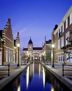
Pella's Vermeer MillFranklin Street in Pella and some of the businesses located there: Notable in the background are the Tulip Toren (tall white statue) and Information Windmill located in Pella's Central Park.Shops on Main Street in Pella illustrating Dutch architecture
Pella is home to a number of local events and architectural sites.
The Vermeer Mill is a fully functional 1850s-style windmill, reaching 134ft (41m) high. The Vermeer Mill grinds wheat into flour using only wind power and is the tallest working windmill in the United States.
The Pella Opera House, built in 1900, was renovated in 1990 and is a popular entertainment destination, featuring stained-glass windows and ornate tin ceilings. A canal winds through nearby Molengracht Plaza, home to shops, restaurants, a hostelry, a movie theatre, and a full-size working drawbridge. On June 28, 2011, Sarah Palin visited the opera house for the premiere of The Undefeated, a documentary about her role in Alaska politics and rise to national attention.[10]
The annual Tulip Time Festival is a celebration of Pella's Dutch heritage. It features tulip gardens, performances, crafters, music, food, Dutch costumes, and daily parades. The festival is held for three days (Thursday, Friday, and Saturday) during the first weekend in May. A queen and court are selected from the two high schools in the town to represent Pella and advertise the Festival. During the 2010 Festival, a world record was set for the most people dancing in wooden shoes. Over 2,600 people danced for more than six minutes to set the new standard.[11]
Pella Christian Grade School (Pre-K through 8) and Pella Christian High School (9-12) serve students in Pella and the surrounding areas.
In April 2011, Forbes rated Pella as third on its list of "The Best Schools For Your Real Estate Buck." Central College is located in Pella.[citation needed]
Parks and recreation
A few miles to the west is Lake Red Rock, Iowa's largest reservoir,[13] a popular destination for biking, hiking, boating, and fishing. The Bos Landen golf club is also in the town. The Pella Tulip Festival is held annually, honoring Pella's Dutch heritage.[14]
This page is based on this Wikipedia article Text is available under the CC BY-SA 4.0 license; additional terms may apply. Images, videos and audio are available under their respective licenses.