
Carmarthenshire is a county in the south-west of Wales. The three largest towns are Llanelli, Carmarthen and Ammanford. Carmarthen is the county town and administrative centre. The county is known as the "Garden of Wales" and is also home to the National Botanic Garden of Wales.
Llanelli is a market town and community in Carmarthenshire and the preserved county of Dyfed, Wales. It is located on the Loughor estuary and is also the largest town in the county of Carmarthenshire.

Llwynhendy, is a village and ward near the town of Llanelli in Carmarthenshire, Wales. The ward, which includes the village, as well as Cefncaeau, parts of Cwmcarnhywel and parts of Bryn and Penceilogi, had a population of 4,276.
Glanamman is a mining village in the valley of the River Amman in Carmarthenshire, Wales. Glanamman has long been a stronghold of the Welsh language; village life is largely conducted in Welsh. Like the neighbouring village of Garnant it experienced a coal-mining boom in the 19th and early 20th centuries, but the last big colliery closed in 1947 and coal has been extracted fitfully since then.

Llanelli Rural is a community in the southeast of Carmarthenshire, Wales.

Stradey Park was a rugby union stadium located near the centre of the town of Llanelli in Carmarthenshire, Wales. It was the home of the Scarlets region and Llanelli RFC rugby teams. The stadium was a combination of seating and standing with a total capacity of 10,800. Following the Scarlets' move to Parc y Scarlets in 2008, Stradey Park was demolished two years later and replaced with housing.

Garnant is a mining village in the valley of the River Amman in Carmarthenshire, Wales, north of Swansea. Like the neighbouring village of Glanamman it experienced a coal-mining boom in the 19th and early 20th centuries, but the last big colliery closed in 1936 and coal has been extracted fitfully since then. The village has the only Commissioners' church built in southwest Wales, traditionally a Methodist region.
Dafen is a village situated east of Llanelli in Carmarthenshire, Wales, part of the Llanelli Rural community. Dafen borders the villages of Felinfoel (Bryngwyn-Mawr), Bryn, Penceilogi, and Pemberton.

Llangennech ( ) is a village and community in the area of Llanelli, Carmarthenshire, Wales, which covers an area of 1,222 hectares (4.72 sq mi).
This article is a timeline of Llanelli history. For a full article on the town, see Llanelli.

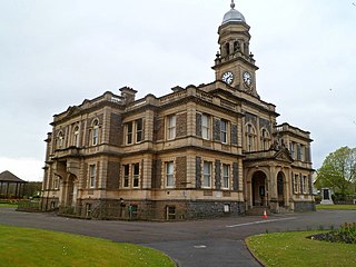
Carmarthenshire County Council is the local authority for the county of Carmarthenshire, Wales. It provides a range of services including education, planning, transport, social services and public safety. The council is one of twenty-two unitary authorities that came into existence on 1 April 1996 under the provisions of the Local Government (Wales) Act 1994. It took over local government functions previously provided by the three district councils of Carmarthen, Dinefwr, and Llanelli, as well as the county-level services in the area from Dyfed County Council, all of which councils were abolished at the same time.

Mynydd-y-Garreg or Mynyddygarreg is a village in the county of Carmarthenshire, West Wales. It borders the historic town of Kidwelly.

Llangyndeyrn is a village, community and electoral ward in the River Gwendraeth valley, Carmarthenshire, in Dyfed region of West Wales, United Kingdom. The village name is often spelt as Llangendeirne.

Llannon is a small village, community and electoral ward in the county of Carmarthenshire, Wales. It is located on the A476 road 11 mi (18 km) south east of the county town, Carmarthen, between Tumble and Swiss Valley.
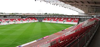
Parc y Scarlets is a rugby union stadium in Llanelli, Carmarthenshire, that opened in November 2008 as the new home of the Scarlets and Llanelli RFC.
Bynea is an electoral ward, representing part of the community of Llanelli Rural, Carmarthenshire, Wales.
Dafen is an electoral ward, representing the immediate area around the village of Dafen in the community of Llanelli Rural, Carmarthenshire, Wales.
Elli is an electoral ward for Llanelli Town Council and Carmarthenshire County Council in Llanelli, Wales.
Hengoed is an electoral ward for Carmarthenshire County Council and Llanelli Rural Council in Llanelli Rural, Carmarthenshire, Wales.
