
Many coastal peninsulas of Oregon are properly headlands, often called capes.
Many coastal peninsulas of Oregon are properly headlands, often called capes.

Unless otherwise specified the source of the list is the Oregon maps of the Smithsonian's 1899 Indian Land Cessions of the United States. [1] Ordered north to south:
Ordered alphabetically:
The coast of Oregon also has a number of significant sea stacks. [2]

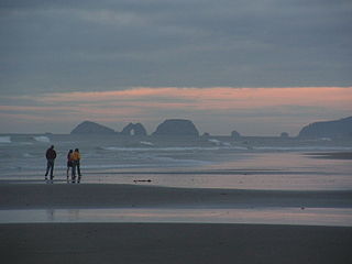
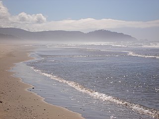
The Oregon Coast is a coastal region of the U.S. state of Oregon. It is bordered by the Pacific Ocean to its west and the Oregon Coast Range to the east, and stretches approximately 362 miles (583 km) from the California state border in the south to the Columbia River in the north. The region is not a specific geological, environmental, or political entity, and includes the Columbia River Estuary.

Cape Blanco is a prominent headland on the Pacific Ocean coast of southwestern Oregon in the United States, forming the westernmost point in the state. Cape Blanco extends farther west than any point of land in the contiguous United States except portions of the Olympic Peninsula in Washington, including Cape Alava, the true westernmost point. The cape is part of Cape Blanco State Park and is the location of the Cape Blanco Light, first lit in 1870.
Cape Lookout is a sharp rocky promontory along the Pacific Ocean coast of northwestern Oregon in the United States. It is located in southwestern Tillamook County, approximately 10 miles (16 km) southwest of Tillamook, just south of Netarts Bay. The promontory extends 1.5 miles (2.4 km) perpendicular to the coast, and is approximately 0.5 miles (0.80 km) wide at its base, tapering as it extends outward from the coast. Cape Lookout State Park is located on the north side of the promontory, which is part of the Siuslaw National Forest. Cape Lookout Road travels past the base of the cape. Cape Lookout is a member of Tillamook's Three Capes Scenic Drive.
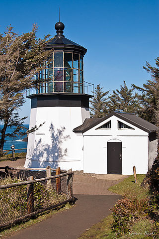
The Cape Meares Light is an inactive lighthouse on the coast of Oregon. It is located on Cape Meares just south of Tillamook Bay. It is open to the public.
Cape Meares is a small headland on the Pacific coast in Tillamook County, Oregon, United States. The cape forms a high steep bluff on the south end of Tillamook Bay, approximately five miles (8 km) northwest of the city of Tillamook. Much of the cape is part of the Oregon Parks and Recreation Department-administered Cape Meares State Scenic Viewpoint with three miles of hiking trails, which includes Cape Meares Light and the Octopus Tree. The cape is named after John Meares, a British explorer.

The Oregon Coast Trail (OCT) is a long-distance hiking route along the Pacific coast of the U.S. state of Oregon in the United States. It follows the coast of Oregon from the mouth of the Columbia River to the California border south of Brookings.

U.S. Route 101 (US 101), is a major north–south U.S. Highway in Oregon that runs through the state along the coastline near the Pacific Ocean. It runs from the California border, south of Brookings, to the Washington state line on the Columbia River, between Astoria, Oregon, and Megler, Washington.

Cape Kiwanda State Natural Area is a state park in Pacific City, Oregon, United States. Cape Kiwanda is on the Three Capes Scenic Route, which includes Cape Meares and Cape Lookout. Hiking to the top of Cape Kiwanda allows views of Nestucca Bay to the south and Cape Lookout to the north.

Heceta Head Light is a lighthouse on the Oregon Coast 13 miles (21 km) north of Florence, and 13 miles (21 km) south of Yachats in the United States. It is located at Heceta Head Lighthouse State Scenic Viewpoint, a state park, midway up a 205-foot-tall (62 m) headland. Built in 1894, the 56-foot (17 m)-tall lighthouse shines a beam visible for 21 nautical miles, making it the strongest light on the Oregon Coast.

The Cape Arago Lighthouse is a lighthouse located in Charleston, Oregon. It is located 2.6 miles (4.2 km) north of Cape Arago.

Heceta Head is a headland that stands 1,000 feet (300 m) above the Pacific Ocean in Lane County, Oregon, United States. The Heceta Head Light is located on its south side. Heceta Head is named after a Basque explorer under Spanish commission, Bruno de Heceta, who explored the Pacific Northwest in the 1770s. The headland marks the end of a lower-lying stretch of the coastline to the south dominated by sand dunes; the coastline to the north is more varied. Devils Elbow is the bay south of the headland at the mouth of Cape Creek, and with the headland formed Devils Elbow State Park, which is now part of Heceta Head Lighthouse State Scenic Viewpoint.
The Oregon Coast National Wildlife Refuge Complex consists of six National Wildlife Refuges along the Oregon Coast. It provides wilderness protection to thousands of small islands, rocks, reefs, headlands, marshes, and bays totaling 371 acres spanning 320 miles (515 km) of Oregon's coastline. The areas are all managed by the United States Fish and Wildlife Service.
Cape Meares National Wildlife Refuge is a National Wildlife Refuge of the Oregon Coast. It is one of six National Wildlife Refuges in the Oregon Coast National Wildlife Refuge Complex. Located on Cape Meares, the refuge was established in 1938 to protect a remnant of coastal old-growth forest and the surrounding habitat used by breeding seabirds. The area provides a home for a threatened bird species, the marbled murrelets. Peregrine falcons, once at the brink of extinction, have nested here since 1987. The refuge, with the exception of the Oregon Coast Trail, was designated a Research Natural Area in 1987.
Point Adams Light was a lighthouse near the mouth of the Columbia River on the Oregon Coast of the United States. The lighthouse was designed by Paul J. Pelz, who also designed Point Adams's sister stations, Point Fermin Light in San Pedro, California, East Brother Island Light in Richmond, California, Mare Island Light, in Carquinez Strait, California, Point Hueneme Light in California, and Hereford Inlet Light in North Wildwood, New Jersey, all in essentially the same style. It operated from February 15, 1875 until 1899, when it became obsolete by the extension of the south jetty and the establishment of the Lightship Columbia in 1892. The lighthouse was considered a fire hazard and demolished in 1912.

The history of steamboats on the Oregon Coast begins in the late 19th century. Before the development of modern road and rail networks, transportation on the coast of Oregon was largely water-borne. This article focuses on inland steamboats and similar craft operating in, from south to north on the coast: Rogue River, Coquille River, Coos Bay, Umpqua River, Siuslaw Bay, Yaquina Bay, Siletz River, and Tillamook Bay. The boats were all very small, nothing like the big sternwheelers and propeller boats that ran on the Columbia River or Puget Sound. There were many of them, however, and they came to be known as the "mosquito fleet."

Oceanside Beach State Recreation Site is a state park in the U.S. state of Oregon. Administered by the Oregon Parks and Recreation Department, the park is open to the public and is fee-free. Amenities at the site, in the unincorporated community of Oceanside, include picnicking, wildlife watching, fishing, windsurfing, and kite flying. It is not uncommon to see paraglider pilots land at the beach on Southwest wind days during the fall, winter and spring. Beachcombing is popular in summer, and agate hunting is best in winter, when ocean currents remove sand. Oceanside is about 11 miles (18 km) west of Tillamook off U.S. Route 101.

Cleft of the Rock Light is a privately owned lighthouse located on the Pacific coast of the U.S. state of Oregon, 1.8 miles (2.9 km) south of Yachats on Cape Perpetua.
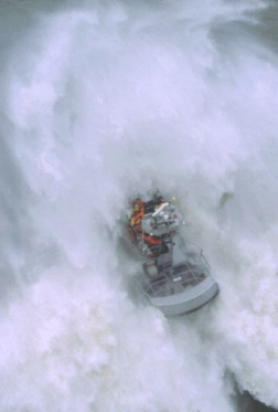
United States Coast Guard Station Cape Disappointment, situated near Cape Disappointment, Washington, at the mouth of the Columbia River, is the largest United States Coast Guard search and rescue station on the Northwest Coast, with 50 crewmembers assigned. Cape Disappointment Station is also the site of the oldest search and rescue station within the Thirteenth Coast Guard District. The station's Area of Responsibility reaches from Ocean Park on the Washington Coast south to Tillamook Head on the Oregon Coast.