
The River Camel is a river in Cornwall, United Kingdom. It rises on the edge of Bodmin Moor and with its tributaries its catchment area covers much of North Cornwall. The river flows into the eastern Celtic Sea between Stepper Point and Pentire Point having covered about 30 miles, making it the second longest river wholly in Cornwall. The river is tidal upstream to Egloshayle and is popular for sailing, birdwatching and fishing. The name Camel comes from the Cornish language for 'the crooked one', a reference to its winding course. Historically the river was divided into three named stretches. Heyl was the name for the estuary up to Egloshayle, the River Allen was the stretch between Egloshayle and Trecarne, whilst the Camel was reserved for the stretch of river between its source and Trecarne.

Lostwithiel is a civil parish and small town in Cornwall, England, United Kingdom at the head of the estuary of the River Fowey. According to the 2001 census it had a population of 2,739, increasing to 2,899 at the 2011 census. The Lostwithiel electoral ward had a population of 4,639 at the 2011 census. The name Lostwithiel comes from the Cornish "lostwydhyel" which means "tail of a wooded area".

The River Fal flows through Cornwall, England, rising at Pentevale on Goss Moor and reaching the English Channel at Falmouth. On or near the banks of the Fal are the castles of Pendennis and St Mawes as well as Trelissick Garden. The River Fal separates the Roseland peninsula from the rest of Cornwall. Like most of its kind on the south coast of Cornwall and Devon, the Fal estuary is a classic ria, or drowned river valley. The Fal estuary from Tregony to the Truro River was originally called Hafaraell.

The River Looe is a river in south-east Cornwall, which flows into the English Channel at Looe. It has two main branches, the East Looe River and the West Looe River. The eastern branch has its source near St Cleer only 0.31 miles (0.5 km) away from the Golitha Falls on the River Fowey, and flows south, passing close to the western outskirts of Liskeard. The western branch has its source near Dobwalls.

Par is a village and fishing port with a harbour on the south coast of Cornwall, England, United Kingdom. The village is situated in the civil parish of Tywardreath and Par, although West Par and the docks lie in the parish of St Blaise.

St Sampson is a civil parish in mid-Cornwall, England, United Kingdom. The population at the 2011 census was 260.

St Veep is a civil parish in Cornwall, England, United Kingdom, situated above the east bank of the River Fowey about three miles (5 km) south-east of Lostwithiel. It is bordered by the parishes of St Winnow to the north-west, Boconnoc to the north, Lanreath to the east Polperro to the south-east and Lanteglos to the south. The River Fowey forms its western boundary. The parish is named after Saint Veep of whom little is known.
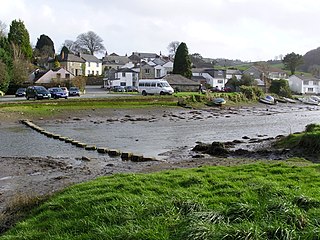
Lerryn is a village in Cornwall, United Kingdom. It is situated on the River Lerryn approximately three miles (5 km) southeast of Lostwithiel.
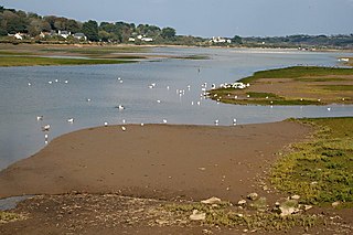
The Hayle Estuary is an estuary in west Cornwall, England, United Kingdom. It is one of the few natural harbours on the north coast of south-west England and during the prehistoric and early medieval periods was important for trade and the movement of people and ideas.

St Winnow is a civil parish in Cornwall, England, United Kingdom. Its name may be connected with either that of Saint Winnoc or Saint Winwaloe. It has a population of 304, which had increased to 328 at the 2011 census. The church town is on the east bank of the River Fowey south of Lostwithiel. Part of the village of Lerryn lies within the parish as does the Chapel of St Nectan. The Redlake Meadows & Hoggs Moor, a Site of Special Scientific Interest is also in the parish.

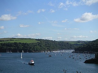
Bodinnick is a riverside village in south-east Cornwall, in the United Kingdom. According to the Post Office the population of the 2011 Census was included in the civil parish of Lanteglos-by-Fowey. It is a fishing village situated on the east bank of the River Fowey opposite the town of Fowey, also on the banks of the Fowey River. The ferry crossing is from Fowey to Bodinnick and the "Old Ferry Inn" is located on its bank glorified as "in the heart of Du Maurier country". This ferry terminal is said to have existed since the 13th century.
Pont Pill, joins the River Fowey at Penleath Point just below the memorial to Sir Arthur Quiller-Couch at the north-east corner of Fowey harbour. Pont Pill is a tidal river and is only navigable at high water.

Menabilly is a historic estate on the south coast of Cornwall, England, situated within the parish of Tywardreath on the Gribben peninsula about 2 miles (3.2 km) west of Fowey.

Lanteglos is a coastal civil parish in south Cornwall, England, United Kingdom. It is on the east side of the tidal estuary of the River Fowey which separates it from the town and civil parish of Fowey. The South West Coast Path runs along the southern coasts of the parish and much of the southern part of the parish lies in the Polruan to Polperro Site of Special Scientific Interest managed by the National Trust.

Devoran is a village in south Cornwall, England, United Kingdom. It is 4 miles (6.4 km) southwest of Truro at grid reference SW 793 392. Formerly an ecclesiastical parish, Devoran is now in the civil parish of Feock.

Restronguet Creek is a tidal ria in south Cornwall, United Kingdom. It is a tributary of Carrick Roads, the estuary of the River Fal, and is situated approximately four miles (6.5 km) south of Truro and three miles (5 km) north of Falmouth.
Penpol may refer to several places in Cornwall, England:

Chycoose, Point and Penpol form a coastal settlement around Penpol Creek in Cornwall, England, United Kingdom.
Presented below is an alphabetical index of articles related to Cornwall:
