Related Research Articles

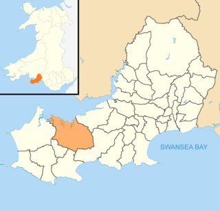
Gower electoral ward is an electoral ward in Britain. It is a ward of the City and County of Swansea, and comprises the western part of the Gower Peninsula. It lies within the UK Parliamentary constituency of Gower.

Pendine is a village and community in Carmarthenshire, Wales. Situated on the northern shore of Carmarthen Bay and bordered by the communities of Eglwyscummin and Llanddowror, the population at the 2011 census was 346.
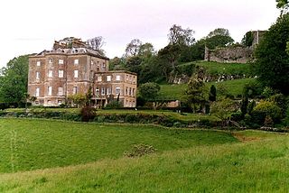
Penrice Castle is a 13th-century castle near Penrice, Swansea on the Gower Peninsula, Wales. Nearby is a neo-classical mansion house built in the 1770s. The mansion is a Grade I listed building and the surrounding gardens and park is also listed at Grade I on the Cadw/ICOMOS Register of Parks and Gardens of Special Historic Interest in Wales.
Gowerton is a large village and community, about 4 miles (6 km) north west of Swansea city centre, Wales. Gowerton is often known as the gateway to the Gower Peninsula. Gowerton's original name was Ffosfelin. The village falls within the Gowerton electoral ward of the City and County of Swansea Council, which elects one councillor. The community had a population of 5,212. and the built-up area with Waunarlwydd 8,183.

Llangyfelach is a village and community located in the City and County of Swansea, Wales. Llangyfelach is situated about 4 miles north of the centre of Swansea, just west of Morriston. It falls within the Llangyfelach ward. To the west is open moorland. The population was 2,510 as of the 2011 UK census. The name is seemingly derived from a combination of 'llan' and 'Cyfelach', with a mutation to combine them for Llangyfelach.

Llanelli Rural is a community in the southeast of Carmarthenshire, Wales.

Llanddew is a small village and community about 2 km or 1 mile north-east of Brecon, Powys, Wales. The population as of the 2011 UK Census was 232. It is in the historic county of Brecknockshire (Breconshire).

Llanrhidian Higher is a local government community in Swansea, south Wales. The community has its own elected community council.
Llanrhidian Lower is a community in the Gower peninsula forming the west of Swansea, south Wales. The community has its own elected community council. The population was 512 as of the 2011 UK census.
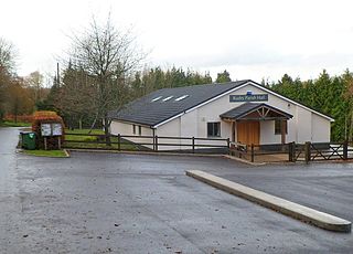
Rudry is a small village and community located to the east of Caerphilly in Wales. As a community Rudry contains not only the village of Rudry, but also the villages of Draethen, Garth and Waterloo. The population of the community at the 2011 census was 1,053.

Gladestry is a small village and community in Radnorshire, Powys, mid-Wales, close to the border with England at the end of the Hergest Ridge and south of the large moorland area of Radnor Forest. People living in Gladestry rely on the nearby town of Kington, Herefordshire, for shops, employment, and public services.
Llanedi is a village and community in Carmarthenshire, Wales. Once the name of a parish, Llanedi is now a community taking in the hamlet of Llanedi and the villages of Hendy, Fforest and Tycroes. The community population taken at the 2011 census was 5,664. The community is located between Ammanford and Llanelli.
Bryncethin is a small village and electoral ward in the County Borough of Bridgend, South Wales, located just north of Junction 36 of the M4 Motorway and approximately 3 miles north of the county town of Bridgend. The population of the ward was 1,319 in 2011.

Penllergaer is the name of an electoral ward in the City and County of Swansea, Wales, UK. Penllergaer has its own elected community council.

Pennard is a village and community on the south of the Gower Peninsula, about 7 miles south-west of Swansea city centre. It falls within the Pennard electoral ward of Swansea. The Pennard community includes the larger settlements of Southgate and Kittle. the population as of 2011 was 2,688.
Llangeinor is a small village located in the Garw Valley around 5 miles (8 km) north of Bridgend in Bridgend County Borough, Wales. The ward population taken at the 2011 census was 1,243. The entire village is now protected as part of a conservation area.

Kilvrough Manor is a large country house near Swansea. It is a Grade II* listed building. Its park is listed on the Cadw/ICOMOS Register of Parks and Gardens of Special Historic Interest in Wales.
Ilston is the name of a village and a local government community in Swansea, southwest Wales. Ilston has its own community council.
Reynoldston is a rural village and a community in the City and County of Swansea, Wales, which had a population of 439 in 2011. The community has its own elected community council. The village is located deep in the heart of the Gower Peninsula.
References
- ↑ readers, Guardian (1 March 2015). "Hotel and hostel accommodation in Wales: readers' travel tips". The Guardian. ISSN 0261-3077 . Retrieved 13 January 2020– via www.theguardian.com.
- ↑ UK Census (2011). "Local Area Report – Penrice Parish (W04000588)". Nomis. Office for National Statistics . Retrieved 13 January 2020.
- ↑ Etherington, Jan (15 April 2002). "Wales: Take me to the beach". ISSN 0307-1235 . Retrieved 13 January 2020– via www.telegraph.co.uk.
Coordinates: 51°34′N4°11′W / 51.567°N 4.183°W
| | This Swansea location article is a stub. You can help Wikipedia by expanding it. |