Pensacola Beach, Florida

Last updated

Pensacola Beach, Florida
Pensacola Beach, United States (Unsplash).jpg
A lifeguard stand on Pensacola Beach.
USA Florida location map.svg
Red pog.svg
Pensacola Beach
Coordinates: 30°19′56″N87°8′30″W / 30.33222°N 87.14167°W / 30.33222; -87.14167
CountryFlag of the United States.svg  United States
StatesFlag of Florida.svg  Florida
County Escambia
Founded by Tristan de Luna
Area
  Total29.943 km2 (11.561 sq mi)
  Land29.660 km2 (11.452 sq mi)
  Water0.283 km2 (0.109 sq mi)
Time zone UTC-6 (CST)
  Summer (DST) UTC-5 (CDT)
ZIP code
32561
Area code 850
Website
The sand color is exceptionally white, as seen in this 1957 photo. Pensacola Beach 1957 White Sand.jpg
The sand color is exceptionally white, as seen in this 1957 photo.

Pensacola Beach is an unincorporated community located on Santa Rosa Island, a barrier island, in Escambia County, Florida, United States. It is situated south of Pensacola (and Gulf Breeze connected via bridges spanning to the Fairpoint Peninsula and then to the island) in the Gulf of Mexico. As of the 2000 census, the community had a total population of 2,738. It has been described as "famous" for its ultra-white sand beaches. [1] [2]

Contents

Pensacola Beach occupies land bound by a 1947 deed from the United States Department of Interior that it be administered in the public interest by the county or leased, but never "disposed"; its businesses and residents are thus long-term leaseholders and not property owners. [3]

Pensacola Beach is part of the PensacolaFerry PassBrent Metropolitan Statistical Area, which includes all of Escambia and Santa Rosa counties.

History

Also see: History of Pensacola, Florida.

Francisco Maldonado, a lieutenant [4] under Conquistador Hernando de Soto, visited the area during the early Spanish exploration of North America. He anchored in Pensacola Bay for the winter of 1539–1540. [5] [6]

In 1559, Don Tristan de Luna y Arellano led the first settlement of the region. [4] His 11 ships, with 1500 settlers, [4] anchored in the bay and established its colony on the site of today's Naval Air Station Pensacola. Shortly after their arrival, on August 15, 1559, Friar Dominic de la Anunciacion conducted what is believed to be the first Christian religious service in the present-day United States. [7] This event is commemorated by a marker near the possible site of the service, indicating the historical significance of the location as a place of early religious and cultural exchange.

A hurricane decimated the colony a few weeks later, killing hundreds and sinking five ships. [4] Suffering long-term famine and fighting, this first settlement was finally abandoned in 1561. [4] A presidio was constructed on Santa Rosa Island in 1722 near the location of the more recent Fort Pickens. Hurricanes in 1741 and 1752 [5] forced its relocation to the mainland.

Pensacola Beach for many years remained largely undeveloped. The Casino Resort was the first tourist destination constructed on the island (at the present day location of Casino Beach) where a variety of special events including beauty pageants, fishing tournaments, and boxing matches were held from the 1930s through 1950s. With a bar, tennis courts, bath houses, and a restaurant, it was a popular resort until it eventually closed in the 1960s.

The entire island was initially owned by the federal government. In order to promote infrastructure and growth on the island, the federal government leased the lands now encompassing Pensacola Beach to the Santa Rosa Island Authority (SRIA), which in turn has leased the property to homeowners. As a result, all structures on the island have 99-year renewable leases with the SRIA rather than ownership of the land itself.

Geography

Pensacola Beach is located at 30°20′00″N87°08′15″W / 30.33333°N 87.13750°W / 30.33333; -87.13750 , on the barrier island of Santa Rosa. It is bordered to the south by the Gulf of Mexico, to the north by Santa Rosa Sound and Pensacola Bay, and to the east and west by the Gulf Islands National Seashore.

Climate

Pensacola Beach in 2022 Pensacola Beach Florida.jpg
Pensacola Beach in 2022

While generally cooler than most of peninsular Florida, Pensacola Beach maintains a more stable temperature year round than inland areas of Pensacola and Escambia County. As such, winter lows are several degrees warmer than Pensacola proper and summer highs are generally cooler as a result of the surrounding waters.

As with many islands, Pensacola Beach enjoys sea breezes which begin around noon and end around sunset in the summer, and there are often afternoon thunderstorms. The average temperature ranges from 44 °F (7 °C) in January to 89 °F (32 °C) in July. [8]

Hurricanes

As a community located on a low-lying barrier island, Pensacola Beach is vulnerable to hurricanes. Landfalling storms have been known to drive storm surge over the island, damaging or destroying man-made structures and causing beach erosion. [9] In 1995, two hurricanes made landfall on the island. Hurricane Erin made landfall in August, and Hurricane Opal blasted the island just two months later, leveling some dunes and destroying a number of homes. [10]

On September 16, 2004, Hurricane Ivan devastated the Pensacola Beach area, destroying more than 650 homes and damaging many others. Ivan was the last hurricane to make Florida landfall in 2004, one of the most destructive hurricane seasons in decades. [11]

On July 10, 2005, Hurricane Dennis made landfall between Pensacola Beach and eastern Navarre Beach. However, as with Erin almost a decade earlier, the damage on Pensacola Beach was not nearly as extensive as predicted.

In 2020, Pensacola Beach took the brunt of the storm from Hurricane Sally, seeing widespread wind damage, storm surge flooding, and over 20 inches (510 mm) of rainfall. [12] [13] A section of the Pensacola Bay Bridge (known to locals as the Three Mile Bridge) was destroyed during Hurricane Sally. [14]

The island has been subject to mandatory evacuation orders during some of these hurricanes. [15]

Oil spill

The Deepwater Horizon , a BP-operated oil-drilling rig in the Gulf of Mexico off the Louisiana coast, exploded April 20, 2010, eventually releasing almost 5 million barrels of oil into the Gulf before being capped on August 4, 2010. [16] Oil from the explosion did not reach Pensacola beaches until June 4, 2010. [17] Crews posted along Escambia County's coastline quickly cleaned much of the oil that was evident along the beaches. [18] Tourism in the Pensacola Beach area was adversely affected during the summer of 2010. [19] BBC News reported that swimmers at Pensacola Beach "encountered an oil sheen and children picked up tar blobs as big as tennis balls." [20]

Public transportation

Fire Station #13. Pensacolabeachfirestationfirestation.jpg
Fire Station #13.

Escambia County Area Transit (ECAT) provides bus transportation seven days per week. [21]

Government and infrastructure

Escambia County Fire Rescue operates Fire Station #13 in Pensacola Beach. [22]

The Escambia County Sheriff's Office has Precinct 1 covering Pensacola Beach, operated out of the Pensacola Beach Sheriff's Substation. [23]

Attractions

Casino Beach

Gulf Pier, located on Pensacola Beach, is 1,471 feet long. The beach at Gulf Pier in Pensacola Beach, Florida.jpg
Gulf Pier, located on Pensacola Beach, is 1,471 feet long.

The hub of beach activity, Casino Beach, on Pensacola Beach, is named after the original casino that stood in this location and is a popular beach access. [25] The location is dotted with restaurants and family entertainment areas.[ citation needed ] It is situated next to the Pensacola Beach Gulf Pier, which at 1,471 feet is described as the longest pier on the Gulf of Mexico. [26] The beach is equipped with lifeguard stands and station, volleyball courts, snack bar and large parking lot. The Gulfside Pavilion hosts a "Bands on the Beach" concert series during the summer tourist season. [27]

Gulf Pier

An aerial view of the Gulf Pier, showing how far the pier extends out into the gulf. PensacolaBeachgulfpier.jpg
An aerial view of the Gulf Pier, showing how far the pier extends out into the gulf.


The Gulf Pier has been called an iconic part of Pensacola Beach by residents. It is maintained by Escambia County Public Works and the Santa Rosa Island Authority. [28] In addition to fishing, [29] the pier offers sightseeing marine wildlife such as dolphins and stingrays. [30] [31] It has been closed and renovated a number of times due to storm and hurricane damage. [32] [33] [34]

A United States Navy Blue Angels F/A-18 Hornet Fighter Jet flying over Pensacola Beach. US Navy 110707-N-BA418-065 An F-A-18 Hornet flies inverted over Pensacola Beach while performing the double farvel maneuver during a practice fligh.jpg
A United States Navy Blue Angels F/A-18 Hornet Fighter Jet flying over Pensacola Beach.

Blue Angels

Pensacola beach is known for flyovers by the Blue Angels demonstration team from the nearby Pensacola Naval Air Station base. An annual air show is held each summer. [35]

Quietwater Beach Boardwalk

The Boardwalk is on the Santa Rosa Sound side of the island, directly across from Casino Beach. Retail shops, restaurants, nightclubs, street musicians and sidewalk artists line it. The Boardwalk has a large sea shell stage where concerts are held several times a year. [36]

Fort Pickens

Located at the western end of Santa Rosa Island, Fort Pickens was completed in 1834 and used until World War II, when modern weapons made traditional coastal defenses obsolete. It is open to the public as part of the Gulf Islands National Seashore, with a fee required for entry; campsites are also available for a fee.

Architecture

Commercial Buildings

A Pensacola Beach sign welcomes drivers from Gulf Breeze Parkway to Pensacola Beach Road. Pensacola Beach Sign.jpg
A Pensacola Beach sign welcomes drivers from Gulf Breeze Parkway to Pensacola Beach Road.

Pensacola Beach is home to some of the tallest buildings between Tallahassee and Mobile, Alabama. [37] The list below ranks the buildings in height.

  1. Portofino Towers (255 feet, 78 m).
  2. Verandas Tower (255 feet, 78 m).
  3. Beach Club (243 feet, 74 m).
  4. Hilton Pensacola Beach Resort (206 feet, 63 m).
  5. Santa Rosa Towers (206 feet, 63 m).
  6. Emerald Isle Condominium (206 feet, 63 m).
  7. Santa Rosa Towers (206 feet, 63 m).
  8. Tristan Towers (194 feet, 59 m).

Landmarks

Pensacola Beach Welcome Sign

Another historical landmark is the vintage Pensacola Beach Sign just outside Pensacola Beach in Gulf Breeze. It was a 60s-era neon sign that directs drivers towards Pensacola Beach's "scenic" views of the coast of the Gulf of Mexico, as well as towards its white sand beaches, motels, and restaurants. [38] The sign was renovated in 2019 to look exactly like the old sign but feature LED lights instead of neon. [39] [40]

Beach ball water tower

The beach ball painted water tower is an iconic symbol of Pensacola Beach. [41] Today the water tower is no longer in use, but has been preserved by the city as a historical landmark. [42]

Novelty houses

Pensacola's Futuro house. UFOhousepensacola.JPG
Pensacola's Futuro house.
"Dome of a Home" in Pensacola Beach, FL. Domehousepensacola2.JPG
"Dome of a Home" in Pensacola Beach, FL.

Pensacola Beach is home to several novelty houses, which are homes built with unusual shapes for purposes such as publicity or to copy other famous buildings in parody.

One of the novelty houses in Pensacola is the house "Dome of a Home", built in 2002 using a monolithic dome in the form of a large concrete dome, designed to structurally withstand storm surge and hurricane-force winds of 133 metres per second (300 mph). It withstood hurricanes Ivan and Dennis. It is also known as the "Flintstone Home" due to the fact it resembles a rock home. [43]

Another novelty house is the house with a UFO-shaped Futuro attached as a second story. This Futuro house is sometimes called the "Spaceship House." It was designed in the 1960s by Finnish architect Matti Suuronen. About a hundred of them were constructed. [44]

Education

Pensacola Beach Elementary School. PensacolaBeachES.jpg
Pensacola Beach Elementary School.

There is one school on Pensacola Beach. The Pensacola Beach Elementary School, within the Escambia County School District (ECSD), is for children from kindergarten through fifth grade. This school has an enrollment ranging from 120 to 140 students. All elementary-school age children on Pensacola Beach are eligible to attend the school. The first year the school was open, for the school year 1977–1978, classes were held in an empty A-frame house. The Pensacola Beach Volunteer Fire Department building was also used in aiding the teachers and administrators. In November 1977, four portable buildings were moved to the present site. They school has received the 5 Star School award since 1998.[ citation needed ] In 2001 the Pensacola Beach Elementary lost its direct district operational control and became a charter school. [45] In September 2004 Hurricane Ivan destroyed an office and four classrooms. Jeff Castleberry, the principal, argued that ECSD would have closed the school if it had direct operational control. The costs to fix the damage at Pensacola Beach Elementary was $1.5 million. The campus is adjacent to the Gulf of Mexico and is built on stilt. The school has been described as one of several Escambia County charter schools that "exemplify charter schools at their finest". [46]

Pensacola Beach is zoned for (assigned to) a different ECSD elementary school, Suter Elementary School, [47] as well as Workman Middle School, [48] and Pensacola High School. [49] However, most middle- and high-school students in Pensacola Beach attend Gulf Breeze Middle School and Gulf Breeze High School, operated by Santa Rosa County School District. [45] In addition, some attend Pensacola-area magnet schools. [50]

Religion

There are only two traditional churches on the island of Pensacola Beach. It is under the laws and guidelines of the Santa Rosa Island Authority that these be the only churches on the island. However, since around 2011, at least two other area churches have held satellite church meetings and openly worshipped on the water's edge on Sunday mornings.[ citation needed ]

See also

Related Research Articles

<span class="mw-page-title-main">Escambia County, Florida</span> County in Florida, United States

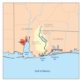
Escambia County is the westernmost and oldest county in the U.S. state of Florida. It is in the state's northwestern corner. At the 2020 census, the population was 321,905. Its county seat and largest city is Pensacola. Escambia County is included within the Pensacola-Ferry Pass-Brent, Florida, Metropolitan Statistical Area. The county population has continued to increase as the suburbs of Pensacola have developed.

<span class="mw-page-title-main">Santa Rosa County, Florida</span> County in Florida, United States

Santa Rosa County is a county located in the northwestern portion of the U.S. state of Florida. As of 2020, the population was 188,000. The county seat is Milton, which lies in the geographic center of the county. Other major communities within Santa Rosa County are Navarre, Pace, and Gulf Breeze. Navarre is the most populated community with a population of approximately 45,000 residents. Santa Rosa County is included in the Pensacola Metropolitan Statistical Area, which also includes Escambia County.

<span class="mw-page-title-main">Pensacola, Florida</span> City in Florida, United States

Pensacola is the westernmost city in the Florida Panhandle. It is the county seat and only incorporated city of Escambia County, Florida, United States. At the 2020 census, the population was 54,312. It is the principal city of the Pensacola metropolitan area, which had 509,905 residents in 2020.

<span class="mw-page-title-main">Gulf Breeze, Florida</span> City in Florida, United States

Gulf Breeze is a city in Santa Rosa County, Florida. It is a suburb of Pensacola, and is in the Pensacola Metropolitan Area. The population was 6,340 in 2020 and is 6,963 as of 2024.

<span class="mw-page-title-main">Pensacola High School</span> American public high school

Pensacola High School is a secondary school located near downtown Pensacola, Florida, United States.

<span class="mw-page-title-main">Florida panhandle</span> Northwest region of Florida

The Florida panhandle is the northwestern part of the U.S. state of Florida. It is a salient roughly 200 miles (320 km) long, bordered by Alabama on the north and the west, Georgia on the north, and the Gulf of Mexico to the south. Its eastern boundary is arbitrarily defined. It is defined by its southern culture and rural geography relative to the rest of Florida, as well as closer cultural links to French-influenced Louisiana, Mississippi, and Alabama. Its major communities include Pensacola, Navarre, Destin, Panama City Beach, and Tallahassee.

<span class="mw-page-title-main">Hurricane Ivan</span> Category 5 Atlantic hurricane in 2004

Hurricane Ivan was a large, long-lived, Cape Verde hurricane that caused widespread damage in the Caribbean and United States. The cyclone was the ninth named storm, the sixth hurricane and the fourth major hurricane of the active 2004 Atlantic hurricane season.

<span class="mw-page-title-main">Santa Rosa Island (Florida)</span> Island of Pensacola in Florida, United States

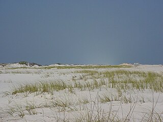
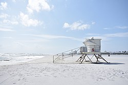
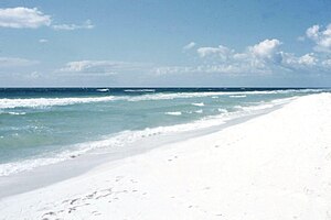
Santa Rosa Island is a 40-mile (64 km) barrier island located in the U.S. state of Florida, thirty miles (50 km) east of the Alabama state border. The communities of Pensacola Beach, Navarre Beach, and Okaloosa Island are located on the island. On the northern side of the island, are Pensacola Bay on the west and Choctawhatchee Bay on the east, joined through Santa Rosa Sound.

<span class="mw-page-title-main">Navarre, Florida</span> Census-designated place and unincorporated community in Florida, US

Navarre is a census-designated place and unincorporated community in Santa Rosa County in the northwest Florida Panhandle. It is a major bedroom community for mostly U.S. military personnel, federal civil servants, local population, retirees and defense contractors. Due to Navarre Beach and the 4 miles (6.4 km) of beach front on the Gulf of Mexico thereof, as well as several miles of beaches within the Navarre Beach Marine Park and the Gulf Islands National Seashore, it has a small, but rapidly growing community of nature enthusiasts and tourists. Navarre has grown from being a small town of around 1,500 in 1970 to a town with a population estimated at 43,540 as of 2020, if including both the Navarre and Navarre Beach Census Designated Places.

<span class="mw-page-title-main">Gulf Islands National Seashore</span> 96,000 underwater acres in Mississippi and Florida (US) managed by the National Park Service

Gulf Islands National Seashore is an American National seashore that offers recreation opportunities and preserves natural and historic resources along the Gulf of Mexico barrier islands of Florida and Mississippi. In 2023, it was the fifth-most visited unit of the National Park Service.

<span class="mw-page-title-main">Perdido Key, Florida</span> Unincorporated community in Florida, United States

Perdido Key is an unincorporated community in Escambia County, Florida located between Pensacola, Florida and Orange Beach, Alabama. The community is located on and named for Perdido Key, a barrier island in northwest Florida and southeast Alabama. "Perdido" means "lost" in the Spanish and Portuguese languages. The Florida district of the Gulf Islands National Seashore includes the east end of the island, as well as other Florida islands. No more than a few hundred yards wide in most places, Perdido Key stretches some 16 miles (26 km) from near Pensacola to Perdido Pass Bridge near Orange Beach.

<span class="mw-page-title-main">Gulf Breeze High School</span> Public school in Florida, United States

Gulf Breeze High School is a public secondary school located at 675 Gulf Breeze Parkway in Gulf Breeze, Florida. It is one of eleven high schools of the Santa Rosa County School District and the only high school in the city of Gulf Breeze.

<span class="mw-page-title-main">Hurricane Erin (1995)</span> Category 2 Atlantic hurricane in 1995

Hurricane Erin was the first hurricane to strike the contiguous United States since Hurricane Andrew in 1992. The fifth tropical cyclone, fifth named storm, and second hurricane of the unusually active 1995 Atlantic hurricane season, Erin developed from a tropical wave near the southeastern Bahamas on July 31. Moving northwestward, the cyclone intensified into a Category 1 hurricane on the Saffir–Simpson scale near Rum Cay about 24 hours later. After a brief jog to the north-northwest on August 1, Erin began moving to the west-northwest. The cyclone then moved over the northwestern Bahamas, including the Abaco Islands and Grand Bahama. Early on August 2, Erin made landfall near Vero Beach, Florida, with winds of 85 mph (137 km/h). The hurricane weakened while crossing the Florida peninsula and fell to tropical storm intensity before emerging into the Gulf of Mexico later that day.

<span class="mw-page-title-main">Tropical Storm Arlene (2005)</span> Atlantic tropical storm in 2005

Tropical Storm Arlene was an unusually large and early-forming tropical storm, being the first of twenty-eight different storms during the 2005 Atlantic hurricane season, which would become the second most active season on record. Tropical Storm Arlene formed near Honduras on June 8 and moved northwards. It crossed western Cuba on June 10 and strengthened to just under hurricane strength before making its final landfall on the Florida Panhandle the next day. The storm weakened as it continued to move north over the United States, becoming extratropical on June 13. Arlene was responsible for two deaths and minor damage.

<span class="mw-page-title-main">Pensacola Bay</span> A bay in the northwestern part of Florida, United States, known as the Florida Panhandle

Pensacola Bay is a bay located in the northwestern part of Florida, United States, known as the Florida Panhandle.

Oriole Beach is an unincorporated community located in Santa Rosa County, Florida, United States on Santa Rosa Sound. It lies east of Gulf Breeze on the Fairpoint Peninsula, and about three miles north of Pensacola Beach. Oriole Beach is part of the Pensacola–Ferry Pass–Brent Metropolitan Statistical Area.

<span class="mw-page-title-main">Pensacola metropolitan area</span> Metropolitan statistical area in Florida, United States

The Pensacola metropolitan area is the metropolitan area centered on Pensacola, Florida. It is also known as the Pensacola-Ferry Pass-Brent Metropolitan Statistical Area, a metropolitan statistical area (MSA) used for statistical purposes by the United States Census Bureau and other agencies. The Pensacola Standard Metropolitan Statistical Area was first defined in 1958, with Pensacola as the principal city, and included Escambia and Santa Rosa counties. The SMA was renamed Pensacola-Ferry Pass-Brent MSA in 2003, with the unincorporated census-designated places Ferry Pass and Brent added as principal cities. The population of the MSA in the 2020 census was 511,502.

<span class="mw-page-title-main">Effects of Hurricane Dennis in Florida</span>

The effects of Hurricane Dennis in Florida included 14 deaths and $1.5 billion in damage. The tropical wave that became Hurricane Dennis formed on June 29, 2005, and proceeded westward across the Atlantic Ocean. It became a tropical depression on July 4, a tropical storm on July 5, and a hurricane on July 7. Dennis rapidly intensified to attain Category 4 status on the Saffir-Simpson Hurricane Scale, and made landfall in Cuba where it weakened to Category 1 status, before re-emerging in the Gulf of Mexico and re–intensifying. The storm made landfall as a Category 3 hurricane on Santa Rosa Island on July 10.

<span class="mw-page-title-main">Pensacola Pass</span> Inlet on the Florida panhandle coast

Pensacola Pass is an inlet between Santa Rosa Island and Perdido Key at the western end of the Florida Panhandle. It connects the Gulf of Mexico to Pensacola Bay. The mainland around Pensacola Bay is heavily developed, with high-rise condominiums. Santa Rosa Island and the eastern part of Perdido Key adjacent to Pensacola Pass are units of the Gulf Islands National Seashore, and remain largely undeveloped.

<span class="mw-page-title-main">Hurricane Sally</span> Category 2 Atlantic hurricane in 2020

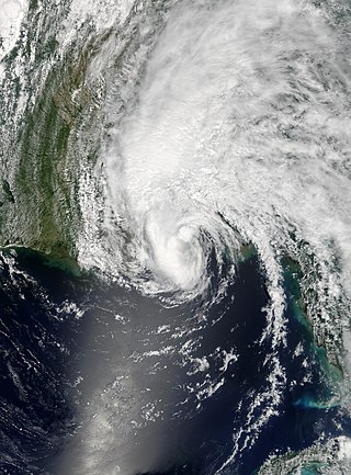
Hurricane Sally was a destructive and slow-moving Atlantic hurricane that was the first hurricane to make landfall in the U.S. state of Alabama since Ivan in 2004, coincidentally on the same date in the same place. The eighteenth named storm and seventh hurricane of the extremely active 2020 Atlantic hurricane season, Sally developed from an area of disturbed weather which was first monitored over the Bahamas on September 10. The system grew a broad area of low-pressure on September 11, and was designated as a tropical depression late that day. Early the next day, the depression made landfall at Key Biscayne and subsequently strengthened into Tropical Storm Sally that afternoon. Moderate northwesterly shear prevented significant intensification for the first two days, but convection continued to grow towards the center and Sally slowly intensified. On September 14, a center reformation into the center of the convection occurred, and data from a hurricane hunter reconnaissance aircraft showed that Sally had rapidly intensified into a strong Category 1 hurricane. However, an increase in wind shear and upwelling of colder waters halted the intensification and Sally weakened slightly on September 15 before turning slowly northeastward. Despite this increase in wind shear, it unexpectedly re-intensified, reaching Category 2 status early on September 16 before making landfall at peak intensity at 09:45 UTC on September 16, near Gulf Shores, Alabama, with maximum sustained winds of 110 mph (180 km/h) and a minimum central pressure of 965 millibars (28.5 inHg). The storm rapidly weakened after landfall before transitioning into an extratropical low at 12:00 UTC the next day. Sally's remnants lasted for another day as they moved off the coast of the Southeastern United States before being absorbed into another extratropical storm on September 18.

References

  1. "Pensacola Beach". Pensacola News Journal. Archived from the original on August 16, 2021. Retrieved August 16, 2021.
  2. Kelly, Leslie. "How Is The Margarita At Jimmy Buffett's Margaritaville?". Forbes. Archived from the original on August 16, 2021. Retrieved August 16, 2021.
  3. "Beach Leaseholders' Lawsuit Filed" Archived May 31, 2008, at the Wayback Machine Pensacola Beach Blog (December 21, 2004). Retrieved October 18, 2007.
  4. 1 2 3 4 5 "The Spanish Presence in Northwest Florida – 1513 to 1705" (history), University of West Florida, 2006, webpage: UWF-hist Archived December 9, 2012, at the Wayback Machine .
  5. 1 2 "Santa Rosa Island – A History (Part 1)" (PDF). Archived (PDF) from the original on June 14, 2007. Retrieved January 24, 2007.
  6. "Pensacola" (in Italian). Archived from the original on June 5, 2008. Retrieved January 24, 2007.
  7. Moon, Troy. "Pensacola was site of first Christian service in New World". Pensacola News Journal. Retrieved December 27, 2023.
  8. "Global Summary of the Year Location Details: Pensacola, FL US, CITY:US120032 | Climate Data Online (CDO) | National Climatic Data Center (NCDC)". www.ncdc.noaa.gov. Archived from the original on July 18, 2018. Retrieved July 17, 2018.
  9. Eliott C. McLaughlin, Christina Maxouris, Eric Levenson and Amir Vera (October 12, 2020). "Hurricane Delta leaves at least four dead and knocks out power for hundreds of thousands". CNN. Archived from the original on January 27, 2021. Retrieved September 2, 2021.{{cite web}}: CS1 maint: multiple names: authors list (link)
  10. Peck, Lee. "TS Fred a minor inconvenience for Pensacola Beach". FOX10 News. Archived from the original on September 2, 2021. Retrieved September 2, 2021.
  11. Miller, Kimberly. "Hurricane Sally's storm surge in Pensacola was historic, but we still don't know how bad it got". The Palm Beach Post. Archived from the original on February 2, 2021. Retrieved September 2, 2021.
  12. "Hit by COVID, Gulf tourism now gets slammed by Hurricane Sally". www.aljazeera.com. Archived from the original on September 2, 2021. Retrieved September 2, 2021.
  13. "Photos: Hurricane Sally causes widespread flooding". CNN. September 16, 2020. Archived from the original on September 2, 2021. Retrieved September 2, 2021.
  14. Harmeet Kaur and Tina Burnside (September 16, 2020). "A section of Pensacola's Three Mile Bridge is missing as Hurricane Sally lashes Gulf Coast". CNN. Archived from the original on September 2, 2021. Retrieved September 2, 2021.
  15. CNN reporter struggles to brave Hurricane Sally winds - CNN Video, September 16, 2020, archived from the original on September 2, 2021, retrieved September 2, 2021
  16. "Oil From Deepwater Horizon Spill Could Take At Least 30 Years to Decompose, Study Finds". Yale E360. Archived from the original on September 2, 2021. Retrieved September 2, 2021.
  17. Gabriel, Melissa Nelson. "Tar balls on Pensacola Beach from 2010 BP oil spill could last at least 30 years, study says". Pensacola News Journal. Archived from the original on September 2, 2021. Retrieved September 2, 2021.
  18. "Oil outrage on Pensacola Beach - CNN.com". www.cnn.com. Archived from the original on September 2, 2021. Retrieved September 2, 2021.
  19. "Oil soaks miles of Pensacola Beach - CNN.com". www.cnn.com. Archived from the original on September 2, 2021. Retrieved September 2, 2021.
  20. "BBC News - Barack Obama cautious on new move to halt Gulf oil leak". June 4, 2010. Archived from the original on September 2, 2021. Retrieved September 2, 2021.
  21. "Archived copy" (PDF). Archived from the original (PDF) on September 17, 2013. Retrieved November 26, 2013.{{cite web}}: CS1 maint: archived copy as title (link)
  22. "Escambia Fire Stations Archived February 1, 2017, at the Wayback Machine ." Escambia County. Retrieved on January 31, 2017.
  23. "Precincts Archived January 13, 2017, at the Wayback Machine ." Escambia County Sheriff's Office. Retrieved on January 31, 2017.
  24. "Pensacola Beach Fishing Pier". Visit Pensacola. Retrieved March 8, 2022.
  25. Cosson, Derek (February 22, 2016). "Remembering Pensacola Beach the Way it Was". Archived from the original on November 29, 2018. Retrieved November 28, 2018.
  26. Hu, Winnie (December 23, 2005). "36 Hours in Pensacola, Fla". The New York Times. ISSN   0362-4331. Archived from the original on September 2, 2021. Retrieved September 2, 2021.
  27. "Santa Rosa Island Authority: Bands on the Beach". visitpensacolabeach.com. Archived from the original on November 29, 2018. Retrieved November 28, 2018.
  28. WEAR Staff (June 24, 2021). "Pensacola Beach fishing pier set to reopen Saturday morning". WEAR. Retrieved March 8, 2022.
  29. Warren-Hicks, Colin. "REWIND: Blue Angels take to skies over Pensacola Beach for final show of season". Pensacola News Journal. Retrieved March 8, 2022.
  30. Newby, Jake. "Why zillions of stingrays are gathering off this Fla. beach". USA TODAY. Retrieved March 8, 2022.
  31. Blair, Kimberly. "Dolphin eludes would-be rescuers off Florida pier". USA TODAY. Retrieved March 8, 2022.
  32. Henderson, Kristie (September 5, 2018). "Pensacola Beach Gulf Pier closed due to storm damage". WEAR. Retrieved March 8, 2022.
  33. "Tropical Storm Damage Closes Pensacola Beach Pier : NorthEscambia.com" . Retrieved March 8, 2022.
  34. "Escambia Beaches Reopen Friday. Here's What You Need To Know. : NorthEscambia.com" . Retrieved March 8, 2022.
  35. "Santa Rosa Island Authority | What's Happening Blue Angels". Archived from the original on July 19, 2021. Retrieved July 19, 2021.
  36. "Pensacola Beach Boardwalk". Archived from the original on August 20, 2021. Retrieved November 28, 2018.
  37. "Buildings in Pensacola Beach (existing)". Emporis . Archived from the original on August 16, 2021. Retrieved August 16, 2021.
  38. "Pensacola News Journal". www.pnj.com. Archived from the original on August 16, 2021. Retrieved August 16, 2021.
  39. "Iconic Pensacola Beach welcome sign to be replaced with new model". Pensacola News Journal. Archived from the original on August 16, 2021. Retrieved August 18, 2021.
  40. "Win The Chance To Be The First To Flip The Lights On The New Pensacola Beach Sign : NorthEscambia.com". Archived from the original on August 18, 2021. Retrieved August 18, 2021.
  41. "What's this landmark worth to you?" Pensacola News Journal, February 23, 2007.
  42. "Beachball land mark saved from demolition." Pensacola News Journal, March 3, 2005.
  43. monolithic.com - There’s a Dome of a Home Going Up On Pensacola Beach! Archived November 12, 2012, at the Wayback Machine , 2008-12-30
  44. "The Futuro House - Pensacola Beach, Florida, USA - Information, Photographs, History, Maps". Archived from the original on November 30, 2018. Retrieved November 29, 2018.
  45. 1 2 Home Archived March 28, 2017, at the Wayback Machine . Pensacola Beach Elementary School. Retrieved on January 31, 2017. "After completing Fifth Grade at the Beach School, most children attend Middle and High School in nearby Gulf Breeze which is part of the Santa Rosa County School District."
  46. St. Myer, Thomas (January 23, 2016). "Local charter schools worth taxpayer money?". Pensacola News Journal . Archived from the original on September 12, 2017. Retrieved January 31, 2017.
  47. "Elementary School Attendance Zones Archived March 22, 2015, at the Wayback Machine " (2011-2012). Escambia County School District. Retrieved on January 31, 2017.
  48. "Middle School Attendance Zones Archived February 1, 2017, at the Wayback Machine " (2016). Escambia County School District. Retrieved on January 31, 2017.
  49. "High School Attendance Zones Archived February 1, 2017, at the Wayback Machine " (2016). Escambia County School District. Retrieved on January 31, 2017.
  50. "Pensacola Beach". Pensacola News Journal . November 19, 2015. Archived from the original on September 19, 2020. Retrieved January 31, 2017.