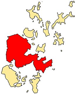
The Pentland Skerries (Old Norse: Pettlandssker) [1] are a group of four uninhabited islands lying in the Pentland Firth, northeast of Duncansby Head and south of South Ronaldsay in Scotland.
By far the largest of the islands is Muckle Skerry, home to two lighthouses, built in 1794. The other islands lie to the south of Muckle Skerry. From west to east, they are Little Skerry, Louther Skerry and Clettack Skerry.
MV Priscilla ran aground on Pentland Skerries on 18 July 2018. [2]

The Pentland Firth is a strait which separates the Orkney Islands from Caithness in the north of Scotland. Despite the name, it is not a firth.
The Mainland, also known as Hrossey and Pomona, is the main island of Orkney, Scotland. Both of Orkney's burghs, Kirkwall and Stromness, lie on the island, which is also the heart of Orkney's ferry and air connections.
Papa Little is an island in St Magnus Bay, Shetland, Scotland.

Out Stack or Ootsta is an island in Shetland, Scotland and the northernmost point of both Scotland and the British Isles.

Hyskeir or Heyskeir is a low-lying rocky islet in the Inner Hebrides, Scotland. The Hyskeir Lighthouse marks the southern entrance to the Minch.

Muckle Skerry is the largest of the Pentland Skerries that lie off the north coast of Scotland. It is home to the Pentland Skerries Lighthouse.

Yell Sound is the strait running between Yell and Mainland, Shetland, Scotland. It is the boundary between the Mainland and the North Isles and it contains many small islands. Sullom Voe, on the shores of which is a substantial oil terminal, is an arm of Yell Sound.

Holm is a parish on Mainland, Orkney.
This is a list of the extreme points and extreme elevations in Scotland.
Campaigh or Campay is a steep and rocky islet in outer Loch Ròg, Lewis, Scotland that lies north of Cealasaigh and Little Bernera.
Flodaigh is an islet in outer Loch Ròg, Lewis, Scotland. It lies north west of Great Bernera and Little Bernera, south of Bearasaigh and Seanna Chnoc and west of Campaigh.
Events from the year 1884 in Scotland.

St Magnus Bay is a large coastal feature in the north-west of Mainland Shetland, Scotland. Roughly circular in shape with a diameter of about 19 kilometres (12 mi), it is open to the North Atlantic Ocean to the west. The indented coastline to the north, south and east between Esha Ness in the north and the Ness of Melby in the south contains numerous bays, firths and voes and there are several islands around the perimeter. The waters of the bay are up to 165 metres (541 ft) deep and may have been the site of a substantial meteor impact.
The Cemfjord was a Cyprus-registered cargo ship which foundered in the Pentland Firth off the north-east coast of Scotland on 2 January 2015. Built as the general cargo ship Margareta in 1984, she was converted to carry cement in 1998 and was en route from Aalborg, Denmark to Runcorn, Cheshire, United Kingdom when she capsized in bad weather and sank in 82 metres (270 ft) of water. All eight crew were presumed lost. No bodies were recovered, and the ship has been left as a sea grave.
Events from the year 1794 in Scotland.
Muckle may refer to:
| Wikimedia Commons has media related to Pentland Skerries . |
Coordinates: 58°40′54″N2°54′50″W / 58.68167°N 2.91389°W
| | This Orkney location article is a stub. You can help Wikipedia by expanding it. |