
A sinkhole is a depression or hole in the ground caused by some form of collapse of the surface layer. The term is sometimes used to refer to doline, enclosed depressions that are also known as shakeholes, and to openings where surface water enters into underground passages known as ponor, swallow hole or swallet. A cenote is a type of sinkhole that exposes groundwater underneath. Sink and stream sink are more general terms for sites that drain surface water, possibly by infiltration into sediment or crumbled rock.
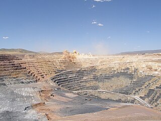
Open-pit mining, also known as open-cast or open-cut mining and in larger contexts mega-mining, is a surface mining technique that extracts rock or minerals from the earth.

A septic tank is an underground chamber made of concrete, fiberglass, or plastic through which domestic wastewater (sewage) flows for basic sewage treatment. Settling and anaerobic digestion processes reduce solids and organics, but the treatment efficiency is only moderate. Septic tank systems are a type of simple onsite sewage facility. They can be used in areas that are not connected to a sewerage system, such as rural areas. The treated liquid effluent is commonly disposed in a septic drain field, which provides further treatment. Nonetheless, groundwater pollution may occur and is a problem.

Groundwater is the water present beneath Earth's surface in rock and soil pore spaces and in the fractures of rock formations. About 30 percent of all readily available freshwater in the world is groundwater. A unit of rock or an unconsolidated deposit is called an aquifer when it can yield a usable quantity of water. The depth at which soil pore spaces or fractures and voids in rock become completely saturated with water is called the water table. Groundwater is recharged from the surface; it may discharge from the surface naturally at springs and seeps, and can form oases or wetlands. Groundwater is also often withdrawn for agricultural, municipal, and industrial use by constructing and operating extraction wells. The study of the distribution and movement of groundwater is hydrogeology, also called groundwater hydrology.

In physics, chemistry, and materials science, percolation refers to the movement and filtering of fluids through porous materials. It is described by Darcy's law. Broader applications have since been developed that cover connectivity of many systems modeled as lattices or graphs, analogous to connectivity of lattice components in the filtration problem that modulates capacity for percolation.

Hydrogeology is the area of geology that deals with the distribution and movement of groundwater in the soil and rocks of the Earth's crust. The terms groundwater hydrology, geohydrology, and hydrogeology are often used interchangeably, though hydrogeology is the most commonly used.

Cesspit, cesspool and soak pit in some contexts are terms with various meanings: they are used to describe either an underground holding tank or a soak pit. A cesspit can be used for the temporary collection and storage of feces, excreta, or fecal sludge as part of an on-site sanitation system and has some similarities with septic tanks or with soak pits. Traditionally, it was a deep cylindrical chamber dug into the ground, having approximate dimensions of 1 metre (3') diameter and 2–3 metres depth. Its appearance was similar to that of a hand-dug water well.

A pit latrine, also known as pit toilet, is a type of toilet that collects human waste in a hole in the ground. Urine and feces enter the pit through a drop hole in the floor, which might be connected to a toilet seat or squatting pan for user comfort. Pit latrines can be built to function without water or they can have a water seal. When properly built and maintained, pit latrines can decrease the spread of disease by reducing the amount of human feces in the environment from open defecation. This decreases the transfer of pathogens between feces and food by flies. These pathogens are major causes of infectious diarrhea and intestinal worm infections. Infectious diarrhea resulted in about 700,000 deaths in children under five years old in 2011 and 250 million lost school days. Pit latrines are a low-cost method of separating feces from people.
In hydrology, there are two similar but distinct definitions in use for the word drawdown:
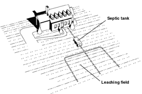
Septic drain fields, also called leach fields or leach drains, are subsurface wastewater disposal facilities used to remove contaminants and impurities from the liquid that emerges after anaerobic digestion in a septic tank. Organic materials in the liquid are catabolized by a microbial ecosystem.
The United States Environmental Protection Agency (EPA) Storm Water Management Model (SWMM) is a dynamic rainfall–runoff–subsurface runoff simulation model used for single-event to long-term (continuous) simulation of the surface/subsurface hydrology quantity and quality from primarily urban/suburban areas.

Drill cuttings are broken bits of solid material removed from a borehole drilled by rotary, percussion, or auger methods and brought to the surface in the drilling mud. Boreholes drilled in this way include oil or gas wells, water wells, and holes drilled for geotechnical investigations or mineral exploration.

Geotechnical investigations are performed by geotechnical engineers or engineering geologists to obtain information on the physical properties of soil earthworks and foundations for proposed structures and for repair of distress to earthworks and structures caused by subsurface conditions; this type of investigation is called a site investigation. Geotechnical investigations are also used to measure the thermal resistance of soils or backfill materials required for underground transmission lines, oil and gas pipelines, radioactive waste disposal, and solar thermal storage facilities. A geotechnical investigation will include surface exploration and subsurface exploration of a site. Sometimes, geophysical methods are used to obtain data about sites. Subsurface exploration usually involves soil sampling and laboratory tests of the soil samples retrieved.

Groundwater recharge or deep drainage or deep percolation is a hydrologic process, where water moves downward from surface water to groundwater. Recharge is the primary method through which water enters an aquifer. This process usually occurs in the vadose zone below plant roots and is often expressed as a flux to the water table surface. Groundwater recharge also encompasses water moving away from the water table farther into the saturated zone. Recharge occurs both naturally and through anthropogenic processes, where rainwater and/or reclaimed water is routed to the subsurface.

Soil salinity control refers to controlling the process and progress of soil salinity to prevent soil degradation by salination and reclamation of already salty (saline) soils. Soil reclamation is also known as soil improvement, rehabilitation, remediation, recuperation, or amelioration.
A mound system is an engineered drain field for treating wastewater in places with limited access to multi-stage wastewater treatment systems. Mound systems are an alternative to the traditional rural septic system drain field. They are used in areas where septic systems are prone to failure from extremely permeable or impermeable soils, soil with the shallow cover over porous bedrock, and terrain that features a high water table.

A well is an excavation or structure created in the earth by digging, driving, or drilling to access liquid resources, usually water. The oldest and most common kind of well is a water well, to access groundwater in underground aquifers. The well water is drawn up by a pump, or using containers, such as buckets or large water bags that are raised mechanically or by hand. Water can also be injected back into the aquifer through the well. Wells were first constructed at least eight thousand years ago and historically vary in construction from a simple scoop in the sediment of a dry watercourse to the qanats of Iran, and the stepwells and sakiehs of India. Placing a lining in the well shaft helps create stability, and linings of wood or wickerwork date back at least as far as the Iron Age.
A leaching model is a hydrological model by which the leaching with irrigation water of dissolved substances, notably salt, in the soil is described depending on the hydrological regime and the soil's properties.
In between November 2013 to 2017, more than 200 sinkholes were formed in the Armala area of Pokhara. The sinkholes were formed mostly in the paddy fields in the alluvial fan deposit. The sinkholes terrorised and displaced hundreds of local residents.

Herman Bouwer (1927–2013) was a hydrological scientist who worked in groundwater hydrology and water resources management, with a specialization in the area of Managed Aquifer Recharge (MAR). He was born in the Netherlands and moved to the United States in 1952 to study for his PhD at Cornell University. He went on to work at the U.S. Water Conservation Laboratory, U.S. Dept. of Agriculture, serving as director from 1972 to 1990. His research efforts on characterizing and modeling the movement of water and pollutants in the vadose zone and groundwater resulted in field and analytical methods that are used in the groundwater sciences. He authored or co-authored over 300 publications and wrote the textbook Groundwater Hydrology.
