Related Research Articles

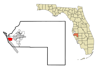
Manatee County is a county in the U.S. state of Florida. As of the 2020 US Census, the population was 399,710. Manatee County is part of the North Port-Bradenton-Sarasota, Florida Metropolitan Statistical Area. Its county seat and largest city is Bradenton. The county was created in 1855 and named for the Florida manatee, Florida's official marine mammal. Features of Manatee County include access to the southern part of the Tampa Bay estuary, the Sunshine Skyway Bridge, and the Manatee River.
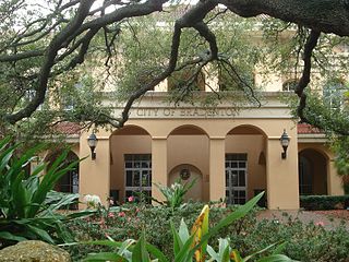
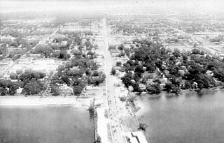
Bradenton is a city in and the county seat of Manatee County, Florida, United States. As of the 2020 census, the city's population is 55,698, up from 49,546 at the 2010 census. It is a principal city in the North Port-Bradenton-Sarasota, Florida Metropolitan Statistical Area. Downtown Bradenton is along the Manatee River and includes the Bradenton Riverwalk. Downtown Bradenton is also home to the Bishop Museum of Science and Nature.
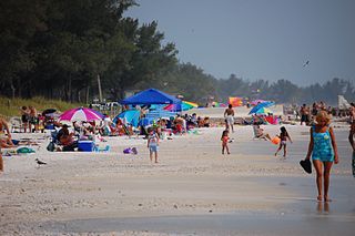
Bradenton Beach is a city on Anna Maria Island in Manatee County, Florida, United States. The population was 908 at the 2020 census, down from 1,171 in 2010. It is part of the North Port-Bradenton-Sarasota, Florida Metropolitan Statistical Area.
Cortez, a census-designated place (CDP) in Manatee County, Florida, United States, is a small Gulf Coast commercial fishing village that was founded by settlers from North Carolina in the 1880s. The population was 4,121 at the 2020 census, down from 4,241 at the 2010 census. It is part of the North Port-Bradenton-Sarasota, Florida Metropolitan Statistical Area.
Palmetto is a city in Manatee County, Florida, United States. As of the 2020 census, the population was listed as 13,323, up from 12,606 at the 2010 census. It is part of the North Port–Bradenton–Sarasota, Florida Metropolitan Statistical Area.

West Bradenton is an unincorporated area and census-designated place (CDP) in Manatee County, Florida, United States. The population was 4,247 at the 2020 census, up from 4,192 at the 2010 census. It is part of the North Port–Bradenton–Sarasota, Florida Metropolitan Statistical Area.
Manatee High School is the oldest public high school in Bradenton, Florida, operated by the Manatee County School District.
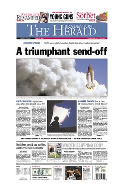
The Bradenton Herald is a newspaper based in Bradenton, Florida, in the United States.

State Road 64 extends from City Road 789 near the Gulf of Mexico in Holmes Beach on Anna Maria Island in Manatee County to US 27/US 98 in Avon Park in Highlands County. State Road 64 travels from west to east through the counties of Manatee, Hardee and Highlands. It is a mostly rural two-lane highway going through only two cities, Bradenton and Zolfo Springs. It crosses the Gulf Intracoastal Waterway as well as the Braden River, Lake Manatee, and the Myakka River. East of Avon Park, a bi-county extension runs northeast into Polk County which runs through Lake Wales Ridge State Forest and terminates at the Avon Park US Air Force Base. It is designated as the Florida Cracker Trail from Bradenton to the Hardee County Line.

Anna Maria Island, is a barrier island on the coast of Manatee County, Florida, in the United States. It is bounded on the west by the Gulf of Mexico, on the south by Longboat Pass, on the east by Anna Maria Sound, and on the north by Tampa Bay. Anna Maria Island is approximately 7 miles (11 km) long north to south.
Myakka City is an unincorporated community in southeastern Manatee County, Florida, United States. It lies along State Road 70 near the city of Bradenton, the county seat of Manatee County. Its elevation is 43 feet (13 m), and it is located at 27°20′59″N82°9′41″W. Although Myakka is unincorporated, it has a post office, with the ZIP code of 34251; the ZCTA for ZIP code 34251 had a population of 6,351 at the 2010 census. up from 4,239 in 2000.
The Tampa Southern Railroad was a subsidiary of the Atlantic Coast Line Railroad (ACL) originally running from Uceta Yard in Tampa south to Palmetto, Bradenton, and Sarasota with a later extension southeast to Fort Ogden in the Peace River valley built shortly after. It was one of many rail lines completed during the Florida land boom of the 1920s. Most of the remaining trackage now serves as CSX Transportation's Palmetto Subdivision. Another short portion just east of Sarasota also remains that is now operated by Seminole Gulf Railway.
Palma Sola is an unincorporated area of Manatee County, Florida, United States. The botanical garden in Bradenton, Florida is known as the Palma Sola Botanical Garden.
Fort Hamer is an unincorporated area in Manatee County, Florida, United States, and was the name of a short-lived U.S. Army fort in eastern Manatee County. Although the area is named for Fort Hamer, the former military installation has never been precisely located through historical or archaeological research.
Oak Knoll is an unincorporated area in Manatee County, Florida, in the United States.
Cedar Hammock is an unincorporated area in Manatee County, Florida, in the United States. Flanked by Bradenton to the north and Oneco to the south, Cedar Hammock was a hardwood hammock which became a popular location for truck farming in the early 20th century.
Sandy is an unincorporated area in Manatee County, Florida, United States. The community was previously known as Sandy Branch and Stephen.
Parmalee, Florida was a short-lived town and stop on the East and West Coast Railway in Manatee County, Florida, United States. Located at the modern day intersection of Betts Road and State Road 70, the area remains largely undeveloped or agricultural.
Ilexhurst is a subdivision and former resort community on Anna Maria Island in Manatee County, Florida, United States. It is part of the Bradenton–Sarasota–Venice Metropolitan Statistical Area. The subdivision occupies the central part of Anna Maria Island. From 1953 to 1954, the community was split and annexed into the adjacent cities of Holmes Beach and Bradenton Beach.
The Seaboard Air Line Railroad's Sarasota Subdivision was a rail line that ran from the company's main line at Turkey Creek south to Palmetto, Bradenton, Sarasota, and Venice. The line was built in phases from 1901 to 1911.
References
- ↑ "Perico". Manatee County Public Library System: Digital Collection. Retrieved July 17, 2022.
- ↑ Beale, John (February 9, 2016). "Cuban fishermen set up ranchos in Manatee". Florida Maritime Museum. Retrieved December 16, 2020.
- ↑ Stack, Margaret (2011). An Archaeological and Archival Appraisal of "Spanish Indians" on the West Coast of Florida in the Eighteenth and Nineteenth Centuries. University of South Florida. p. 37.
- ↑ "28 Oct 1956, 71 - The Tampa Tribune at Newspapers.com". Newspapers.com. Retrieved 2020-12-16.
- ↑ Goggin, John M. (July 1950). "An Early Lithic Complex from Central Florida". American Antiquity. 16 (1): 46–49. doi:10.2307/276339. ISSN 0002-7316. JSTOR 276339. S2CID 161517086.
- ↑ U.S., Appointments of U. S. Postmasters, 1832-1971.
- ↑ "Bradentown Manatee River Journal Archives, Feb 2, 1893, p. 3". NewspaperArchive.com. 1893-02-02. Retrieved 2020-12-16.
- ↑ "26 Nov 1908, 2 - The Tampa Tribune at Newspapers.com". Newspapers.com. Retrieved 2020-12-16.
- ↑ "Bradentown Manatee River Journal News Archives, Jan 25, 1900, p. 3". NewspaperArchive.com. 1900-01-25. Retrieved 2020-12-16.
- ↑ "Bradentown Manatee River Journal Archives, Sep 18, 1913, p. 9". NewspaperArchive.com. 1913-09-18. Retrieved 2020-12-16.
- ↑ "Bradentown Manatee River Journal Archives, May 8, 1903, p. 8". NewspaperArchive.com. 1903-05-08. Retrieved 2020-12-16.
- ↑ "Bradentown Manatee River Journal Archives, Dec 24, 1914, p. 9". NewspaperArchive.com. 1914-12-24. Retrieved 2020-12-16.
- ↑ "Bradentown Manatee River Journal Archives, Aug 26, 1920, p. 1". NewspaperArchive.com. 1920-08-26. Retrieved 2020-12-16.
- ↑ "Bradenton Evening Herald Archives, Sep 18, 1922, p. 1". NewspaperArchive.com. 1922-09-18. Retrieved 2020-12-16.
- ↑ "19 Mar 2000, 32 - The Tampa Tribune at Newspapers.com". Newspapers.com. Retrieved 2020-12-16.
Municipalities and communities of Manatee County, Florida, United States | ||
|---|---|---|
| Cities |  | |
| Town | ||
| CDPs | ||
| Unincorporated communities | ||
| Ghost towns | ||
| Footnotes | ‡This populated place also has portions in an adjacent county or counties | |