
The Permian Basin is a large sedimentary basin in the southwestern part of the United States. The basin contains the Mid-continent oil field province. This sedimentary basin is located in western Texas and southeastern New Mexico. It reaches from just south of Lubbock, past Midland and Odessa, south nearly to the Rio Grande River in southern West Central Texas, and extending westward into the southeastern part of New Mexico. It is so named because it has one of the world's thickest deposits of rocks from the Permian geologic period. The greater Permian Basin comprises several component basins; of these, the Midland Basin is the largest, Delaware Basin is the second largest, and Marfa Basin is the smallest. The Permian Basin covers more than 86,000 square miles (220,000 km2), and extends across an area approximately 250 miles (400 km) wide and 300 miles (480 km) long.
The Zechstein is a unit of sedimentary rock layers of Late Permian (Lopingian) age located in the European Permian Basin which stretches from the east coast of England to northern Poland. The name Zechstein was formerly also used as a unit of time in the geologic timescale, but nowadays it is only used for the corresponding sedimentary deposits in Europe.
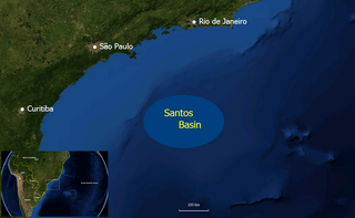
The Santos Basin is an approximately 352,000 square kilometres (136,000 sq mi) large mostly offshore sedimentary basin. It is located in the south Atlantic Ocean, some 300 kilometres (190 mi) southeast of Santos, Brazil. The basin is one of the Brazilian basins to have resulted from the break-up of Gondwana since the Early Cretaceous, where a sequence of rift basins formed on both sides of the South Atlantic; the Pelotas, Santos, Campos and Espírito Santo Basins in Brazil, and the Namibia, Kwanza and Congo Basins in southwestern Africa.

The Paradox Basin is an asymmetric foreland basin located mostly in southeast Utah and southwest Colorado, but extending into northeast Arizona and northwest New Mexico. The basin is a large elongate northwest to southeast oriented depression formed during the late Paleozoic Era. The basin is bordered on the east by the tectonically uplifted Uncompahgre Plateau, on the northwest by the San Rafael Swell and extends partway into the Monument Uplift to the west.
The Rotliegend, Rotliegend Group or Rotliegendes is a lithostratigraphic unit of latest Carboniferous to Guadalupian age that is found in the subsurface of large areas in western and central Europe. The Rotliegend mainly consists of sandstone layers. It is usually covered by the Zechstein and lies on top of regionally different formations of late Carboniferous age.
The Buntsandstein or Bunter sandstone is a lithostratigraphic and allostratigraphic unit in the subsurface of large parts of west and central Europe. The Buntsandstein predominantly consists of sandstone layers of the Lower Triassic series and is one of three characteristic Triassic units, together with the Muschelkalk and Keuper that form the Germanic Trias Supergroup.
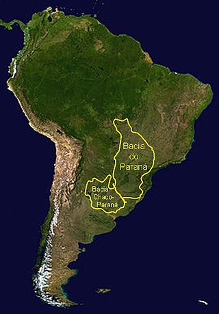
The Paraná Basin is a large cratonic sedimentary basin situated in the central-eastern part of South America. About 75% of its areal distribution occurs in Brazil, from Mato Grosso to Rio Grande do Sul states. The remainder area is distributed in eastern Paraguay, northeastern Argentina and northern Uruguay. The shape of the depression is roughly elliptical and covers an area of about 1,500,000 km2 (580,000 sq mi).
The Manitoba Group is a stratigraphical unit of middle to late Devonian age in the Western Canadian Sedimentary Basin.

The Pyrenees are a 430-kilometre-long, roughly east–west striking, intracontinental mountain chain that divide France, Spain, and Andorra. The belt has an extended, polycyclic geological evolution dating back to the Precambrian. The chain's present configuration is due to the collision between the microcontinent Iberia and the southwestern promontory of the European Plate. The two continents were approaching each other since the onset of the Upper Cretaceous (Albian/Cenomanian) about 100 million years ago and were consequently colliding during the Paleogene (Eocene/Oligocene) 55 to 25 million years ago. After its uplift, the chain experienced intense erosion and isostatic readjustments. A cross-section through the chain shows an asymmetric flower-like structure with steeper dips on the French side. The Pyrenees are not solely the result of compressional forces, but also show an important sinistral shearing.
The Tambach Formation is an Early Permian-age geologic formation in central Germany. It consists of red to brown-colored sedimentary rocks such as conglomerate, sandstone, and mudstone, and is the oldest portion of the Upper Rotliegend within the Thuringian Forest Basin.

The Kupferschiefer or Kupfermergel, is an extensive and remarkable sedimentary unit in Central Europe. The relatively monotonous succession is typically 30 to 60 centimetres and maximum 2 metres (6.6 ft) thick, but extends over an area of 600,000 square kilometres (230,000 sq mi) across the Southern Permian Basin. The Kupferschiefer can be found in outcrop or in the subsurface straddling six countries, including parts of the southern North Sea. The lateral equivalent outcropping in England is called Marl Slate.

The North Sea basin is located in northern Europe and lies between the United Kingdom, and Norway just north of The Netherlands and can be divided into many sub-basins. The Southern North Sea basin is the largest gas producing basin in the UK continental shelf, with production coming from the lower Permian sandstones which are sealed by the upper Zechstein salt. The evolution of the North Sea basin occurred through multiple stages throughout the geologic timeline. First the creation of the Sub-Cambrian peneplain, followed by the Caledonian Orogeny in the late Silurian and early Devonian. Rift phases occurred in the late Paleozoic and early Mesozoic which allowed the opening of the northeastern Atlantic. Differential uplift occurred in the late Paleogene and Neogene. The geology of the Southern North Sea basin has a complex history of basinal subsidence that had occurred in the Paleozoic, Mesozoic, and Cenozoic. Uplift events occurred which were then followed by crustal extension which allowed rocks to become folded and faulted late in the Paleozoic. Tectonic movements allowed for halokinesis to occur with more uplift in the Mesozoic followed by a major phase of inversion occurred in the Cenozoic affecting many basins in northwestern Europe. The overall saucer-shaped geometry of the southern North Sea Basin indicates that the major faults have not been actively controlling sediment distribution.

The North German Basin is a passive-active rift basin located in central and west Europe, lying within the southeasternmost portions of the North Sea and the southwestern Baltic Sea and across terrestrial portions of northern Germany, Netherlands, and Poland. The North German Basin is a sub-basin of the Southern Permian Basin, that accounts for a composite of intra-continental basins composed of Permian to Cenozoic sediments, which have accumulated to thicknesses around 10–12 kilometres (6–7.5 mi). The complex evolution of the basin takes place from the Permian to the Cenozoic, and is largely influenced by multiple stages of rifting, subsidence, and salt tectonic events. The North German Basin also accounts for a significant amount of Western Europe's natural gas resources, including one of the world's largest natural gas reservoir, the Groningen gas field.
The Prairie Evaporite Formation, also known as the Prairie Formation, is a geologic formation of Middle Devonian (Givetian) age that consists primarily of halite and other evaporite minerals. It is present beneath the plains of northern and eastern Alberta, southern Saskatchewan and southwestern Manitoba in Canada, and it extends into northwestern North Dakota and northeastern Montana in the United States.
The North Patagonian Massif or Somún Cura Massif is a massif in northern Patagonia located in the Argentine provinces of Río Negro and Chubut. The massif is a plateau surrounded by sedimentary basins. The North Patagonian Massif covers an area of approximately 100,000 square kilometres (39,000 sq mi). The massif rises 500 to 700 metres above the surrounding topography reaching a maximum of 1,200 metres (3,900 ft) above sea level. Compared to neighboring areas, the North Patagonian Massif has thicker continental crust.

The geology of Germany is heavily influenced by several phases of orogeny in the Paleozoic and the Cenozoic, by sedimentation in shelf seas and epicontinental seas and on plains in the Permian and Mesozoic as well as by the Quaternary glaciations.

The geology of Uzbekistan consists of two microcontinents and the remnants of oceanic crust, which fused together into a tectonically complex but resource rich land mass during the Paleozoic, before becoming draped in thick, primarily marine sedimentary units.
The geology of Iraq includes thick sequences of marine and continental sedimentary rocks over poorly understood basement rock, at the junction of the Arabian Plate, the Anatolian Plate, and the Iranian Plate.

The Rub' al Khali Basin or ar-Rubʻ al-Khālī / ar-rubʿ al-ḵālī Basin, Arabic for "Empty Quarter Basin", is a major endorheic sedimentary basin of approximately 560,000 square kilometres (220,000 sq mi) in southern Saudi Arabia, northeastern Yemen, southeastern Oman and southeasternmost United Arab Emirates. The onshore foreland on Mesozoic rift basin is geographically defined by the eponymous Rub' al Khali and covers the regions of Najran and Riyadh and the Eastern Province. The basin is geologically bound by the Central Arabian Arch in the north, the Oman Thrust in the east, the Northern Hadramaut Arch in the south, and the Arabian Shield in the west. Politically, the southwestern boundary is formed by the border with Yemen and the border with Oman forms the southeastern boundary.
The Officer Basin is an intracratonic sedimentary basin that covers roughly 320,000 km2 along the border between southern and western Australia. Exploration for hydrocarbons in this basin has been sparse, but the geology has been examined for its potential as a hydrocarbon reservoir. This basin's extensive depositional history, with sedimentary thicknesses exceeding 6 km and spanning roughly 350 Ma during the Neoproterozoic, make it an ideal candidate for hydrocarbon production.
