Related Research Articles
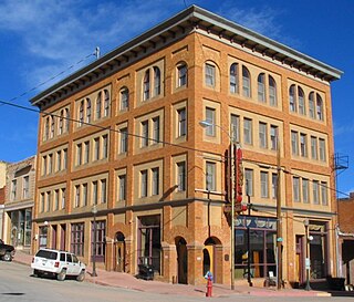
The City of Victor is a Statutory City in Teller County, Colorado, United States. Gold was discovered in Victor in the late 19th century, an omen of the future of the town. With Cripple Creek, the mining district became the second largest gold mining district in the country and realized approximately $10 billion of mined gold in 2010 dollars. It reached its peak around the turn of the century when there were about 18,000 residents in the town. Depleted ore in mines, labor strife and the exodus of miners during World War I caused a steep decline in the city's economy, from which it has never recovered. The population was 397 at the 2010 census. There is a resumed mining effort on Battle Mountain.

Almaden Quicksilver County Park is a 4,163 acres (17 km²) park that includes the grounds of former mercury ("quicksilver") mines adjacent to south San Jose, California, USA. The park's elevation varies greatly: the most used entrances are less than 600 feet above sea level, while the highest point in the park is over 1,700 feet above sea level.

Greenwood is a city in south central British Columbia. It was incorporated in 1897 and was formerly one of the principal cities of the Boundary Country smelting and mining district. It was incorporated as a city originally and has retained that title despite the population decline following the closure of the area's industries.

Sharon is an unincorporated community and coal town in southeastern Kanawha County, West Virginia, United States, located along the West Virginia Turnpike.

The Potosi mining district, or Potosi, was an area in Clark County of southern Nevada, U.S. It is listed on the National Register of Historic Places and includes three structures. The town was named after the famous silver-mining city of Potosi, Bolivia.
The Wild Horse River, formerly known as Wild Horse Creek, is a tributary of the Kootenay River, joining it near the town of Fort Steele, British Columbia, Canada. The river's canyon was the setting for the Wild Horse Creek Gold Rush and associated "war" during the gold rush of the mid-1860s.

Gold Rush is a reality television series that airs on Discovery and its affiliates worldwide. The series follows the placer gold mining efforts of various family-run mining companies, mostly in the Klondike region of Dawson City, Yukon, Canada. In its 11th season as of early 2020, prior seasons also included mining efforts in South America and western North America.
Bull River is a ghost town in the East Kootenay region of British Columbia, located on the east side of the Kootenay River at the mouth of the Bull River. The town was created in the 1860s when coarse placer gold was discovered in the Bull River. The town of Bull River and the river called Bull River were both named after a prospector named Bull who had mined placer along the river called Bull River. The gold disappeared after the turn of the century. Lumber and tie operations in the area kept the town alive after the gold boom ended. The town of Bull River had a hotel called Bull River hotel and a general store. Eventually Bull River was abandoned. Several buildings could be seen on the Bull River site in 1973.
Siwash Creek is a creek which is located in the Similkameen region of British Columbia. The creek flows into Hayes Creek approximately 3 miles (4.8 km) west of Jellicoe and 20 miles (32 km) northeast of Princeton, British Columbia. Siwash Creek has been mined for gold. The word is considered by some to be derisive, but remains in use in certain place names and other contexts without derogatory associations such as Siwash sweater. Nashwito Creek has also been referred to as Siwash Creek.
Pass Creek is a creek located in the Boundary Country region of British Columbia. This creek flows into the Granby River 11 miles north of Grand Forks, British Columbia. Pass Creek has been mined for gold.
Rock Creek is a creek in the Boundary Country region of British Columbia. This creek is the most renowned placer gold creek in the Boundary Country. It was discovered in 1859 by a Canadian named Adam Beam. Rock Creek was originally called York Creek. Beam earned $977 in the first six weeks he worked on the creek. It has been estimated that over $250,000 in placer gold was recovered from this creek. The creek contained two types of gold. One was lemon yellow and the other coppery gold. The largest nugget recovered from Rock Creek was valued at $150. The creek was worked extensively from 1860 to 1864 with 500 miners on its banks. Rock Creek was worked again in the 1890s and 1930s. It was mined by both Europeans and Chinese. It was a rich creek for miles of its length. Rock Creek is in the traditional territory of Sinixt people.
Findlay Creek is a creek in the East Kootenay region of British Columbia. This creek flows into the Kootenay River from the western side. Findlay Creek is located to the south of Canal Flats. The creek was discovered in 1863 by a native named Findlay. This creek has been mined by Europeans and Chinese miners.
Palmer Bar Creek is a creek in the East Kootenay region of British Columbia. This creek is a tributary of the Moyie River and discovered in the 1860s. Palmer Bar Creek has been mined for gold.
Weaver Creek is a creek located in the East Kootenay region of British Columbia. Weaver Creek is a tributary of the Moyie River. The creek has been mined for gold.
Lorne Creek is a creek located in the Omineca Country region of British Columbia. This creek flows into the Skeena River from the west and is located between Terrace and Hazleton, approximately 3 miles north of Doreen. Henry McDame discovered gold in this creek back in 1884. The creek has been mined for gold.
Foster Coulee is a coulee in Douglas County, Washington. Like the larger Moses Coulee nearby, it was formed during the Missoula Floods at the end of the last ice age, some 14,000 years ago.
San Felipe Creek is a stream in Imperial and San Diego Counties of California. It arises in the Volcan Mountains of San Diego County 33°11′57″N116°37′35″W, and runs eastward, gathering the waters of most of the eastern slope of the mountains and desert of the county before it empties into the Salton Sea. It is probably the last remaining perennial natural desert stream in the Colorado Desert region. In 1974, the San Felipe Creek Area was designated as a National Natural Landmark by the National Park Service.
Millertown is an unincorporated community in Perry County, in the U.S. state of Ohio.
Tumco Mine was a former gold mine in the Cargo Muchacho Mountains of Imperial County, California.
Boston is an unincorporated community in the Boston Mountains of southeastern Madison County, Arkansas, United States. The community is located on Arkansas Highway 16 between Pettigrew to the southwest and Red Star to the northeast. The community is on a high ridge at an elevation of 2,329 feet (710 m). The location is at the headwaters of four streams: Kings River to the northeast, War Eagle Creek to the northwest, the White River to the east and southwest and Little Mulberry Creek to the southeast.
References
- ↑ N.L. Barlee (1973), Gold Creeks and Ghost Towns. Canada West Publications.