Phakding

Last updated
Phadking
Trail exiting the village of Phakding..jpg
Trail exiting the village of Phakding leading to Lukla.
Nepal Koshi adm location map.svg
Red pog.svg
Phadking
Location in Nepal
Nepal adm location map.svg
Red pog.svg
Phadking
Phadking (Nepal)
Coordinates: 27°45′N86°43′E / 27.750°N 86.717°E / 27.750; 86.717
CountryFlag of Nepal.svg    Nepal
Province Province No. 1
District Solukhumbu District
Rural municipality Khumbu Pasanglhamu
Government
  TypeWard division
Elevation
2,610 m (8,560 ft)
Time zone UTC+5:45 (Nepal Time)
Area code 038

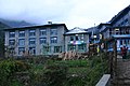
Phakding is a small village in the Khumbu region of Nepal. It lies in the Dudh Kosi river valley just north of Lukla and south of Monjo, at an altitude of 2,610 m, [1] [2] [3] one of the UNESCO World Heritage Site since 1979.

Contents

The trail starts at Lukla and Phakding is often the main stopping point for trekkers on their way to Mount Everest via the Gokyo Ri route or Tengboche route. [2]

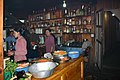
The primary function of the village is to support the tourism industry and as such consists of a number of guesthouses. [2]


Climate

Climate data for Phakding (Chaurikharka, elevation 2,619 m (8,593 ft))
MonthJanFebMarAprMayJunJulAugSepOctNovDecYear
Average high °C (°F)9.8
(49.6)
11.0
(51.8)
13.7
(56.7)
18.1
(64.6)
19.2
(66.6)
19.5
(67.1)
19.3
(66.7)
19.6
(67.3)
18.4
(65.1)
17.5
(63.5)
14.0
(57.2)
11.3
(52.3)
16.0
(60.7)
Average low °C (°F)−1.5
(29.3)
−0.2
(31.6)
3.0
(37.4)
6.1
(43.0)
8.3
(46.9)
11.3
(52.3)
12.2
(54.0)
11.7
(53.1)
10.6
(51.1)
7.1
(44.8)
2.3
(36.1)
−0.4
(31.3)
5.9
(42.6)
Average precipitation mm (inches)16
(0.6)
28
(1.1)
51
(2.0)
80
(3.1)
106
(4.2)
310
(12.2)
566
(22.3)
531
(20.9)
303
(11.9)
92
(3.6)
14
(0.6)
9
(0.4)
2,106
(82.9)
Source 1: ANU [4]
Source 2: WWF Nepal (precipitation) [5]

See also

Related Research Articles

<span class="mw-page-title-main">Lukla</span> Town in Province No. 1, Nepal

Lukla is a small town in the Khumbu Pasanglhamu rural municipality of the Solukhumbu District in the Province No. 1 of north-eastern Nepal. Situated at 2,860 metres (9,383 ft), it is a popular place for visitors to the Himalayas near Mount Everest to arrive. Although Lukla means "place with many goats and sheep", few are found in the area nowadays.

<span class="mw-page-title-main">Jiri</span> Municipality in Bagmati, Nepal

Jiri is a municipality in Dolakha District in the Bagmati Province of central Nepal. At the time of the 2011 Nepal census it had a population of 13,638 people. Jiri, which lies about 190 kilometers from Kathmandu, is the main gateway to the Everest Region. Almost all the Everest expeditions, including the one led by famous climber John Hunt, Edmund Hillary had passed through Jiri. A company of the Nepal Army is stationed in town and visitors' equipment and backpacks might be searched. There are a number of lodges available along either side of the main road mainly in Jiri Bazaar.

<span class="mw-page-title-main">Tengboche</span> Place in Province No. 1, Nepal

Tengboche is a village in Khumbu Pasanglhamu rural municipality in the Khumbu subregion of Province No. 1 in Nepal, located at 3,867 metres (12,687 ft). Within the village is an important Buddhist monastery, Tengboche Monastery, which is the largest gompa in the Khumbu region. The structure was built in 1923. In 1934, it was destroyed by an earthquake but subsequently rebuilt. It was destroyed again by a fire in 1989, and again rebuilt with the help of volunteers and the provision of foreign aid. Tengboche has a panoramic view of the Himalayan mountains, including the well-known peaks of Tawache, Everest, Nuptse, Lhotse, Ama Dablam, and Thamserku. Tenzing Norgay, the first man to reach the summit of Mount Everest with Sir Edmund Hillary, was born in the area in the village of Thani and was once sent to Tengboche Monastery to be a monk.

<span class="mw-page-title-main">Khumbu</span>

Khumbu is a region of northeastern Nepal on the Nepalese side of Mount Everest. It is part of the Solukhumbu District, which in turn is part of Koshi Pradesh. Khumbu is one of three subregions of the main Kirat Kulung and Sherpa settlement of the Himalaya, the other two being Solu and Pharak. It includes the town of Namche Bazaar as well as the villages of Thame, Khumjung, Pangboche, Pheriche and Kunde. The famous Buddhist monastery at Tengboche is also located in the Khumbu.

<span class="mw-page-title-main">Khumjung</span> Former Village Development Committee in Nepal

Khumjung is a village in Khumbu Pasanglhamu rural municipality of Solukhumbu District in Province No. 1 of north-eastern Nepal. It is located in the Khumbu subregion inside Sagarmatha National Park, a world heritage site. The village is at an elevation of 3,790 metres above sea level, and is situated near Mount Khumbila.

<span class="mw-page-title-main">Gorakshep</span> Place

Gorak Shep or Gorakshep is a small settlement that sits on the edge of a frozen lakebed covered with sand in Nepal with the same name. It is found at an elevation of 5,164 metres (16,942 ft) elevation, near Mount Everest. The village is not inhabited year-round.

<span class="mw-page-title-main">Solukhumbu District</span> District in Koshi Province, Nepal

Solukhumbu District (Nepali: सोलुखुम्बु जिल्ला, Sherpa: ཤར་ཁུམ་བུ་རྫོང་།, Wylie: shar khum bu dzong) is one of 14 districts of Koshi Province of eastern Nepal. As the name suggests, it consists of the subregions Solu and Khumbu. The closest post office to Solukhumbu with a postal code assigned to it is the Sindhuli D.P.O., which has the postal code 56000.

<span class="mw-page-title-main">Dingboche</span> Place in Province No. 1, Nepal

Dingboche (दिङबोचे) 27°53′N86°49′E is a Sherpa village in the Khumbu region of north eastern Nepal in the Chukhung Valley. Its population was estimated at approximately 200 in 2011. It is situated at an altitude of 4,410 metres (14,470 ft).

<span class="mw-page-title-main">Tenzing-Hillary Airport</span> Airport in Lukla, Nepal

Tenzing-Hillary Airport, also known as Lukla Airport, is a domestic airport and altiport in the town of Lukla, in Khumbu Pasanglhamu, Solukhumbu District, Koshi Province of Nepal. It gained worldwide fame as it was rated the most dangerous airport in the world for more than 20 years by a program titled Most Extreme Airports, broadcast on The History Channel in 2010.

<span class="mw-page-title-main">Everest base camps</span> Staging areas for mountaineering activities on Mount Everest

There are two base camps on Mount Everest, on opposite sides of the mountains: South Base Camp is in Nepal at an altitude of 5,364 metres (17,598 ft), while North Base Camp is in China at 5,150 metres (16,900 ft).

<span class="mw-page-title-main">Chaurikharka</span> Village development committee in Sagarmatha Zone, Nepal

Chaurikharka is a village development committee in Solukhumbu District in the Sagarmatha Zone of northeastern Nepal. At the time of the 1991 Nepal census it had a population of 2422 people living in 502 individual households.

<span class="mw-page-title-main">Tengboche Monastery</span>

Tengboche Monastery, also known as Dawa Choling Gompa, in the Tengboche village in Khumjung in the Khumbu region of eastern Nepal is a Tibetan Buddhist monastery of the Sherpa community. Situated at 3,867 metres (12,687 ft), the monastery is the largest gompa in the Khumbu region of Nepal. It was built in 1916 by Lama Gulu with strong links to its mother monastery known as the Rongbuk Monastery in Tibet. In 1934, it was destroyed by an earthquake and was subsequently rebuilt. In 1989, it was destroyed for a second time by a fire and then rebuilt with the help of volunteers and international assistance.

<span class="mw-page-title-main">Imja Khola</span> River in Nepal

The Imja Khola is a tributary of the Dudh Kosi in Nepal. It drains the slopes of Mount Everest. The Khumbu Glacier melts into the Lobujya (Lobuche) River, which flows southward as the Imja Khola to its confluence with the Dudh Kosi at Tengboche.

<span class="mw-page-title-main">Monjo, Nepal</span> Village in Nepal

Monjo is a small village in the Khumbu region of Nepal. It lies in the Dudh Kosi river valley just north of Phakding and south of Jorsale, at an altitude of 2,835 m, just below the Sagarmatha National Park entrance gate and check-point, one of the UNESCO World Heritage Site since 1979.

<span class="mw-page-title-main">Jorsale</span> Village in the Khumbu region of Nepal

Jorsale is a small village in the Khumbu region of Nepal. It lies in the west side of the Dudh Kosi river, just north of Monjo and south of Namche Bazaar, at an altitude of 2,740 m,

<span class="mw-page-title-main">Kharta</span> Tibetan region east of Mount Everest

Kharta is a region in Tibet lying to the east of Mount Everest and centred on the Kharta valley and Kama valley. The 40-kilometre (25 mi) Kharta valley starts at the col at Lhakpa La at the head of the Kharta Glacier from which the Kharta Chu river flows east to join the Phung Chu just beyond Khata village. Nearby to the south, the Kama valley starts at the Kangshung Glacier at the foot of Everest's Kangshung Face, and the Kama Chu flows southeast to the Phung Chu. The 1921 British Mount Everest reconnaissance expedition discovered Kharta when reconnoitring ways to climb Mount Everest and managed to reach the North Col via the Lhakpa La. Since that time Kharta has not been used as a way to approach the summit of Everest but the two valleys have become a popular area for trekking.

<span class="mw-page-title-main">Lho La</span> Mountain pass near Mount Everest

The Lho La(Chinese: 洛拉山坳) is a col on the border between Nepal and Tibet north of the Western Cwm, near Mount Everest. It is at the lowest point of the West Ridge of the mountain at a height of 6,006 metres (19,705 ft). It is not exactly a Pass, but a part of Mt. Everest Range

<span class="mw-page-title-main">Lingtren</span> Himalayan mountain

Lingtren, 6,749 metres (22,142 ft), is a mountain in the Mahalangur Himal area of Himalaya, about 8 kilometres (5.0 mi) distant in a direct line from Mount Everest. It lies on the international border between Nepal and the Tibet Autonomous Region of China and it was first climbed in 1935. A mountain nearby to the west was originally named Lingtrennup but is now more commonly called Xi Lingchain.

<span class="mw-page-title-main">Khumbu Pasanglhamu Rural Municipality</span> Gaunpalika in Province No. 1, Nepal

Khumbu Pasanglhamu is a rural municipality (Gaunpalika) out of 7 rural municipalities located at Solukhumbu district of Province No. 1 of Nepal. Khumjung, Namche & Jubing and Chaurikharka were incorporated while creating it. It has the total population of 9,133 according to the 2011 Nepal census and area of 1,539.11 square kilometres (594.25 sq mi). The admin centre of this gaunpalika is that of the Chaurikharka.

Everest Link is an internet service provider founded in 2014 that provides high-speed internet and Wi-Fi in the remote Everest Region. It is the only internet provider at the Everest Base Camp, located at a height of 5,380m, making it the world's highest internet service. Before Everest Link was set up at the Base Camp, climbers solely relied on satellite phones for communication.

References

  1. Archived 2011-02-07 at the Wayback Machine Nepal Map Publisher Ltd.& ISBN   978-9937-8062-1-3;
  2. 1 2 3 Bradley, Mayhew; "Trekking in the Nepal Himalaya"; (2009); 9 ed.; p. 94 (map)+ pp 103-104; Lonely Planet; ISBN   9781741041880
  3. Bezruchka Stephen; "Trekking in the Nepal: a traveller’s guide"; The Mountaineers ed.; Seattle; (2004); page 220; ISBN   0-89886-535-2
  4. "CLIMATES OF NEPAL AND THEIR IMPLICATIONS FOR AGRICULTURAL DEVELOPMENT" (PDF). Australian National University. Archived from the original (PDF) on 23 October 2023. Retrieved 23 October 2023.
  5. "Integrated Study on Hydrology and Meteorology of Khumbu Region with Climate Change Perspectives" (PDF). WWF Nepal. Archived from the original (PDF) on 17 October 2023. Retrieved 24 October 2023.