
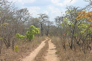
Veld, also spelled veldt, is a type of wide open rural landscape in Southern Africa. Particularly, it is a flat area covered in grass or low scrub, especially in the countries of South Africa, Lesotho, Eswatini, Zimbabwe and Botswana. A certain sub-tropical woodland ecoregion of Southern Africa has been officially defined as the Bushveld by the World Wide Fund for Nature. Trees are not abundant—frost, fire and grazing animals allow grass to grow but prevent the build-up of dense foliage.

Kruger National Park is a South African National Park and one of the largest game reserves in Africa. It covers an area of 19,623 km2 (7,576 sq mi) in the provinces of Limpopo and Mpumalanga in northeastern South Africa, and extends 360 km (220 mi) from north to south and 65 km (40 mi) from east to west. The administrative headquarters are in Skukuza. Areas of the park were first protected by the government of the South African Republic in 1898, and it became South Africa's first national park in 1926.

Gonarezhou National Park is a national park located in southeastern Zimbabwe. It is situated in a relatively remote corner of Masvingo Province, south of Chimanimani along the Mozambique border. Owing to its vast size, rugged terrain and its location away from main tourist routes, large tracts of Gonarezhou remain pristine wilderness.
Lephalale, also known as Ellisras, is a coal mining town in the Limpopo province of South Africa immediately east of the Waterberg Coalfield. The town was established as Ellisras in 1960 and named after Patrick Ellis and Piet Erasmus who settled on a farm there in the 1930s. In 2002, Ellisras was renamed Lephalale by the provincial government of Limpopo, after the main river that crosses the municipality. Lephalale is divided into three main subsections, Ellisras, Onverwacht and Marapong. Lephalale is derived from the setswana language meaning "to flow".
The Kingdom of Mapungubwe was a medieval state in South Africa located at the confluence of the Shashe and Limpopo rivers, south of Great Zimbabwe. The name is derived from either TjiKalanga and Tshivenda. The name might mean "Hill of Jackals" or "stone monuments". The kingdom was the first stage in a development that would culminate in the creation of the Kingdom of Zimbabwe in the 13th century, and with gold trading links to Rhapta and Kilwa Kisiwani on the African east coast. The Kingdom of Mapungubwe lasted about 80 years, and at its height the capital's population was about 5000 people.

The Soutpansberg, meaning "Salt Pan Mountain" in Afrikaans, is a range of mountains in far northern South Africa. It is located in Vhembe District, Limpopo. It is named for the salt pan located at its western end. The mountain range reaches the opposite extremity in the Matikwa Nature Reserve, some 107 kilometres (66 mi) due east. The range as a whole had no Venda name, as it was instead known by its sub-ranges which include Dzanani, Songozwi and others.
The Vhembe District Municipality is one of the 5 districts of the Limpopo province of South Africa. It is the northernmost district of the country and shares its northern border with the Beitbridge District in Zimbabwe and on the east with the Gaza Province in Mozambique. Vhembe consists of all the territories that were part of the former Venda Bantustan; however, two large densely populated districts of the former Tsonga homeland of Gazankulu, in particular, Hlanganani and Malamulele, were also incorporated into the municipality, hence the ethnic diversity of the district. The seat is Thohoyandou, the capital of the former Venda Bantustan. According to 2011 census, the majority of the municipality's 800,000 inhabitants spoke TshiVenda as their mother language, while 400,000 spoke Xitsonga as their home language. However, the Tsonga people form the majority south of the Levubu River, while the Venda are the minority south of Levubu at 15%. The Sepedi speakers number 27,000. The district code is DC34.

The wildlife of Mozambique consists of the flora and fauna of this country in southeastern Africa. Mozambique has a range of different habitat types and an ecologically rich and diverse wildlife. This includes 236 species of mammal, 740 species of bird and 5,692 species of vascular plant. The Maputaland-Pondoland-Albany hotspot, with significantly high levels of biodiversity, stretches from the southern tip of Mozambique into northeastern South Africa.

The Timbavati Private Nature Reserve is located at the border line between Hoedspruit and Acornhoek, north of the Sabi Sand Private Game Reserve on the western edge of Kruger National Park. Geographically and politically, Timbavati is located in Mpumalanga Province. In Xitsonga, the name 'Timbavati' means "the place where something sacred came down to Earth from the Heavens", and refers to the rare white lions of Timbavati.

Mapungubwe National Park is a national park in the Limpopo Province, South Africa. The park protects the historical site of Mapungubwe Hill, which was the capital of the Kingdom of Mapungubwe, as well as the wildlife and riverine forests along the Limpopo River. The Mapungubwe Hill was the site of a community dating back to the Iron Age. Evidence has shown that it was a prosperous community. Archaeologists also uncovered the famous Golden Rhinoceros of Mapungubwe figurine from the site.
The Venetia Limpopo Nature Reserve is situated in the northernmost parts of South Africa, and is owned by the De Beers Diamond Mining Company - the mine itself is actually within the confines of the reserve.

Greater Mapungubwe Transfrontier Conservation Area is a cultural TFCA, formerly known as the Limpopo–Shashe Transfrontier Conservation Area.

Balule Nature Reserve is a protected area in Limpopo Province, South Africa which forms part of the Greater Kruger National Park as a member of the Associated Private Nature Reserves (APNR). As part of a wildlife conservation initiative, all fences separating APNR reserves – Balule, Timbavati, Klaserie, Umbabat, – and the Kruger National Park have been removed.

Blouberg Nature Reserve is a protected area situated close to Vivo, west of Louis Trichardt in the Limpopo Province, of South Africa. It covers an area of 9,360 hectares from the eastern portion of the Blouberg mountain range to the savanna near the Brak River, and is founded by Peter Dix but was sold and now managed and administered by the Limpopo Provincial Government.
Lauren Liebenberg is a Zimbabwe-born South African writer. Her debut novel The Voluptuous Delights of Peanut Butter and Jam was nominated for the Orange Prize for Fiction in 2008. Her subsequent novels, The West Rand Jive Cats Boxing Club and Cry Baby, have also received international critical acclaim.
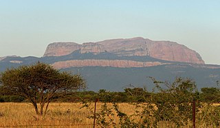
The Blouberg, meaning "Blue Mountain" in Dutch, is a range of mountains in the Limpopo Province, at the far north of South Africa. It is located in Blouberg Local Municipality, Capricorn District. The mountain is entrenched in the history of the local Northern Sotho people, and they have different names for its various parts.

The Zambezian and mopane woodlands is a tropical and subtropical grasslands, savannas, and shrublands ecoregion of southeastern Africa.
Mapesu Private Game Reserve is a game reserve in Limpopo Province, South Africa. The reserve adjoins the Mapungubwe National Park and World Heritage Site, with which it shares a 12.5 km Northern border. The main entrance gate to the reserve is located approximately 7 km east of Mapungubwe's entrance gate. It was established in 2014 and covers an area of over 7,200 hectares. The reserve protects various bird, mammal and tree species and is slated to become part of the Greater Mapungubwe Transfrontier Conservation Area in phase 2 as part of the proposed Limpopo Valley Game Reserve.
The Southern miombo woodlands is a tropical grasslands and woodlands ecoregion extending across portions of Malawi, Mozambique, Zambia, and Zimbabwe.
