Pho Chhu

Last updated
Pho Chhu
Mo Chhu.jpg
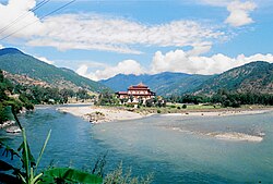
Confluence of the Mo Chhu (left) and the Pho Chhu (right)
Location
Country Bhutan
District Punakha
Physical characteristics
Source Tarina Tsho
  location Gasa District
Mouth Brahmaputra
Basin features
BridgesPho Chhu Suspension Bridge

Pho Chhu (Male River) is one of the major rivers of Bhutan, [1] which tracks its source in the Gasa District that borders Bhutan with Tibet, which joins with Mo Chhu (Female River) at the confluence below Punakha Dzong, the winter resident of Dratshang Lhentshog. Upon Dang Chhu joining below Wangdue Dzong, the trio flows as Puna Tsang Chhu and finally empties in the Brahmaputra, upon being joined by several tributaries on its course in the valley of Assam. Its source is susceptible to glaciers which even destroyed a part of Punakha Dzong. [2]

Related Research Articles

Geography of Bhutan

The Kingdom of Bhutan is a sovereign nation, located towards the eastern extreme of the Himalayas mountain range. It is fairly evenly sandwiched between the sovereign territory of two nations: first, the People's Republic of China on the north and northwest. There are approximately 477 kilometres of border with that nation's Tibet Autonomous Region. The second nation is the Republic of India on the south, southwest, and east; there are approximately 659 kilometres with the states of Arunachal Pradesh, Assam, West Bengal, and Sikkim, in clockwise order from the kingdom. Bhutan's total borders amount to 1,139 kilometres. The Republic of Nepal to the west, the India to the south, and the Union of Myanmar to the southeast are other close neighbours; the former two are separated by only very small stretches of Indian territory.

Dzong architecture Type of fortified monastery of Bhutan and Tibet

Dzong architecture is used for dzongs, a distinctive type of fortified monastery architecture found mainly in Bhutan and Tibet. The architecture is massive in style with towering exterior walls surrounding a complex of courtyards, temples, administrative offices, and monks' accommodation.

Wangdue Phodrang District District of Bhutan

Wangdue Phodrang District is a dzongkhag (district) of central Bhutan. This is also the name of the dzong which dominates the district, and the name of the small market town outside the gates of the dzong—it is the capital of Wangdue Phodrang District). The name is said to have been given by the Shabdrung Ngawang Namgyal who was searching for the best location for a dzong to prevent incursions from the south. The word "wangdue" means unification of Country, and "Phodrang" means Palace in Dzongkha.

Gasa District District of Bhutan

Gasa District or Gasa Dzongkhag is one of the 20 dzongkhags (districts) comprising Bhutan. The capital of Gasa District is Gasa Dzong near Gasa. It is located in the far north of the county and spans the Middle and High regions of the Tibetan Himalayas. The dominant language of the district is Dzongkha, which is the national language. Related languages, Layakha and Lunanakha, are spoken by semi-nomadic communities in the north of the district. The People's Republic of China claims the northern part of Gasa District.

Punakha District District of Bhutan

Punakha District is one of the 20 dzongkhags (districts) comprising Bhutan. It is bordered by Thimphu, Gasa, and Wangdue Phodrang Districts. The dominant language in the district is Dzongkha, the national language.

Articles related to Bhutan include:

Mo Chhu River in Bhutan

Mo Chhu is a major river in Bhutan. The word "Chhu" means "river" or "water" in Dzongkha, the official national language in Bhutan. The river rises in Gasa Dzongkhag (district) near the border between Bhutan and Tibet. From there, the Mo Chhu flows generally southward to Punakha in central Bhutan, where it joins the Pho Chhu from the northeast. The confluence of the two streams is immediately below the Punakha Dzong, which is the winter home of the Dratshang Lhentshog and the Je Khenpo. The combined streams are then joined by the Dang Chhu near the town of Wangdue Phodrang, and the name of the river becomes the Puna Tsang Chhu. The river then flows through Dagana and Tsirang Districts. After leaving Bhutan near the town of Lhamoidzingkha, formerly known as Kalikhola, the river enters Assam in India and is known as the Sankosh. The Sankosh ultimately empties into the Brahmaputra, flowing into the Bay of Bengal.

Sankosh River River in Bhutan and India

Sankosh is a river that rises in northern Bhutan and empties into the Brahmaputra in the state of Assam in India. In Bhutan, it is known as the Puna Tsang Chu below the confluences of several tributaries near the town of Wangdue Phodrang.

Punakha Administrative centre in Punakha dzongkhag, Bhutan

Punakha is the administrative centre of Punakha dzongkhag, one of the 20 districts of Bhutan. Punakha was the capital of Bhutan and the seat of government until 1955, when the capital was moved to Thimphu. It is about 72 km away from Thimphu, and it takes about 3 hours by car from the capital, Thimphu. Unlike Thimphu, it is quite warm in winter and hot in summer. It is located at an elevation of 1,200 metres above sea level, and rice is grown as the main crop along the river valleys of two main rivers of Bhutan, the Pho Chu and Mo Chu. Dzongkha is widely spoken in this district.

Wangdue Phodrang Place in Wangdue Phodrang District, Bhutan

Wangdue Phodrang is a town and capital of Wangdue Phodrang District in central Bhutan. It is located in Thedtsho Gewog.

Raidāk River Tributary of the Brahmaputra River in Bhutan, India, and Bangladesh

The Raidāk River, also called Wang Chhu or Wong Chhu in Bhutan, is a tributary of the River Brahmaputra, and a trans-boundary river. It flows through Bhutan, India and Bangladesh. It is one of the main river in Alipurduar District, India.

Jigme Dorji National Park National Park of Bhutan

The Jigme Dorji National Park (JDNP), named after the late Jigme Dorji Wangchuck, is the second-largest National Park of Bhutan. It occupies almost the entire Gasa District, as well as the northern areas of Thimphu District, Paro District, Punakha, and Wangdue Phodrang Districts. It was established in 1974 and stretches over an area of 4316 km², thereby spanning all three climate zones of Bhutan, ranging in elevation from 1400 to over 7000 meters. About 6,500 people in 1,000 households live within the park, from subsistence agriculture and animal husbandry. It is listed as a tentative site in Bhutan's Tentative List for UNESCO inclusion.

Punakha Dzong Administrative centre in Punakha, Bhutan

The Punakha Dzong, also known as Pungthang Dewa chhenbi Phodrang, is the administrative centre of Punakha District in Punakha, Bhutan. Constructed by Ngawang Namgyal, 1st Zhabdrung Rinpoche, in 1637–38, it is the second oldest and second-largest dzong in Bhutan and one of its most majestic structures. The dzong houses the sacred relics of the southern Drukpa Lineage of the Kagyu school of Tibetan Buddhism, including the Rangjung Kharsapani and the sacred remains of Ngawang Namgyal and the tertön Pema Lingpa.

Kuri Chhu River in Bhutan

The Kuri Chhu, also known as the Lhozhag Xung Qu or Norbu Lag Qu, is a major river of eastern Bhutan, that has formed a scenic valley with high peaks and steep hills. Kuri Chhu is a tributary of the Manas River system, which is the largest river of Bhutan and a major tributary of the Brahmaputra River that drains most of eastern Bhutan.

Paro Chhu River in western Bhutan

The Paro Chhu is a river of western Bhutan. It is a tributary of the Wong Chhu, which is known as the Raidak in its lower reaches.

The glaciers of Bhutan, which covers about 3 percent of the total surface area, are responsible for feeding all rivers of Bhutan except the Amochu and Nyere Amachu.

Valleys of Bhutan

The valleys of Bhutan are carved into the Himalaya by Bhutan's rivers, fed by glacial melt and monsoon rains. As Bhutan is landlocked in the mountainous eastern Himalaya, much of its population is concentrated in valleys and lowlands, separated by rugged southward spurs of the Inner Himalaya. Despite modernization and development of transport in Bhutan, including a national highway system, travel from one valley to the next remains difficult. Western valleys are bound to the east by the Black Mountains in central Bhutan, which form a watershed between two major river systems, the Mo Chhu and the Drangme Chhu. Central valleys are separated from the east by the Donga Range. The more isolated mountain valleys protect several tiny, distinct cultural and linguistic groups. Reflecting this isolation, most valleys have their own local protector deities.

Mountains of Bhutan Highlands of Bhutan

The mountains of Bhutan are some of the most prominent natural geographic features of the kingdom. Located on the southern end of the Eastern Himalaya, Bhutan has one of the most rugged mountain terrains in the world, whose elevations range from 160 metres (520 ft) to more than 7,000 metres (23,000 ft) above sea level, in some cases within distances of less than 100 kilometres (62 mi) of each other. Bhutan's highest peak, at 7,570 metres (24,840 ft) above sea level, is north-central Gangkhar Puensum, close to the border with Tibet; the third highest peak, Jomolhari, overlooking the Chumbi Valley in the west, is 7,314 metres (23,996 ft) above sea level; nineteen other peaks exceed 7,000 metres (23,000 ft). Weather is extreme in the mountains: the high peaks have perpetual snow, and the lesser mountains and hewn gorges have high winds all year round, making them barren brown wind tunnels in summer, and frozen wastelands in winter. The blizzards generated in the north each winter often drift southward into the central highlands.

Tarina Tsho is one of the lakes of Bhutan that is a major contributor to GLOF danger in the country. It was the source of 1983 GLOF that destroyed part of Punakha Dzong.

Zhongar Dzong Place in Mongar District, Bhutan

Zhongar Dzong is a large medieval ruin overlooking the valley between Lingmethang Town and Thidangbi Village in the Mongar District of Eastern Bhutan. Constructed in the 17th century from white stone mined from the nearby Kuri Chhu river, it once stretched over 4 acres of land and was one of the largest fortresses in the country. Because of its size and construction material, the dzong came to be known as Zhongkar "white bowl".

References

  1. "Lower Pho Chhu". Whitewater Guidebook. 2014-11-17. Retrieved 2020-06-11.
  2. Wangdi, Rinzin; Windischgraetz, Michaela (2019-06-01). "The Black-Slate Edict of Punakha Dzong". Rochester, NY. doi:10.2139/ssrn.3537406. S2CID   239302816. SSRN   3537406.{{cite journal}}: Cite journal requires |journal= (help)

Coordinates: 27°34′42″N89°51′58″E / 27.5783°N 89.8662°E / 27.5783; 89.8662