
Phoenix is the state capital and most populous city of the U.S. state of Arizona, with 1,608,139 residents as of 2020. It is the fifth-most populous city in the United States and the most populous state capital in the country.

Scottsdale is a city in the eastern part of Maricopa County, Arizona, United States, and is part of the Phoenix metropolitan area. Named Scottsdale in 1894 after its founder Winfield Scott, a retired U.S. Army chaplain, the city was incorporated in 1951 with a population of 2,000. At the 2020 census, the population was 241,361, which had grown from 217,385 in 2010. Its slogan is "The West's Most Western Town". Over the past two decades, it has been one of the fastest growing cities in the United States.

Clarkdale is a town in Yavapai County, Arizona, United States. The Verde River flows through the town as does Bitter Creek, an intermittent tributary of the river. According to the 2021 census, the population of the town was 4,419.

The Colorado River is one of the principal rivers in the Southwestern United States and in northern Mexico. The 1,450-mile-long (2,330 km) river drains an expansive, arid watershed that encompasses parts of seven U.S. states and two Mexican states. The name Colorado derives from the Spanish language for "colored reddish" due to its heavy silt load. Starting in the central Rocky Mountains of Colorado, it flows generally southwest across the Colorado Plateau and through the Grand Canyon before reaching Lake Mead on the Arizona–Nevada border, where it turns south toward the international border. After entering Mexico, the Colorado approaches the mostly dry Colorado River Delta at the tip of the Gulf of California between Baja California and Sonora.

Glen Canyon Dam is a concrete arch-gravity dam in the southwestern United States, located on the Colorado River in northern Arizona, near the town of Page. The 710-foot-high (220 m) dam was built by the Bureau of Reclamation (USBR) from 1956 to 1966 and forms Lake Powell, one of the largest man-made reservoirs in the U.S. with a capacity of more than 25 million acre-feet (31 km3). The dam is named for Glen Canyon, a series of deep sandstone gorges now flooded by the reservoir; Lake Powell is named for John Wesley Powell, who in 1869 led the first expedition to traverse the Colorado River's Grand Canyon by boat.

The Verde River is a major tributary of the Salt River in the U.S. state of Arizona. It is about 170 miles (270 km) long and carries a mean flow of 602 cubic feet per second (17.0 m3/s) at its mouth. It is one of the largest perennial streams in Arizona.

State Route 89A is an 83.85-mile (134.94 km) state highway that runs from Prescott north to Flagstaff in the U.S. state of Arizona. The highway begins at SR 89 in Yavapai County and heads northward from Prescott Valley, entering Jerome. From Jerome, the route then heads to Cottonwood and Clarkdale. The road then continues out to Sedona. The highway is notable for its scenic value as it winds over and through Mingus Mountain as well as passing through Sedona and the Oak Creek Canyon. The route then enters Coconino County soon after leaving Sedona. The highway proceeds to Flagstaff, where it crosses Interstate 17 (I-17) and I-40. The highway ends at I-40 Business in Flagstaff. What is now SR 89A became a state highway in the late 1920s as SR 79. The highway was extended and improved several times through 1938. SR 79 was renumbered to U.S. Route 89A in 1941 and then to SR 89A in the early 1990s.

Tempe Town Lake is an artificial perennial reservoir located just north of Tempe Butte at the confluence of the intermittent Salt River and the ephemeral Indian Bend Wash in Tempe, Arizona, United States. The reservoir receives much of its water from the Colorado River via the Central Arizona Project.
John Samuel Eastwood was an American engineer who built the world's first reinforced concrete multiple-arch dam on bedrock foundation at Hume Lake, California, in 1908, and was one of California's pioneers of hydroelectric power production. Eastwood's papers are held at the Water Resources Collections and Archives, University of California, Riverside.
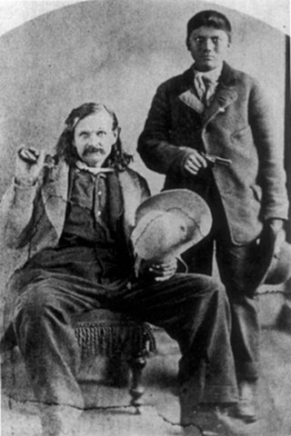
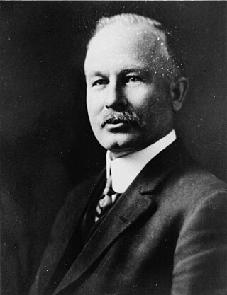
John W. "Jack" Swilling was an early pioneer in the Arizona Territory. He is commonly credited as one of the original founders of the city of Phoenix, Arizona. Swilling also played an important role in the opening of the central Arizona highlands to white settlement. His discoveries resulted in a gold rush to the region, and this in turn led to the establishment of Arizona's first territorial capital at the mining town of Prescott.
The Salt River Project (SRP) encompasses two separate entities: the Salt River Project Agricultural Improvement and Power District, an agency of the state of Arizona that serves as an electrical utility for the Phoenix metropolitan area, and the Salt River Valley Water Users' Association, a utility cooperative that serves as the primary water provider for much of central Arizona. It is one of the primary public utility companies in Arizona.
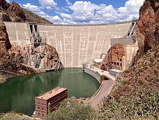
Theodore Roosevelt Dam is a dam on the Salt River located northeast of Phoenix, Arizona. The dam is 357 feet (109 m) high and forms Theodore Roosevelt Lake as it impounds the Salt River. Originally built between 1905 and 1911, the dam was renovated and expanded in 1989–1996. The dam is named after President Theodore Roosevelt. Serving mainly for irrigation, water supply, and flood control, the dam also has a hydroelectric generating capacity of 36 megawatts.
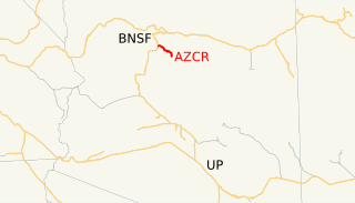
The Clarkdale Arizona Central Railroad is an Arizona short-line railroad that operates from a connection with the BNSF Railway at Drake, Arizona. The AZCR runs 37.8 miles (60.8 km) from Drake to Clarkdale, Arizona. An excursion train also runs on the line through Verde Canyon and is operated by the same owners under the Verde Canyon Railroad. The AZCR is owned by David L. Durbano.

The Salt River Pima–Maricopa Indian Community (SRPMIC) comprises two distinct Native American tribes—the Pima and the Maricopa —many of whom were originally part of the Halchidhoma (Xalchidom) tribe. The community was permanently created by an Executive Order of US President Rutherford Birchard Hayes on June 14th, 1879. The community area includes 53,600 acres (217 km2), of which 19,000 remain a natural preserve. As of 2022, the total population is 7,386. The community is a federally recognized tribe located in Arizona.

Arizona Falls is a waterfall in Phoenix, Arizona, U.S. It was formed when the man-made Arizona Canal crossed a natural, 20-foot (6.1 m) drop in the area of present-day 56th Street in the Arcadia neighborhood of Phoenix. The site became a popular location for social activities before and after being used as a hydroelectric power station that provided the first electricity to Phoenix. After generating power for 50 years, the site was left run down. Modern air conditioning lessened the attraction of the falls and the area was neglected for decades. In the early 2000s, the site was rebuilt both as a public-art project and a functional power station which generates enough electricity to power about 150 average Phoenix homes. Walkers, joggers, and cyclists using a recreation path along the canal pass through the park. It is also a destination attraction for other visitors. The modern park opened in 2003.

A trolleytruck is a trolleybus-like vehicle used for carrying cargo instead of passengers. A trolleytruck is usually a type of electric truck powered by two overhead wires, from which it draws electricity using two trolley poles. Two current collectors are required in order to supply and return current, because the return current cannot pass to the ground since trolleytrucks use tires that are insulators. Lower powered trucks, such as might be seen on the streets of a city, tend to use trolley poles for current collection. Higher powered trucks, such as those used for large construction or mining projects, may exceed the power capacity of trolley poles and have to use pantographs instead. Trolleytrucks have been used in various places around the world and are still in use in cities in Russia and Ukraine, as well as at mines in North America and Africa. Because they draw power from the mains, trolleytrucks can use renewable energy sources – modern trolleytrucks systems are under test in Sweden and Germany along highways using diesel–electric hybrids to reduce emissions.

Drake was an unincorporated community on the Verde River in Yavapai County, Arizona, United States, and a station on the BNSF Railway's Phoenix Subdivision. Drake is also the junction and western terminus of the Verde Canyon Railroad. Drake is the site of the old Hell Canyon Bridge, formerly used by US Route 89, and now on the National Register of Historic Places.

The history of Phoenix, Arizona, goes back millennia, beginning with nomadic paleo-Indians who existed in the Americas in general, and the Salt River Valley in particular, about 7,000 BC until about 6,000 BC. Mammoths were the primary prey of hunters. As that prey moved eastward, they followed, vacating the area. Other nomadic tribes moved into the area, mostly from Mexico to the south and California to the west. Around approximately 1,000 BC, the nomadic began to be accompanied by two other types of cultures, commonly called the farmers and the villagers, prompted by the introduction of maize into their culture. Out of these archaic Indians, the Hohokam civilization arose. The Hohokam first settled the area around 1 AD, and in about 500 years, they had begun to establish the canal system which enabled agriculture to flourish in the area. They suddenly disappeared by 1450, for unknown reasons. By the time the first Europeans arrived at the beginning of the 16th century, the two main groups of native Indians who inhabited the area were the O'odham and Sobaipuri tribes.
The following is a timeline of the history of the city of Phoenix, Arizona, United States.
