
An aquifer is an underground layer of water-bearing, permeable rock, rock fractures, or unconsolidated materials. Groundwater from aquifers can be extracted using a water well. Water from aquifers can be sustainably harvested through the use of qanats. Aquifers vary greatly in their characteristics. The study of water flow in aquifers and the characterization of aquifers is called hydrogeology. Related terms include aquitard, which is a bed of low permeability along an aquifer, and aquiclude, which is a solid, impermeable area underlying or overlying an aquifer, the pressure of which could create a confined aquifer. The classification of aquifers is as follows: Saturated versus unsaturated; aquifers versus aquitards; confined versus unconfined; isotropic versus anisotropic; porous, karst, or fractured; transboundary aquifer.

Wetlands, or simply a wetland, is a distinct ecosystem that is flooded or saturated by water, either permanently or seasonally. Flooding results in oxygen-free (anoxic) processes prevailing, especially in the soils. The primary factor that distinguishes wetlands from terrestrial land forms or water bodies is the characteristic vegetation of aquatic plants, adapted to the unique anoxic hydric soils. Wetlands are considered among the most biologically diverse of all ecosystems, serving as home to a wide range of plant and animal species. Methods for assessing wetland functions, wetland ecological health, and general wetland condition have been developed for many regions of the world. These methods have contributed to wetland conservation partly by raising public awareness of the functions some wetlands provide. Constructed wetlands are designed and built to treat municipal and industrial wastewater as well as to divert stormwater runoff. Constructed wetlands may also play a role in water-sensitive urban design.

The water table is the upper surface of the zone of saturation. The zone of saturation is where the pores and fractures of the ground are saturated with water. It can also be simply explained as the depth below which the ground is saturated.

Groundwater is the water present beneath Earth's surface in rock and soil pore spaces and in the fractures of rock formations. About 30 percent of all readily available freshwater in the world is groundwater. A unit of rock or an unconsolidated deposit is called an aquifer when it can yield a usable quantity of water. The depth at which soil pore spaces or fractures and voids in rock become completely saturated with water is called the water table. Groundwater is recharged from the surface; it may discharge from the surface naturally at springs and seeps, and can form oases or wetlands. Groundwater is also often withdrawn for agricultural, municipal, and industrial use by constructing and operating extraction wells. The study of the distribution and movement of groundwater is hydrogeology, also called groundwater hydrology.

The vadose zone, also termed the unsaturated zone, is the part of Earth between the land surface and the top of the phreatic zone, the position at which the groundwater is at atmospheric pressure. Hence, the vadose zone extends from the top of the ground surface to the water table.

Tablas de Daimiel National Park is a wetland on the La Mancha plain, a mainly arid area in the province of Ciudad Real. With an area of about 3,000 hectares, the park is the smallest of Spain's fifteen national parks. The protected area is in the process of being expanded outside the original nature reserve to include neighbouring dryland farming areas. The expansion is part of efforts to improve the condition of the wetland, which has been damaged by over-exploitation of water resources.
The capillary fringe is the subsurface layer in which groundwater seeps up from a water table by capillary action to fill pores. Pores at the base of the capillary fringe are filled with water due to tension saturation. This saturated portion of the capillary fringe is less than the total capillary rise because of the presence of a mix in pore size. If the pore size is small and relatively uniform, it is possible that soils can be completely saturated with water for several feet above the water table. Alternately, when the pore size is large, the saturated portion will extend only a few inches above the water table. Capillary action supports a vadose zone above the saturated base, within which water content decreases with distance above the water table. In soils with a wide range in pore size, the unsaturated zone can be several times thicker than the saturated zone.

A hydrosere is a plant succession which occurs in an area of fresh water such as in oxbow lakes and kettle lakes. In time, an area of open freshwater will naturally dry out, ultimately becoming woodland. During this change, a range of different landtypes such as swamp and marsh will succeed each other.

A ciénega is a wetland system unique to the American Southwest. Ciénagas are alkaline, freshwater, spongy, wet meadows with shallow-gradient, permanently saturated soils in otherwise arid landscapes that often occupy nearly the entire widths of valley bottoms. That description satisfies historic, pre-damaged ciénagas, although few can be described that way now. Incised ciénagas are common today. Ciénagas are usually associated with seeps or springs, found in canyon headwaters or along margins of streams. Ciénagas often occur because the geomorphology forces water to the surface, over large areas, not merely through a single pool or channel. In a healthy ciénaga, water slowly migrates through long, wide-scale mats of thick, sponge-like wetland sod. Ciénaga soils are squishy, permanently saturated, highly organic, black in color or anaerobic. Highly adapted sedges, rushes and reeds are the dominant plants, with succession plants—Goodding's willow, Fremont cottonwoods and scattered Arizona walnuts—found on drier margins, down-valley in healthy ciénagas where water goes underground or along the banks of incised ciénagas.

Groundwater recharge or deep drainage or deep percolation is a hydrologic process, where water moves downward from surface water to groundwater. Recharge is the primary method through which water enters an aquifer. This process usually occurs in the vadose zone below plant roots and is often expressed as a flux to the water table surface. Groundwater recharge also encompasses water moving away from the water table farther into the saturated zone. Recharge occurs both naturally and through anthropogenic processes, where rainwater and or reclaimed water is routed to the subsurface.

A sabkha is a coastal, supratidal mudflat or sandflat in which evaporite-saline minerals accumulate as the result of semiarid to arid climate. Sabkhas are gradational between land and intertidal zone within restricted coastal plains just above normal high-tide level. Within a sabkha, evaporite-saline minerals sediments typically accumulate below the surface of mudflats or sandflats. Evaporite-saline minerals, tidal-flood, and aeolian deposits characterize many sabkhas found along modern coastlines. The accepted type locality for a sabkha is at the southern coast of the Persian Gulf, in the United Arab Emirates. Evidence of clastic sabkhas are found in the geological record of many areas, incuding the UK and Ireland. Sabkha is a phonetic transliteration of the Arabic word used to describe any form of salt flat. A sabkha is also known as a sabkhah,sebkha, or coastal sabkha.
Dryland salinity is a natural process for soil, just like other processes such as wind erosion. Salinity degrades land by an increase in soil salt concentration in the environment, watercourse or soil in unirrigated landscapes, being in excess of normal soil salt concentrations in dryland regions.

Soil salinity control refers to controlling the process and progress of soil salinity to prevent soil degradation by salination and reclamation of already salty (saline) soils. Soil reclamation is also called soil improvement, rehabilitation, remediation, recuperation, or amelioration.
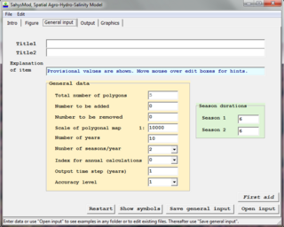
SahysMod is a computer program for the prediction of the salinity of soil moisture, groundwater and drainage water, the depth of the watertable, and the drain discharge in irrigated agricultural lands, using different hydrogeologic and aquifer conditions, varying water management options, including the use of ground water for irrigation, and several crop rotation schedules, whereby the spatial variations are accounted for through a network of polygons.
The phreatic zone, saturated zone, or zone of saturation, is the part of an aquifer, below the water table, in which relatively all pores and fractures are saturated with water. Above the water table is the unsaturated or vadose zone.
Groundwater remediation is the process that is used to treat polluted groundwater by removing the pollutants or converting them into harmless products. Groundwater is water present below the ground surface that saturates the pore space in the subsurface. Globally, between 25 per cent and 40 per cent of the world's drinking water is drawn from boreholes and dug wells. Groundwater is also used by farmers to irrigate crops and by industries to produce everyday goods. Most groundwater is clean, but groundwater can become polluted, or contaminated as a result of human activities or as a result of natural conditions.

Freshwater biology is the scientific biological study of freshwater ecosystems and is a branch of limnology. This field seeks to understand the relationships between living organisms in their physical environment. These physical environments may include rivers, lakes, streams, ponds, lakes, reservoirs, or wetlands. Knowledge from this discipline is also widely used in industrial processes to make use of biological processes involved with sewage treatment and water purification. Water presence and flow is an essential aspect to species distribution and influences when and where species interact in freshwater environments.
Groundwater-Dependent Ecosystems are ecosystems that rely upon groundwater for their continued existence. Groundwater is water that has seeped down beneath Earth's surface and has come to reside within the pore spaces in soil and fractures in rock, this process can create water tables and aquifers, which are large storehouses for groundwater. An ecosystem is a community of living organisms interacting with the nonliving aspects of their environment. With a few exceptions, the interaction between various ecosystems and their respective groundwater is a vital yet poorly understood relationship, and their management is not nearly as advanced as in-stream ecosystems.
A cypress dome is a type of freshwater forested wetland, or a swamp, found in the southeastern part of the United States. They are dominated by the Taxodium spp., either the bald cypress, or pond cypress. The name comes from the dome-like shape of treetops, formed by smaller trees growing on the edge where the water is shallow while taller trees grow at the center in deeper water. They usually appear as circular, but if the center is too deep, they form a “doughnut” shape when viewed from above. Cypress domes are characteristically small compared to other swamps, however they can occur at a range of sizes, dependent on the depth.
In a cave system, the epiphreatic zone or floodwater zone is the zone between the vadose (unsaturated) zone above and phreatic (saturated) zone below. It is regularly flooded and has a significant porosity. It has a great potential for cave formation.