
Rio de Janeiro, or simply Rio, is a very large city in the Southeast Region of Brazil. Listed by the GaWC as a beta global city, the municipality of Rio de Janeiro is the second-most populous city in Brazil and the sixth-most populous in the Americas. Rio de Janeiro serves as the capital of the state of the same name, Brazil's third-most populous state. Part of the city has been designated as a World Heritage Site, named "Rio de Janeiro: Carioca Landscapes between the Mountain and the Sea", on 1 July 2012 as a Cultural Landscape.

The Tijuca National Park is an urban national park in the mountains of the city of Rio de Janeiro, Brazil. The park is part of the Atlantic Forest Biosphere Preserve, and is administered by the Chico Mendes Institute for Biodiversity Conservation (ICMBio).

Manhuaçu is a municipality in Eastern Minas Gerais state, in Brazil. Its population was 91,169 (2020) and its area is 628 km2.

Itatiaia National Park, established in 1937, is the oldest national park in Brazil. It is located on the border between the states of Rio de Janeiro and Minas Gerais.

Pico das Agulhas Negras is the fifth-highest mountain in Brazil, standing at 2,791 metres (9,157 ft) above sea level, making it one of the highest in the Brazilian Highlands. It is located in Itatiaia National Park, in the Serra da Mantiqueira range, on the border of the states of Rio de Janeiro and Minas Gerais. It is the highest point in the state of Rio de Janeiro, the third-highest peak in Minas Gerais, and the second-highest in the Mantiqueira range.

Teresópolis is a Brazilian municipality located in the state of Rio de Janeiro, in a mountainous region known as Região Serrana. The Serra dos Órgãos National Park lies partly within the city limits. The city is known as the home of the Brazil national football team, since it hosts CBF's training ground at Granja Comary.

Pico da Neblina is the highest peak in Brazil, 2,995.3 metres (9,827 ft) above sea level, in the Serra da Neblina, part of the Serra do Imeri, a section of the Guiana Highlands on the Brazil-Venezuela border. As determined by a border survey expedition in 1962, its summit lies just within Brazilian territory, at a horizontal distance of only 687 m (2,254 ft) from the Venezuelan border at Pico 31 de Março.

Tijuca is a neighbourhood of the Northern Zone of the city of Rio de Janeiro, Brazil. It comprises the region of Saens Peña and Afonso Pena squares. According to the 2000 Census, the district has close to 150,000 inhabitants. It borders with Praça da Bandeira, Maracanã, Vila Isabel, Andaraí, Grajaú and Alto da Boa Vista neighbourhoods.

Barra da Tijuca is an upper-class neighborhood or bairro in the West Zone of Rio de Janeiro, Brazil, located in the western portion of the city on the Atlantic Ocean. Barra is well known for its beaches, its many lakes and rivers, and its lifestyle. This neighbourhood represents 4.7% of the city population and 13% of the total area of Rio de Janeiro.

The Mantiqueira Mountains are a mountain range in Southeastern Brazil, with parts in the states of São Paulo, Minas Gerais and Rio de Janeiro. It rises abruptly from the northwestern bank of the Paraíba do Sul River and extends northeastward for approximately 320 km (200 mi), reaching a height of 2,798 m (9,180 ft) at Pedra da Mina. The mountains, which eventually merge with the Serra do Espinhaço, were originally forest-covered, except for the peaks that rise above the tree line. They provide charcoal and pasture for cattle; on the lower slopes there are several health and tourist resorts, such as Campos do Jordão, Brazil's highest city. The name Mantiqueira derives from a Tupi word meaning "mountains that cry", denoting the large number of springs and streams found there.

Pedra da Gávea is a monolithic mountain in Tijuca Forest, Rio de Janeiro, Brazil. Composed of granite and gneiss, its elevation is 844 metres (2,769 ft), making it one of the highest mountains in the world that ends directly in the ocean. Trails on the mountain were opened up by the local farming population in the early 1800s; today, the site is under the administration of the Tijuca National Park.

Guapimirim, is a Brazilian Municipality in the state of Rio de Janeiro around 50km(31 miles) from its state capital, the city of Rio de Janeiro. Its in a region known as Baixada Fluminense and the Greater Rio de Janeiro metropolitan area.
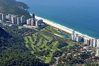
São Conrado is a neighborhood in the South Zone of the city of Rio de Janeiro, Brazil. It is nestled in between the neighborhoods of Barra da Tijuca to the southwest and Leblon to the northeast. The neighborhood takes its name from a small church, Igreja de São Conrado, which was constructed early in the 20th century by Conrado Jacob Niemeyer (1831-1905). São Conrado, which ranks as one of the areas with the highest Human Development Index in Brazil, presents a stark contrast to Rocinha on its border, which is one of the largest and poorest favelas in Brazil.
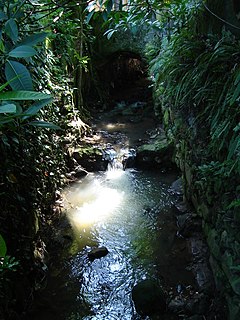
The Carioca River is a river in the state of Rio de Janeiro state in southeastern Brazil. It emerges from two springs on the southeast slopes of the Tijuca Massif in the protected Mata Atlantica forest of Tijuca National Park. The river then leaves Tijuca Forest into the Guararapes favela, then into the high-income Cosme Velho neighborhood, and then it is buried completely underground. The river reemerges in Flamengo Park to empty into Guanabara Bay at Flamengo Beach.
Aldeia Campista was a neighborhood in Rio de Janeiro, Brazil, close to contemporary Vila Isabel, Tijuca, Maracanã and Andaraí.

Pico dos Marins is a mountain peak in Brazil, between the cities of Piquete and Cruzeiro, state of São Paulo. The peak stands only about 1 kilometre (0.62 mi) south of the Minas Gerais state border, but it is located entirely in São Paulo territory. It is part of a short spur of the southwestern section of the Mantiqueira Mountains, and it has an elevation of 2,420.7 metres (7,942 ft).

The Três Picos State Park is a state park in the state of Rio de Janeiro, Brazil. It preserves a large, mountainous region of Atlantic Forest.
The Pedra Branca State Park is a state park in the state of Rio de Janeiro, Brazil. It is one of the largest urban nature parks in the world. It protects an area of Atlantic Forest in the west of the city of Rio de Janeiro that includes the highest point in the city, the Pico da Pedra Branca.

Rio de Janeiro is on the far western part of a strip of Brazil's Atlantic coast, close to the Tropic of Capricorn, where the shoreline is oriented east–west. Facing largely south, the city was founded on an inlet of this stretch of the coast, Guanabara Bay, and its entrance is marked by a point of land called Sugar Loaf – a "calling card" of the city.
The following outline is provided as an overview of and topical guide to Rio de Janeiro:

