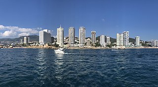
Acapulco de Juárez, commonly called Acapulco, is a city and major seaport in the state of Guerrero on the Pacific Coast of Mexico, 380 kilometres (240 mi) south of Mexico City. Acapulco is located on a deep, semicircular bay and has been a port since the early colonial period of Mexico's history. It is a port of call for shipping and cruise lines running between Panama and San Francisco, California, United States. The city of Acapulco is the largest in the state, far larger than the state capital Chilpancingo. Acapulco is also Mexico's largest beach and balneario resort city. Acapulco de Juárez is the municipal seat of the municipality of Acapulco.

Guerrero, officially the Free and Sovereign State of Guerrero, is one of the 32 states that comprise the 32 Federal Entities of Mexico in Mexico. It is divided in 81 municipalities. The state has a population of about 3.5 million people. It is located in southwest Mexico and is bordered by the states of Michoacán to the north and west, the State of Mexico and Morelos to the north, Puebla to the northeast and Oaxaca to the east. In addition to the capital city, Chilpancingo and the largest city Acapulco, other cities in Guerrero include Petatlán, Ciudad Altamirano, Taxco, Iguala, Ixtapa, and Zihuatanejo. Today, it is home to a number of indigenous communities, including the Nahuas, Mixtecs, Tlapanecs, Amuzgos, and formerly Cuitlatecs. It is also home to communities of Afro-Mexicans in the Costa Chica region.

Puerto Vallarta is a Mexican beach resort city on the Pacific Ocean's Bahía de Banderas in the Mexican state of Jalisco. Puerto Vallarta is the second largest urban agglomeration in the state after the Guadalajara Metropolitan Area. The City of Puerto Vallarta is the government seat of the Municipality of Puerto Vallarta, which comprises the city as well as population centers outside of the city extending from Boca de Tomatlán to the Nayarit border. The city is located at 20°40′N105°16′W. The municipality has an area of 681 square kilometres (262.9 sq mi). To the north, it borders the southwest of the state of Nayarit. To the east, it borders the municipality of Mascota and San Sebastián del Oeste, and to the south, it borders the municipalities of Talpa de Allende and Cabo Corrientes.

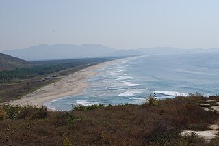
Puerto Escondido is a small port and tourist center in the municipality of San Pedro Mixtepec Distrito 22 in the Mexican state of Oaxaca. Prior to the 1930s, there was no town. The bay had been used as a port intermittently to ship coffee, but there was no permanent settlement due to the lack of potable water. The name "Puerto Escondido" had roots in the legend of a woman who escaped her captors and hid here. The Nahuatl word for this area was Zicatela, meaning “place of large thorns". Today, it refers to the area's most famous beach.

Tourism in Mexico is a very important industry. Since the 1960s, it has been heavily promoted by the Mexican government, as "an industry without smokestacks." Mexico has traditionally been among the most visited countries in the world according to the World Tourism Organization, and it is the second-most visited country in the Americas, after the United States. In 2017, Mexico was ranked as the sixth-most visited country in the world for tourism activities. Mexico has a significant number of UNESCO World Heritage Sites, with the list including ancient ruins, colonial cities, and natural reserves, as well as a number of works of modern public and private architecture. Mexico has attracted foreign visitors beginning in the early nineteenth century, with its cultural festivals, colonial cities, nature reserves and the beach resorts. The nation's temperate climate and unique culture – a fusion of the European and the Mesoamerican – are attractive to tourists. The peak tourism seasons in the country are during December and the mid-Summer, with brief surges during the week before Easter and Spring break, when many of the beach resort sites become popular destinations for college students from the United States.

Zihuatanejo, and/or Ixtapa-Zihuatanejo, is the fourth-largest city in the Mexican state of Guerrero. It was known by 18th-century English mariners as Chequetan and/or Seguataneo. Politically the city belongs to the municipality of Zihuatanejo de Azueta in the western part of Guerrero, but both are commonly referred to as Zihuatanejo. It is on the Pacific Coast, about 240 km northwest of Acapulco and 411 km further south in latitude than Honolulu, Hawaii. Zihuatanejo belongs to a section of the Mexican Pacific Coast known as the Costa Grande. This town has been developed as a tourist attraction along with the modern tourist resort of Ixtapa, 5 km (3.1 mi) away. However, Zihuatanejo has kept its traditional town feel. The town is located on a well-protected bay which is popular with private boat owners during the winter months.
Huatulco, formally Bahías de Huatulco, centered on the town of La Crucecita, is a tourist development in Mexico. It is located on the Pacific coast in the state of Oaxaca. Huatulco's tourism industry is centered on its nine bays, thus the name Bahias de Huatulco, but has since been unofficially shortened to simply Huatulco. Huatulco has a wide variety of accommodation from rooms for rent, small economy hotels, luxury villas, vacation condominia, bed and breakfasts, as well as several luxury resorts standing on or near the shores of Tangolunda Bay. The Camino Real Zaashila, Quinta Real Huatulco, Las Brisas, Dreams Resort & Spa, and the Barceló are examples of the most popular larger resorts in the area.

Ixtapa is a resort city in Mexico, adjacent to the Pacific Ocean in the municipality of Zihuatanejo de Azueta in the state of Guerrero. It is located 5 km (3 mi) northwest of the municipal seat, Zihuatanejo, and 245 km (150 mi) northwest of Acapulco.
Cuajinicuilapa is a town in Cuajinicuilapa Municipality in the Costa Chica region of the Mexican state of Guerrero. A low-lying area, it borders the Pacific Ocean and the state of Oaxaca. The municipality has the state's largest population of Afro-Mexicans with most of the population of this ethnicity. The town and municipality are highly socioeconomically marginalized and it is the poorest municipality of the state, with the economy dependent on livestock and fishing.
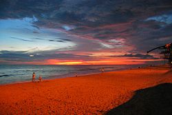
Luces en el Mar is a small town in the Mexican state of Guerrero, approximately 5.5 miles north-west of Acapulco. It is the location of a military base of the Mexican Air Force situated on a long stretch of land bordered by rough seas on one side and a very calm lagoon on the other. Waterskiing can be done in the lagoon, as can trips to see the island, Isla Montosa. On the lagoon side, one can find crocodiles in which the gentleman that once lived there caught. The beach's somewhat rougher waves and remote location away from the tourist center of Acapulco account for its lack of popularity among tourists. But, the "closer-to-nature" atmosphere and romantic sunsets are a reward for those that venture there.

The Costa Chica of Guerrero is an area along the south coast of the state of Guerrero, Mexico, extending from just south of Acapulco to the Oaxaca border. Geographically, it consists of part of the Sierra Madre del Sur, a strip of rolling hills that lowers to coastal plains to the Pacific Ocean. Various rivers here form large estuaries and lagoons that host various species of commercial fish.
Costa Grande of Guerrero is a sociopolitical region located in the Mexican state of Guerrero, along the Pacific Coast. It makes up 325 km (202 mi) of Guerrero's approximately 500 km (311 mi) coastline, extending from the Michoacán border to the Acapulco area, wedged between the Sierra Madre del Sur and the Pacific Ocean. Acapulco is often considered part of the Costa Grande; however, the government of the state classifies the area around the city as a separate region. The Costa Grande roughly correlates to the Cihuatlán province of the Aztec Empire, which was conquered between 1497 and 1504. Before then, much of the area belonged to a dominion under the control of the Cuitlatecs, but efforts by both the Purépecha Empire and Aztec Empire to expand into this area in the 15th century brought this to an end. Before the colonial period, the area had always been sparsely populated with widely dispersed settlements. The arrival of the Aztecs caused many to flee and the later arrival of the Spanish had the same effect. For this reason, there are few archeological remains; however, recent work especially at La Soledad de Maciel has indicated that the cultures here are more important than previously thought. Today, the area economically is heavily dependent on agriculture, livestock, fishing and forestry, with only Zihuatanejo and Ixtapa with significantly developed infrastructure for tourism. The rest of the coast has been developed spottily, despite some government efforts to promote the area.

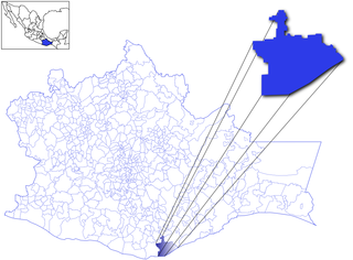
Acapulco de Juárez is one of the 81 municipalities of Guerrero, in southwestern Mexico, along Acapulco Bay on the Pacific coast. The municipal seat lies at Acapulco.
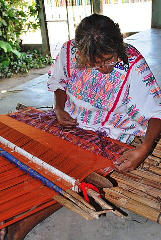
The handcrafts of Guerrero include a number of products which are mostly made by the indigenous communities of the Mexican state of Guerrero. Some, like pottery and basketry, have existed relatively intact since the pre Hispanic period, while others have gone through significant changes in technique and design since the colonial period. Today, much of the production is for sale in the state's major tourism centers, Acapulco, Zihuatanejo and Taxco, which has influence the crafts’ modern evolution. The most important craft traditions include amate bark painting, the lacquerware of Olinalá and nearby communities and the silverwork of Taxdo.
The Independent Cartel of Guerrero was a criminal gang based in the Mexican resort city of Acapulco, Guerrero and its surrounding territories. The criminal group came into existence during the rapid decentralization of Mexico's drug trafficking organizations as a split-off group of the Beltrán-Leyva Cartel. Originally, the Beltrán Leyva cartel operated in the city, but the group no longer has presence in Acapulco. After the Mexican military gunned down the top boss of the cartel – Arturo Beltrán Leyva – in December 2009, his brother Héctor Beltrán Leyva took control of one of the factions of the cartel and declared war on Edgar Valdez Villarreal, who had long been the right hand of Arturo. Amidst the violence, Valdez Villarreal tried to appoint a successor, but those in Acapulco broke off and formed their own criminal gang: the Independent Cartel of Acapulco. Within weeks, however, the group had splintered also, forming a new and rival group known as La Barredora. Villarreal Valdez was then captured by the Mexican Federal Police in August 2010, but the violence between the groups for the control of Acapulco continued.

The Triangle of the Sun is a tourist area in the state of Guerrero that runs through the Sierra Madre del Sur of that state. This tourist area is formed by the cities of Acapulco in the south, the pair of Ixtapa-Zihuatanejo in the north, and Taxco in the center of the state. These cities are those that receive more tourists in Guerrero.
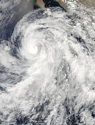
Hurricane Cosme caused flooding along the Pacific coast of Mexico in June 2013. The third named tropical cyclone of the 2013 Pacific hurricane season, the storm system formed from a tropical wave south of Manzanillo, Colima, on June 23. The cyclone intensified into a tropical storm on June 24, and soon after strengthened into a hurricane on June 25. Early the following day, Cosme attained its peak intensity as a Category 1 hurricane on the Saffir–Simpson scale with maximum sustained winds of 85 mph (140 km/h) and a minimum barometric pressure of 980 mbar. However, Cosme then began to encounter stable air and lower sea surface temperatures, causing the system to weaken to a tropical storm late on June 26. The system continued to weaken and degenerated into a remnant low pressure surface trough about 690 mi (1,110 km) west-southwest of Cabo San Lucas, Mexico, on June 27. The remnants persisted until dissipating well east-southeast of the Hawaiian Islands on July 1.
The following is a timeline of the history of the city of Acapulco de Juárez, Guerrero, Mexico.

Hurricane Bud was a Category 4 hurricane that brought winds and severe flooding to Mexico throughout its existence as a tropical cyclone in June 2018. It was the second named storm, hurricane, and major hurricane of the 2018 Pacific hurricane season. Bud originated from a tropical wave that departed from Western Africa on May 29. It traveled across the Atlantic Ocean before entering the Northeast Pacific Ocean late on June 6. The system moved towards the northwest and steadily organized, becoming a tropical depression on June 9 and Tropical Storm Bud early the next day. Favorable upper-level winds, ample moisture aloft, and warm sea surface temperatures allowed the storm to rapidly intensify to a hurricane late on June 10, and further to a major hurricane on the following day. Bud ultimately peaked the next morning with maximum sustained winds of 140 mph (230 km/h) and a minimum central pressure of 943 mbar. Its track curved more northward while the storm rapidly succumbed to the effects of upwelling. Bud made landfall on Baja California Sur as a minimal tropical storm early on June 15. On the next day, land interaction and increasing wind shear caused Bud to degenerate into a post-tropical cyclone. It opened up into a trough of low-pressure on June 16. The remnants of Bud moved towards the Southwestern United States, bringing tropical moisture and gusty winds to the region.

Pie de la Cuesta Air Force Base is a military airport located in Pie de la Cuesta in the Mexican state of Guerrero.