
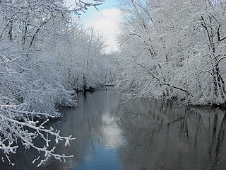
The Au Sable River in Michigan, United States runs approximately 138 miles (222 km) through the northern Lower Peninsula, through the towns of Grayling and Mio, and enters Lake Huron at the town of Oscoda. It is considered one of the best brown trout fisheries east of the Rockies and has been designated a blue ribbon trout stream by the Michigan Department of Natural Resources. A map from 1795 located in the United States Gazetteer calls it the Beauais River. In French, the river is called the Rivière au sable, literally "Sand River".

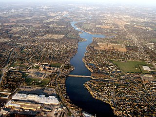
Muskegon River is a river in the western portion of the lower peninsula of the U.S. state of Michigan. The river source is located at Houghton Lake in Roscommon County, flowing out of the North Bay into neighboring Missaukee County. The river passes through Clare County, Osceola County, Mecosta County, Newaygo County, and Muskegon County, and generally flows southwesterly to its mouth at Muskegon, Michigan, where it empties into Muskegon Lake. Muskegon Lake is connected to Lake Michigan via a mile-long channel. The river has several major branches, such as the Hersey River, Cedar Creek and Little Muskegon River. The primary river channel is 216 miles (348 km) long and drains an area of 2,350 square miles (6,100 km2). In September 2002, an article in National Geographic raised concerns about a controversial deal made with Nestlé Waters North America, giving them permission "to bottle up to 210 million gallons a year from an aquifer north of Grand Rapids, Michigan that recharges the Muskegon River".

The Kalamazoo River is a river in the U.S. state of Michigan. The river is 130 miles (210 km) long from the junction of its North and South branches to its mouth at Lake Michigan, with a total length extending to 178 miles (286 km) when one includes the South Branch. The river's watershed drains an area of approximately 2,020 square miles (5,200 km2) and drains portions of ten counties in southwest Michigan: Allegan, Barry, Eaton, Van Buren, Kalamazoo, Calhoun, Jackson, Hillsdale, Kent and Ottawa. The river has a median flow of 1,863 cubic feet per second (52.8 m3/s) at New Richmond, upstream from its mouth at Saugatuck and Douglas.

The Snowy River is a major river in south-eastern Australia. It originates on the slopes of Mount Kosciuszko, Australia's highest mainland peak, draining the eastern slopes of the Snowy Mountains in New South Wales, before flowing through the Alpine National Park and the Snowy River National Park in Victoria and emptying into Bass Strait.

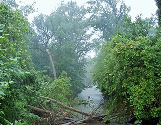
The Huron River is a 130-mile-long (210 km) river in southeastern Michigan, rising out of the Huron Swamp in Springfield Township in northern Oakland County and flowing into Lake Erie, as it forms the boundary between present-day Wayne and Monroe counties. Thirteen parks, game areas, and recreation areas are associated with the river, which passes through the cities of Dexter, Ann Arbor, Ypsilanti, Belleville, Flat Rock and Rockwood that were developed along its banks.
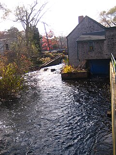
The Paw Paw River is located in the U.S. state of Michigan in the southwest portion of the lower peninsula. It is formed by the confluence of the north and south branches at 42°15′17″N85°55′36″W in Waverly Township in the northeast of Van Buren County. It flows approximately 61.8 miles (99.5 km) through Van Buren County and Berrien County until joining the St. Joseph River just above its mouth on Lake Michigan at Benton Harbor.
The St. Joseph River is a tributary of Lake Michigan with a length of 206 miles (332 km). The river flows in a generally westerly direction through southern Michigan and northern Indiana, United States, to its terminus on the southeast shore of the lake. It drains a primarily rural farming area in the watershed of Lake Michigan. It was enormously important to Native Americans and greatly aided in the colonial exploration, settlement and administration of New France and the nascent United States as a canoe route between Lake Michigan and the watershed of the Mississippi River.
The Jones River is a 7.5-mile-long (12.1 km) river running through Kingston, Massachusetts. The river drains about 30 square miles (78 km2), has its source in Silver Lake and drains into Kingston Bay. Land surrounding the river is 52% forested, of which 22% has been developed for residential use. There is a USGS stream gauge along 16 square miles (41 km2) of the river and it has measured the flow at 0.7 cubic feet per second (0.020 m3/s) per square mile of drainage area.

The Manistee River, seldom referred to as the Big Manistee River, runs 190 miles (310 km) through the northwestern Lower Peninsula of Michigan; it now passes through the contemporary villages of Sharon, Smithville, and Mesick, entering Lake Michigan at Manistee. It is considered, like the nearby Au Sable River, to be one of the best trout fisheries east of the Rockies. The Manistee River is also being considered for restoration of Arctic grayling, which have been extirpated from the State of Michigan since 1936.

The Elwha Dam was a 108-ft high dam located in the United States, in the state of Washington, on the Elwha River approximately 4.9 miles (7.9 km) upstream from the mouth of the river on the Strait of Juan de Fuca.

Browning Pond is located in Oakham and Spencer, Massachusetts. This 89-acre (360,000 m2) great pond forms the headwaters of the Seven Mile River. It is part of the Chicopee River Watershed.

Dam removal is the process of demolishing a dam, returning water flow to the river. Arguments for dam removal consider whether their negative effects outweigh their benefits. The benefits of dams include hydropower production, flood control, irrigation, and navigation. Negative effects of dams include environmental degradation, such as reduced primary productivity, loss of biodiversity, and declines in native species; some negative effects worsen as dams age, like structural weakness, reduced safety, sediment accumulation, and high maintenance expense. The rate of dam removals in the United States has increased over time, in part driven by dam age. As of 1996, 5,000 large dams around the world were more than 50 years old. In 2020, 85% percent of dams in the United States are more than 50 years old. In the United States roughly 900 dams were removed between 1990 and 2015, and by 2015, the rate was 50 to 60 per year. France and Canada have also completed significant removal projects. Japan's first removal, of the Arase Dam on the Kuma River, began in 2012 and was completed in 2017. A number of major dam removal projects have been motivated by environmental goals, particularly restoration of river habitat, native fish, and unique geomorphological features. For example, fish restoration motivated the Elwha Ecosystem Restoration and the dam removal on the river Allier, while recovery of both native fish and of travertine deposition motivated the restoration of Fossil Creek.

Boyne River is a stream in Northern Michigan, named for the River Boyne in Leinster, Ireland. Together with the north and south branches, the river system has approximately 22 miles (35 km) of mainstream and the water basin drains 40,320 acres (163.2 km2). Boyne River is Lake Charlevoix's second-largest tributary, after the Jordan River.
The Roach River is a river in Piscataquis County, Maine. From the outlet of Third Roach Pond in Shawtown, the river runs 19.1 miles (30.7 km) west, through a chain of ponds. The Flow sequence through the ponds is from the Fourth Roach Pond through the Third Roach Pond, Second Roach Pond, and First Roach Pond to empty into Moosehead Lake, the source of the Kennebec River, in Spencer Bay. The Seventh Roach Pond drains through the Sixth Roach Pond in a separate tributary to the Third Roach Pond. No fifth Roach Pond is shown on modern maps.

Holter Dam is a hydroelectric straight gravity dam on the Missouri River about 45 miles (72 km) northeast of Helena, Montana, in the United States. The dam, which was built between 1908 and 1918, is 1,364 feet (416 m) long and 124 feet (38 m) high. The reservoir formed by the dam, Holter Lake is 25 miles (40 km) long and has a storage capacity of 243,000 acre-feet (300,000,000 m3) of water when full. The dam is a "run-of-the-river" dam because it can generate electricity without needing to store additional water supplies behind the dam.
The East Arm Little Calumet River, also known as the Little Calumet River East Branch, is a 22.1-mile-long (35.6 km) portion of the Little Calumet River that begins just east of Holmesville, Indiana in New Durham Township in LaPorte County and flows west to Porter County and the Port of Indiana-Burns Waterway.

Salt Creek is a 24.0-mile-long (38.6 km) tributary of the East Arm Little Calumet River that begins south of Valparaiso in Porter County, Indiana and flows north until it joins the East Arm Little Calumet River just before it exits to Lake Michigan via the Port of Indiana-Burns Waterway.
Upper Richardson Lake and Lower Richardson Lake are impounded as a single reservoir by Middle Dam at the outlet to Rapid River on the western shore of the lower lake. Rapid River flows 5 miles (8.0 km) to Umbagog Lake headwaters of the Androscoggin River. Upper Richardson Lake is in the western portion of Richardsontown township, and the lower lake is on the border of Magalloway Plantation and Maine Township C. Primary inflow is discharge over Upper Dam on Mooselookmeguntic Lake on the eastern shore of the upper lake. Smaller tributaries entering the north end of the upper lake include Mill Brook draining the Richardson Ponds, Fish Brook draining Fish Pond, and Beaver Brook draining Beaver Pond, Little Beaver Pond, and Aziscohos Pond. Other small tributaries include Rand Brook on the western shore, and Mosquito Brook, Metallak Brook, and Bailey Brook on the eastern shore. The lake offers excellent habitat for adult trout, but with dams on the outlet and major inlet, fish populations are limited by the insufficient spawning and nursery areas of these small tributaries. The public boat launch area at the north end of the upper lake is 1 mile (1.6 km) off Maine State Route 16; and the boat launch area at the south end of the lower lake is accessed by driving 12 miles (19 km) north of Andover on South Arm Road.

The Rio Grande Chub is a cyprinid fish endemic to the United States. It inhabits the upper Rio Grande and Pecos River systems in Colorado, New Mexico and Texas. The Rio Grande Chub is native to most of its current range including all three of the states it can be found in. There are non-native populations that currently inhabit Coyote Creek, the Mora River, the Sapello River and other areas in New Mexico. There are currently no studies showing how the Rio Grande Chub is impacting waterways in its non-native range. It has also been proposed that this fish is native to the Canadian River in New Mexico but this has not been proven. It is possible it was introduced there. Natural hybridization can occur between the Rio Grande Chub and the Longnose dace.