
The province of Potenza is a province in the Basilicata region of Italy. Its capital is the city of Potenza.

Tito is a town and comune in the province of Potenza, in the Southern Italian region of Basilicata. It is bounded by the comuni of Abriola, Picerno, Pignola, Potenza, Sant'Angelo Le Fratte, Sasso di Castalda, Satriano di Lucania, Savoia di Lucania.

Maschito is a town and comune of the province of Potenza, in the Basilicata region of southern Italy. Like other towns in the Vulture area, Maschito was repopulated by Albanian refugees after the occupation of Albania by the Ottoman Empire.

The Basento is a river in the Basilicata region of southern Italy. It rises at Monte Arioso in the southern Apennine Mountains, southwest of Potenza in the province of Potenza. The river flows northeast near Pignola and Potenza before curving east near Vaglio Basilicata. It curves southeast and flows near Brindisi Montagna, Trivigno, and Albano di Lucania. A right tributary coming from Lago di Ponte Fontanelle flows into the river in this area. The river forms the border between the province of Potenza and the province of Matera for a short distance before flowing into the province of Matera. It flows eastward near Tricarico, Calciano, and Grassano before curving southeast. The river flows near Grottole, Miglionico, Pomarico, Ferrandina, and Monte Finese before curving eastward. It flows near Pisticci and Bernalda before flowing into the Gulf of Taranto, which is part of the Ionian Sea, near Metaponto. The main city on the Basento is Potenza, the capital of Basilicata.

Marsicovetere is a town of and comune in the province of Potenza, in the Southern Italian region of Basilicata.

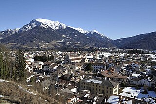
Anzi is a town and comune in the province of Potenza, in the Southern Italian region of Basilicata.

Potenza is a comune in the Southern Italian region of Basilicata.

Capannori is an Italian town and comune in the province of Lucca, in northern Tuscany.

Nemoli is a town and comune of 1,501 inhabitants, found in the province of Potenza, in the Southern Italian region of Basilicata. The town, positioned between the Apennine Mountains, is noted for its artisanal work, typically in wood and copper.

Noepoli is a comune in the province of Potenza, in the southern Italian region of Basilicata. This ancient Lucanian village is situated in the Sarmento Valley, at the heart of the Pollino National Park.

Castelcivita is a town and comune in the province of Salerno in the Campania region of south-western Italy.

Roure is a comune (municipality) in the Metropolitan City of Turin in the Italian region of Piedmont, located about 45 kilometres (28 mi) west of Turin in the Val Chisone.

Laghi is a town and a comune in the province of Vicenza, Veneto, north-eastern Italy. It is west of SP350 provincial road. Laghi is Veneto's municipality with the smallest number of inhabitants and also the one with the lowest density. The municipality consists of a number of small hamlets scattered over the territory of the town. The name Laghi literally means "lakes" and is related to the fact that two small lakes lie in the center of the town.

Centallo is a comune (municipality) in the Province of Cuneo in the Italian region Piedmont, located about 60 kilometres south of Turin and about 13 kilometres north of Cuneo.
Lambrugo is a comune (municipality) in the Province of Como in the Italian region Lombardy, located about 30 kilometres (19 mi) north of Milan and about 14 kilometres (9 mi) southeast of Como. As of 30 November 2019, it had a population of 2,510 and an area of 1.9 km2. The municipality of Lambrugo contains the frazioni Momberto, Galletto, Cascina Giulia, and Resegone. Lambrugo borders the following municipalities: Costa Masnaga, Inverigo, Lurago d'Erba, Merone, Nibionno.

Predore is a comune (municipality) in the Province of Bergamo in the Italian region of Lombardy, located about 70 kilometres (43 mi) northeast of Milan and about 25 kilometres (16 mi) east of Bergamo. As of 31 December 2004, it had a population of 1,837 and an area of 11.6 square kilometres (4.5 sq mi).

Cavriana is a comune (municipality) in the Province of Mantua in the Italian region Lombardy, part of the municipalities of Alto Mantovano.

Domegge di Cadore is a comune (municipality) in the Province of Belluno in the Italian region of Veneto, located about 120 kilometres (75 mi) north of Venice and about 40 kilometres (25 mi) northeast of Belluno.
Lamon is a comune (municipality) in the province of Belluno in the Italian region of Veneto, located about 80 kilometres (50 mi) northwest of Venice and about 35 kilometres (22 mi) west of Belluno. As of 31 December 2004, it had a population of 3,322 and an area of 54.3 square kilometres (21.0 sq mi).
San Ferdinando is a comune (municipality) in the Province of Reggio Calabria in the Italian region Calabria, located about 80 kilometres (50 mi) southwest of Catanzaro and about 45 kilometres (28 mi) northeast of Reggio Calabria. As of 31 December 2004, it had a population of 4,487 and an area of 14.0 square kilometres (5.4 sq mi).


