Pike Street

Last updated
Pike Street
Washington State Convention Center skybridge and lobby from 7th Avenue.jpg
The Washington State Convention Center straddles Pike Street at 7th Avenue
TypeArterial street
Maintained by Seattle Department of Transportation
Location Seattle
West end Pike Place in Downtown Seattle
Major
junctions
Interstate 5, Broadway, Madison Street
East end Lake Washington Boulevard in Madrona
Construction
Inauguration1869 (1869)

Pike Street is an east-west street in Seattle. It extends from Pike Place above Seattle's saltwater waterfront at Elliott Bay through Downtown Seattle, across Capitol Hill to the freshwater shore of Lake Washington at Lake Washington Boulevard. A segment less than a block long exists at Alaskan Way on Elliott Bay, connected to the rest of the street only by the pedestrian Pike Street Hill Climb; the bottom of the hillclimb under the Alaskan Way Viaduct was the original shoreline of the city before major modification and construction of the Seattle Seawall. [1] It is included in the south-to-north mnemonic "Jesus Christ Made Seattle Under Protest" for the street layout of Seattle. [2]

Contents

History and culture

Pike Street in 1891, unpaved Pike St from near 1st Ave, Seattle, Washington, ca 1891 (LAROCHE 28).jpeg
Pike Street in 1891, unpaved

The street was one of the original named streets of Seattle in Arthur A. Denny's 1869 platting. It was named by him for John Pike, architect and builder of the Washington Territorial University in what is now the Metropolitan Tract of downtown Seattle. [3] Until the early 20th century Denny Regrade leveled Denny Hill, it was the easiest way from the waterfront to Lake Union, and the main street of the north end of the city (boundaries now defined roughly by Downtown Seattle). [4]

In 1872, Seattle's first railroad, Seattle Coal & Transportation Company, followed Pike Street to deliver Newcastle, King County coal to Elliott Bay transshipped via Lake Washington and Lake Union. It lasted until 1878 when Seattle and Walla Walla Railroad built a direct line from the fields, around the lake and through Renton. [5]

The Pike–Pine corridor on Capitol Hill was once the city's center for automobile sales. After this moved to the suburbs, rents declined and it became a hub for gay culture and Seattle's grunge scene. Gentrification the 21st century brought increasing property values. [6]

Map of Pike Pl., Pike St., and E. Pike St. Pike Street, Seattle map.jpg
Map of Pike Pl., Pike St., and E. Pike St.

Crime

The Seattle Times said, "For decades, the Pike-Pine corridor between First and Third avenues has been known for run-down buildings, parking lots prone to drug deals and heroin addicts ... effectively a dam separating Pike Place Market and its 9 million annual visitors from the city's shopping and convention areas". [7] In the 21st century, Second and Third Avenues between the same two streets has a similar reputation. The Seattle Business Association CEO said "drug dealers sort of own the real estate in that part of downtown" [8] and the mayor called it "a dangerous open-air drug market" with 10,000 calls for police response in one year, according to the city and the FBI. [9] The U.S. Department of Justice cited "what has become an open air drug market at Pike/Pine and Third Avenue in downtown Seattle" in 2015. [10]

Public square

Westlake Park between Pike and Pine Streets is a public square in the downtown retail area. The park and surrounding streets have been the site of the exercise of free speech, marches and protests including the 1999 Seattle WTO protests, Occupy Seattle in 2011, Black Lives Matter annual protests since 2014, [11] and Women's March on Seattle in 2017. [12] [13] The park contains a Speakers' Corner. [13]

Retail and tourism

The former J. C. Penney store at Pike at 2nd in 1982, with Pike Place Market in the background Downtown Seattle Penney's store in 1982.jpg
The former J. C. Penney store at Pike at 2nd in 1982, with Pike Place Market in the background

5th Avenue and Pike is the heart of the Seattle downtown shopping district, the Pike–Pine retail corridor, [14] which includes Westlake Center and Pacific Place, both of which are on blocks touching Pike Street. [15] Smaller notable retail establishments on the street include historic landmark Coliseum Theater (the city's first movie theater) and Monorail Espresso (the world's first espresso cart, now in a permanent location), both downtown; and Elysian Brewing Company and Elliott Bay Books either on the street or on blocks bounded by the street on Capitol Hill. [16] The original REI store was also on a Capitol Hill block bounded by Pike and Pine until it relocated in the 1990s. [17] The intersection of Pike and Broadway on Capitol Hill is the south end of another business district represented by the Broadway Improvement Area, authorized by city ordinance. [18]

The Washington State Convention Center straddles Pike Street at 7th Avenue and the two sections are spanned by a skybridge crossing over Pike, the convention center's "signature element" but one that was controversial when built, due to its obstruction of views of Elliott Bay from Capitol Hill, and other architectural and public space considerations. [19]

In February 2023, construction of an improved pedestrian and cyclist corridor on Pine and Pike streets began as part of a downtown revitalization project. Among the changes is a woonerf between 1st and 2nd avenues that would replace the existing cherry trees and widen the sidewalks. [20]

Gay culture

In the 21st century the street remains the "epicenter of Seattle's gay culture". [21] According to one guide, Seattle's gay neighborhood is "centered on Pike Street between Belmont Avenue and 18th Avenue". [22]

Pedestrian initiatives

Pike was an experimental "people street", or temporary pedestrian zone, in a city program begun in 2015. It was temporarily closed to automobile traffic and opened to exclusive pedestrian, business and community uses that included yoga classes, in-street cafe dining, arts and crafts fairs, a fashion show, and other activities. The program was repeated several times in 2016 and 2017. [23]

The westernmost block of Pike Street, between 1st and 2nd avenues, was closed for renovations in March 2023. It remained closed to vehicles after construction was finished in June to promote it as a "green and healthy" street and add pedestrian space in downtown. [24]

Related Research Articles

<span class="mw-page-title-main">Capitol Hill, Seattle</span> Seattle neighborhood in Washington, United States

Capitol Hill is a densely populated residential district in Seattle, Washington, United States. One of the city's most popular nightlife and entertainment districts, it is home to a historic gay village and vibrant counterculture community.

<span class="mw-page-title-main">Street layout of Seattle</span>

The street layout of Seattle is based on a series of disjointed rectangular street grids. Most of Seattle and King County use a single street grid, oriented on true north. Near the center of the city, various land claims were platted in the 19th century with differently oriented grids, which still survive today. Distinctly oriented grids also exist in some cities annexed by Seattle in the early 20th century, such as Ballard and Georgetown. A small number of streets and roads are exceptions to the grid pattern.

<span class="mw-page-title-main">Downtown Seattle</span> Central business district of Seattle, Washington, U.S.

Downtown is the central business district of Seattle, Washington. It is fairly compact compared with other city centers on the U.S. West Coast due to its geographical situation, being hemmed in on the north and east by hills, on the west by Elliott Bay, and on the south by reclaimed land that was once tidal flats. It is bounded on the north by Denny Way, beyond which are Lower Queen Anne, Seattle Center, and South Lake Union; on the east by Interstate 5, beyond which is Capitol Hill to the northeast and Central District to the east; on the south by S Dearborn Street, beyond which is Sodo; and on the west by Elliott Bay, a part of Puget Sound.

<span class="mw-page-title-main">Denny Triangle, Seattle</span> Neighborhood in Seattle

The Denny Triangle is a neighborhood in Seattle, Washington, United States, that stretches north of Downtown Seattle to the grounds of Seattle Center. Its generally flat terrain was originally a steep hill, taken down as part of a mammoth construction project in the first decades of the 20th century known as the Denny Regrade, which is another name for the neighborhood on the regraded area. The name Denny Triangle, referring to the northeastern portion of this regrading project, is a term that has gained currency as this neighborhood has seen increasing development in the first decades of the 21st Century.

<span class="mw-page-title-main">Downtown Seattle Transit Tunnel</span> Rail tunnel in Seattle, Washington, United States

The Downtown Seattle Transit Tunnel (DSTT), also referred to as the Metro Bus Tunnel, is a 1.3-mile-long (2.1 km) pair of public transit tunnels in Seattle, Washington, United States. The double-track tunnel and its four stations serve Link light rail trains on the 1 Line as it travels through Downtown Seattle. It runs west under Pine Street from 9th Avenue to 3rd Avenue, and south under 3rd Avenue to South Jackson Street. 1 Line trains continue north from the tunnel to Northgate station and south through the Rainier Valley past Seattle–Tacoma International Airport to Angle Lake station as part of Sound Transit's light rail network.

<span class="mw-page-title-main">South Lake Union, Seattle</span> Neighborhood of Seattle

South Lake Union is a neighborhood in Seattle, Washington, so named because it is at the southern tip of Lake Union.

<span class="mw-page-title-main">Westlake Center</span> Shopping mall in Seattle, Washington, U.S.

Westlake Center is a four-story shopping center and 25-story office tower in downtown Seattle, Washington, United States. The southern terminus of the Seattle Center Monorail, it is located across Pine Street from Westlake Park, between 4th and 5th Avenues. It is named for Westlake Avenue, which now terminates north of the mall but once ran two blocks farther south to Pike Street. Westlake Park is considered Seattle's "town square" and celebrities and political figures often make appearances or give speeches from the building's balcony. The anchor stores are Saks Off 5th and Nordstrom Rack.

<span class="mw-page-title-main">Westlake Park (Seattle)</span>

Westlake Park is a 0.1-acre (400 m2) public plaza in downtown Seattle, Washington, United States. It was designed by Robert Mitchell Hanna.

<span class="mw-page-title-main">South Lake Union Streetcar</span> Streetcar line in Seattle, Washington

The South Lake Union Streetcar, officially the South Lake Union Line, is a streetcar route in Seattle, Washington, United States, forming part of the Seattle Streetcar system. It travels 1.3 miles (2.1 km) and connects Downtown Seattle to the South Lake Union neighborhood on Westlake Avenue, Terry Avenue, and Valley Street. The South Lake Union Streetcar was the first modern line to operate in Seattle, beginning service on December 12, 2007, two years after a separate heritage streetcar ceased operations.

<span class="mw-page-title-main">Regrading in Seattle</span>

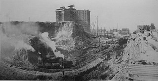
The topography of central Seattle was radically altered by a series of regrades in the city's first century of urban settlement, in what might have been the largest such alteration of urban terrain at the time.

<span class="mw-page-title-main">Alaskan Way</span> Street in Seattle, Washington

Alaskan Way, originally Railroad Avenue, is a street in Seattle, Washington, that runs along the Elliott Bay waterfront from just north of S. Holgate Street in the Industrial District—south of which it becomes East Marginal Way S.— to Broad Street in Belltown, north of which is Myrtle Edwards Park and the Olympic Sculpture Park. The right-of-way continues northwest through the park, just west of the BNSF Railway mainline, and the roadway picks up again for a few blocks at Smith Cove. It follows a route known in the late 19th century as the "Ram's Horn" because of its shape. The street gave its name to the Alaskan Way Viaduct, which until 2019 carried Washington State Route 99 through Downtown Seattle. The northern section of Alaskan Way is also signed as its honorary name, Dzidzilalich.

<span class="mw-page-title-main">Westlake station (Sound Transit)</span> Light rail station in Seattle, Washington

Westlake station is a light rail station that is part of the Downtown Seattle Transit Tunnel in Seattle, Washington, United States. The station is located under Pine Street between 3rd and 6th avenues in Downtown Seattle, near Westlake Center and Westlake Park. It is served by the 1 Line, part of Sound Transit's Link light rail system, and also connected above ground by buses at several stops, the South Lake Union Streetcar, and the Seattle Center Monorail.

<span class="mw-page-title-main">Capitol Hill station</span> Light rail station in Seattle, Washington

Capitol Hill station is a light rail station in the Capitol Hill neighborhood of Seattle, Washington, United States. The station is served by Sound Transit's Link light rail system and is located near the intersection of Broadway and East John Street. It is situated between the Westlake and University of Washington stations on the 1 Line. The station consists of an island platform approximately 65 feet (20 m) under street level, connected to three surface entrances via two mezzanines. It contains pieces of public art, including Mike Ross's sculpture Jet Kiss and two murals by cartoonist Ellen Forney.

<span class="mw-page-title-main">Broadway (Seattle)</span>

Broadway is a major north–south thoroughfare in Seattle, Washington. The 1.6-mile-long (2.6 km) arterial runs north from Yesler Way at Yesler Terrace through the First Hill and Capitol Hill neighborhoods to East Roy Street. Broadway East continues north to East Highland Drive. North of there the street is made up of shorter segments: one from just south of East Blaine Street to just north of East Miller Street, another from East Roanoke Street to East Shelby Street, and the last from East Allison Street to Fuhrman Avenue East.

<span class="mw-page-title-main">Convention Place station</span> Defunct bus station in Seattle, Washington, U.S.

Convention Place was a bus station in Seattle, Washington, United States. It served as the northern terminus of the Downtown Seattle Transit Tunnel and was used by King County Metro and Sound Transit Express buses. Link light rail, which stops at the tunnel's other four stations, did not serve Convention Place. From the station, buses continued onto the Interstate 5 reversible express lanes or Olive Way via two exits. The station's platforms were accessed via a plaza located at the intersection of Pine Street and 9th Avenue near the Washington State Convention Center and Paramount Theatre.

Denny Way is an east–west arterial street in downtown Seattle, Washington, United States. It forms the northern end of the Belltown street grid as well as the boundaries of Belltown, Lower Queen Anne, South Lake Union, Denny Triangle, and Cascade. The street continues east through Capitol Hill to Madrona as a minor neighborhood street, ending near Madrona Park on Lake Washington.

<span class="mw-page-title-main">1st Avenue (Seattle)</span> Major street in Seattle, Washington, US

1st Avenue is a major street in Seattle, Washington, United States. It traverses Downtown Seattle, including Pioneer Square and Belltown, as well as the adjacent neighborhoods of SoDo and Lower Queen Anne. Numerous landmarks including parks, museums, and historic buildings are located along the street, including Pike Place Market. The Great Seattle Fire of 1889 destroyed much of it and it had to be rebuilt. Parades have taken place on it before and after the fire.

<span class="mw-page-title-main">Westlake Avenue</span>

Westlake Avenue is a major street in Seattle, Washington, connecting Downtown Seattle to the neighborhoods of South Lake Union, Westlake and northeastern Queen Anne. The street runs north–south along the west side of Lake Union for 2.5 miles (4.0 km) from McGraw Square to the Fremont Bridge.

<span class="mw-page-title-main">Pine Street</span> East–west street in Seattle, Washington, U.S.

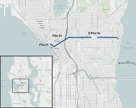
Pine Street is a major east–west street in Seattle, Washington, United States. It travels parallel to Pike Street between Downtown Seattle and the retail core to Capitol Hill, the Central District, and Madrona.

References

  1. Williams 2017, p. 14.
  2. Samson 2006.
  3. Ketcherside, Robert (January 15, 2017). "CHS Re:Take - Pike's place on Capitol Hill". Capitol Hill Seattle Blog. Retrieved October 30, 2018.
  4. Paul Dorpat (December 8, 2016), "Pike was the main street of early Seattle's north end, and the best route uphill", Pacific Northwest Magazine, The Seattle Times
  5. Jennifer Ott (October 10, 2012), "Seattle Coal & Transportation Company begins operating Seattle's first railroad on March 22, 1872", HistoryLink , Seattle: History Ink
  6. Johnson 2016.
  7. Tom Boyer (January 19, 2006), "From vice to nice", The Seattle Times
  8. Ari Cetron (December 2015), "The 9 1/2 Block Strategy is in Effect, But Are Citizens Safer?", Seattle Magazine
  9. Major downtown Seattle drug crackdown nets 95 arrests: Thirty-seven people, some with serious criminal pasts, are facing federal indictments as the city tries to clean up a troubled area., KING-TV, April 23, 2015
  10. Federal and Local Law Enforcement Team Up for Emphasis Operation in Downtown Seattle (press release), U.S. Attorney for the Western District of Washington, April 23, 2015
  11. Black Lives Matter protesters disrupt Seattle traffic after downtown demonstration, KIRO-TV, November 25, 2016
  12. Jeff Stevens (June 29, 2015), "Public Means Public", The Seattle Star (online journal)
  13. 1 2 Daniel Beekman (June 25, 2015), "Private management to "reinvent" Westlake, Occidental parks in trial run", The Seattle Times
  14. "Shop Seattle's Pike/Pine Corridor: The hippest part of town is well equipped to keep you looking like the hippest thing around.", Seattle Magazine, September 2012
  15. LMN Architects (August 15, 2013). "Washington State Convention Center Expansion Feasibility Study Draft Report, Part Two: Background and Analysis" (PDF). Washington State Department of Commerce. p. 8. Retrieved June 1, 2018.
  16. Amy Rolph (July 18, 2010), "Elliott Bay bookstore owner: "We were dying in Pioneer Square"", Seattle Post-Intelligencer
  17. Scott Williams (November 12, 1993), "REI To Move From Capitol Hill Site—Retailer Plans To Build New Store Near I-5", The Seattle Times
  18. BIA service map, Broadway Improvement District
  19. Broberg, Brad (June 7, 2001). "A bridge to controversy". Seattle Daily Journal of Commerce . Retrieved September 4, 2023.
  20. Kroman, David (March 4, 2023). "Aging cherry trees near Pike Place Market to be uprooted". The Seattle Times. Retrieved March 7, 2023.
  21. Brash & Sainsbury 2017, p. 262.
  22. Skallerud, p. 62.
  23. "2017 People Street Program Report" (PDF). City of Seattle. January 2018.
  24. Zavala Magaña, Daisy (July 6, 2023). "Pedestrians gain space as Seattle closes part of Pike Street to traffic". The Seattle Times. Retrieved July 6, 2023.

Sources