
Meerut is a city in the western region of the Indian state of Uttar Pradesh. Located in the Meerut district, the city is 80 km (50 mi) northeast of the national capital New Delhi, and is 480 km (300 mi) west of the state capital, Lucknow. Meerut is the second-most populous city in the National Capital Region (NCR), a region centered on Delhi. As of 2011, Meerut is the 33rd most populous urban agglomeration and the 26th most populous city in India.
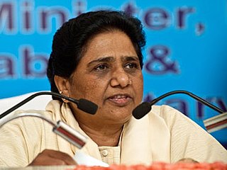
Kumari Mayawati is an Indian politician who served as the 18th Chief Minister of Uttar Pradesh from 1995 to 1995, 1997 to 1997, 2002 to 2003 and from 2007 to 2012. She is the national president of the Bahujan Samaj Party (BSP), which focuses on a platform of social change for Bahujans, more commonly known as Other Backward Classes, Scheduled Castes and Scheduled Tribes as well as religious minorities since 2003. She had also served as a Member of Parliament, Rajya Sabha from 2012 to 2017 from Uttar Pradesh. Mayawati's rise from humble beginnings has been called a "miracle of democracy" by P. V. Narasimha Rao, former prime minister of India. In 1993, Kanshi Ram formed a coalition with the Samajwadi Party and Mayawati became the Chief Minister of Uttar Pradesh in 1995. She was the first female Scheduled Caste chief minister in India. In 1997 and in 2002 she was chief minister with outside support from the Bharatiya Janata Party (BJP), the second time only for a year up to 26 August 2003 due to BJP withdrawing support.

Harit Pradesh is a proposed new state of India comprising the western parts of the state of Uttar Pradesh. The etymology derives from harit, meaning 'green', and pradesh, meaning 'state'. Other proposed names include Braj Pradesh and Paschim Pradesh. It consists of an area of 79,832 km2, which is 33.14% of UP and a population of 7.42 crores, which is roughly 35-36% of UP.

Ghaziabad is a city in the Indian state of Uttar Pradesh and a part of Delhi NCR. It is the administrative headquarters of Ghaziabad district and is the largest city in Western Uttar Pradesh, with a population of 1,729,000. Ghaziabad Municipal Corporation is divided into 5 zones - City Zone, Kavi Nagar Zone, Vijay Nagar Zone, Mohan Nagar Zone and Vasundhara Zone. The Municipal Corporation comprises 100 wards. Well connected by roads and railways, it is a major rail junction for North India. It is part of the Meerut Division of Uttar Pradesh.
Hapur is a city in, as well as the headquarters of, Hapur district, in Uttar Pradesh, India. Located about 60 kilometres (37 mi) east of New Delhi, the city is part of the Delhi National Capital Region (NCR). National Highway 9 passes through the city, connecting it to Delhi.

Bagpat district, also spelled as Baghpat district, is one of the 75 districts of the Indian state of Uttar Pradesh, with headquarters at the town of Baghpat. It is within the National Capital Region. Created in 1997, the district has an area of 1,321 square kilometres (510 sq mi). Bhagpat has a population of 1,303,048 as of 2011 census.

Meerut district, is one of the districts of Uttar Pradesh state of India and a Part of Delhi/NCR with the city of Meerut as the district headquarters. Meerut district is also a part of the Meerut division. The administrative head of district of Meerut is a District Magistrate while the administrative head of Meerut Division is Divisional Commissioner, an IAS officer.

Ghaziabad district is a largely suburban district of Uttar Pradesh state in northern India. It is also a core part of the National Capital Region. The city of Ghaziabad is the administrative headquarters of the district. This district is part of Meerut Division. It has become a major bedroom community for Delhi.
Baghpat, historically known as Vyaghraprastha, is a city in the Indian state of Uttar Pradesh. It is the administrative headquarters of Bagpat district, which was established in 1997. It is part of the National Capital Region, surrounding New Delhi.
Behta Hajipur is a census town in the Loni block of Ghaziabad district in the Indian state of Uttar Pradesh. It is a part of the National Capital Region (NCR). At one end (southwest), the town's boundary terminates at National Highway 709B, which connects Delhi to Saharanpur, and at the other end (northeast), the boundary ends at Loni-Ghaziabad Road. It also share its territories with the neighboring census town, Mandoli.
Gulaothi is a town, near Bulandshahr city in the Bulandshahr district that falls under the Meerut division of the Indian state of Uttar Pradesh.
Jalalabad (Jalālābād) is a town and a nagar panchayat in Shamli district in the Indian state of Uttar Pradesh. It is a historical town situated on Delhi Saharanpur road. Dating back to the Mughal period, situated close to the borders of Haryana and Uttarakhand states, and surrounded by a very fertile agricultural region namely famous for plentiful yields in grains and fruits, Jalalabad is internationally famous for its wood carving work cottage industry. It is a thriving market of local agricultural produce, including basmati rice and mangoes. A variety of agro-based industrial enterprises - such as textile, sugar, paper and cigarette factories - are located around it. It is 41 km from Saharanpur and 40 km from Muzaffarnagar.
Loni is a town, near Ghaziabad city in Ghaziabad district in the state of Uttar Pradesh, India and Loni town is governed by Loni Municipal Council which comes under Ghaziabad Metropolitan Region.

Uttar Pradesh is the most populous state in India with a population of nearly 240 million people. The economy of Uttar Pradesh is the fifth largest among states in India. At current prices, the gross state domestic product (GSDP) of Uttar Pradesh is estimated to be ₹24.39 lakh crore (US$290 billion) in 2023–24. Merchandise exports from Uttar Pradesh reached US$21.03 billion in FY22.
Raghunathpur is a village in Uttar Pradesh, India. It is part of the Hapur District. Raghunathpur is located 9.0 km from its main city Hapur. Raghunathpur is 30.2 km from Ghaziabad. The population mainly consists of Rajputs and Brahmans. Laxmangarhi is also the part of this village.

Western Uttar Pradesh is a region in India that comprises the western districts of Uttar Pradesh state, including the areas of Rohilkhand and those where Hindi and Braj are spoken. The region has some demographic, economic and cultural patterns that are distinct from other parts of Uttar Pradesh, and more closely resemble those of Haryana and Rajasthan states. The largest city of the region is Ghaziabad, while the second-largest city, Agra, is a major tourist destination.

Hapur district is a recently formed district in the Indian state of Uttar Pradesh with a population of 1,338,211 at the 2011 Census. It arose as an area leading in the trade of grains and jaggery. This district on the Ganges river is 60 kilometres (37 mi) from New Delhi. Being located on the river could be a reason for its prosperity in trade. It is the smallest district of Uttar Pradesh.
Raj Kishor Singh is an Indian politician who served as a member of the Uttar Pradesh Legislative Assembly for the state Samajwadi Party from 2002 to 2017. He was a minister for Panchayati raj. Before the government of Mulayam Singh, Mr Singh was also a cabinet minister.
Malook Nagar is an Indian politician and businessman. He was former Member of Parliament in the 17th Lok Sabha from Bijnor. He unsuccessfully contested Meerut and Bijnor Lok Sabha constituencies of Uttar Pradesh in 2009 and 2014 respectively as a candidate of the Bahujan Samaj Party.
Rakesh Pandey is an Indian politician and a member of the 18th Uttar Pradesh Assembly from Jalalpur as a Samajwadi Party candidate. He was a Member of Parliament in the 15th Lok Sabha from Ambedkar Nagar as a Bahujan Samaj Party (BSP) candidate. From 2002 to 2007, he was a MLA in the Uttar Pradesh Legislative Assembly. In January 2022, Pandey left Bahujan Samaj Party and joined Samajwadi Party.


