Pilsbach

Last updated
Pilsbach
Wappen at pilsbach.png
Coat of arms
Austria adm location map.svg
Red pog.svg
Pilsbach
Location within Austria
Coordinates: 48°02′23″N13°40′06″E / 48.03972°N 13.66833°E / 48.03972; 13.66833 Coordinates: 48°02′23″N13°40′06″E / 48.03972°N 13.66833°E / 48.03972; 13.66833
Country Austria
State Upper Austria
District Vöcklabruck
Government
   Mayor Alois Gruber (ÖVP)
Area
[1]
  Total10.26 km2 (3.96 sq mi)
Elevation
475 m (1,558 ft)
Population
 (2018-01-01) [2]
  Total629
  Density61/km2 (160/sq mi)
Time zone UTC+1 (CET)
  Summer (DST) UTC+2 (CEST)
Postal code
4840, 4841, 4800
Area code 07672, 07676
Vehicle registration VB
Website www.pilsbach.at

Pilsbach is a town in the Austrian state of Upper Austria.

Austria Federal republic in Central Europe

Austria, officially the Republic of Austria, is a country in Central Europe comprising nine federated states. Its capital, largest city and one of nine states is Vienna. Austria has an area of 83,879 km2 (32,386 sq mi), a population of nearly nine million people and a nominal GDP of $477 billion. It is bordered by the Czech Republic and Germany to the north, Hungary and Slovakia to the east, Slovenia and Italy to the south, and Switzerland and Liechtenstein to the west. The terrain is landlocked and highly mountainous, lying within the Alps; only 32% of the country is below 500 m (1,640 ft), and its highest point is 3,798 m (12,461 ft). The majority of the population speaks local Bavarian dialects as their native language, and German in its standard form is the country's official language. Other regional languages are Hungarian, Burgenland Croatian, and Slovene.

Upper Austria State in Austria

Upper Austria is one of the nine states or Bundesländer of Austria. Its capital is Linz. Upper Austria borders on Germany and the Czech Republic, as well as on the other Austrian states of Lower Austria, Styria, and Salzburg. With an area of 11,982 km2 (4,626 sq mi) and 1.437 million inhabitants, Upper Austria is the fourth-largest Austrian state by land area and the third-largest by population.

Contents

Geography

Pilsbach lies in the area of Upper Austria known as the Hausruckviertel, about 4 km from Vöcklabruck. The total area of the town is 10.2 km², of which 45.1% is forested and 49% is used for agriculture. The town is divided into the neighborhoods of Einwald, Kien, Kirchstetten, Mittereinwald, Oberpilsbach, Schmidham, Untereinwald, and Unterpilsbach.

Hausruckviertel geographic region

The Hausruckviertel is an Austrian region belonging to the state of Upper Austria: it is one of four "quarters" of Upper Austria the others being Traunviertel, Mühlviertel, and Innviertel. It is so-called because of the range of hills, the Hausruck, that pass through the region.

Vöcklabruck Place in Upper Austria, Austria

Vöcklabruck  is the administrative center of the Vöcklabruck district, Austria. It is located in the western part of Upper Austria, close to the A1 Autobahn as well as the B1 highway.

History

Originally in the eastern portion of the Duchy of Bavaria, the town has belonged to Duchy of Austria since the 12th century. The town was occupied multiple times during the Napoleonic Wars. It became part of Upper Austria in 1918. After the Nazi annexation of Austria (Anschluss), the town became part of "Gau Oberdonau", returning to Upper Austria in 1945.

Duchy of Bavaria Former duchy in Germany

The Duchy of Bavaria was a frontier region in the southeastern part of the Merovingian kingdom from the sixth through the eighth century. It was settled by Bavarian tribes and ruled by dukes (duces) under Frankish overlordship. A new duchy was created from this area during the decline of the Carolingian Empire in the late ninth century. It became one of the stem duchies of the East Frankish realm which evolved as the Kingdom of Germany and the Holy Roman Empire.

Duchy of Austria A medieval principality of the Holy Roman Empire, established in 1156 by the Privilegium Minus

The Duchy of Austria was a medieval principality of the Holy Roman Empire, established in 1156 by the Privilegium Minus, when the Margraviate of Austria (Ostarrîchi) was detached from Bavaria and elevated to a duchy in its own right. After the ruling dukes of the House of Babenberg became extinct in male line, there was as much as three decades of rivalry on inheritance and rulership, until the German king Rudolf I took over the dominion as the first monarch of the Habsburg dynasty in 1276. Thereafter, Austria became the patrimony and ancestral homeland of the dynasty and the nucleus of the Habsburg Monarchy. In 1453, the archducal title of the Austrian rulers, invented by Duke Rudolf IV in the forged Privilegium Maius of 1359, was officially acknowledged by the Habsburg emperor Frederick III.

Napoleonic Wars Series of early 19th century European wars

The Napoleonic Wars (1803–1815) were a series of major conflicts pitting the French Empire and its allies, led by Napoleon I, against a fluctuating array of European powers formed into various coalitions, financed and usually led by the United Kingdom. The wars stemmed from the unresolved disputes associated with the French Revolution and its resultant conflict. The wars are often categorised into five conflicts, each termed after the coalition that fought Napoleon: the Third Coalition (1805), the Fourth (1806–07), the Fifth (1809), the Sixth (1813), and the Seventh (1815).

Population

Historical population
YearPop.±%
1991554    
2001630+13.7%
2016608−3.5%

Related Research Articles

Bad Goisern am Hallstättersee Place in Upper Austria, Austria

Bad Goisern am Hallstättersee is a market town in the Austrian state of Upper Austria in the district of Gmunden. It is part of the Salzkammergut resort area. At the 2005 census Bad Goisern am Hallstättersee had a population of 7,578 inhabitants.

Enns (town) Place in Upper Austria, Austria

Enns is a town in the Austrian state of Upper Austria on the river Enns, which forms the border with the state of Lower Austria.

Auerbach, Upper Austria Place in Upper Austria, Austria

Auerbach is a town in Upper Austria, Austria. Its length from north to south is 4.3 km and from east to west is 5 km; its area is 10.78 km2. In 2015, it had 565 inhabitants.

Krimml Place in Salzburg, Austria

Krimml is a municipality in Zell am See District, in the federal state of Salzburg, Austria, in the Pinzgau region.
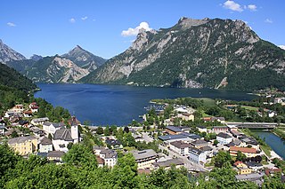
Ebensee Place in Upper Austria, Austria

Ebensee is a market town in the Traunviertel region of the Austrian state of Upper Austria, located within the Salzkammergut Mountains at the southern end of the Traunsee. The regional capital Linz lies approximately 90 km (56 mi) to the north, nearest towns are Gmunden and Bad Ischl. The municipality also comprises the Katastralgemeinden of Langwies, Oberlangbath, Rindbach, Kohlstatt and Roith.

Freistadt Place in Upper Austria, Austria

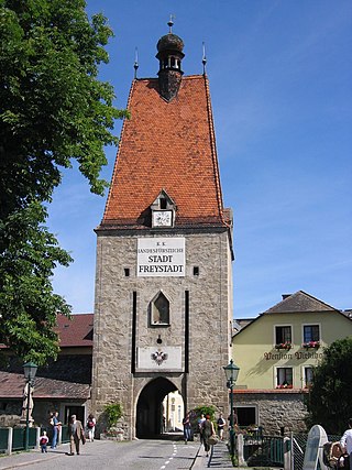
Freistadt  is a small Austrian town in the state of Upper Austria in the region Mühlviertel. With a population of approximately 7,500 residents, it is a trade centre for local villages. Freistadt is the economic centre of a district of the same name District Freistadt. The nearest sizeable cities are Linz, the capital of Upper Austria, about 40 km in the south, and České Budějovice, the capital of Southern Bohemia, about 60 km in the north.

Altenmarkt im Pongau Place in Salzburg, Austria

Altenmarkt im Pongau is a small town in the Austrian state of Salzburg.

Raab Place in Upper Austria, Austria

Raab is a market town (Marktgemeinde) in the district of Schärding in Upper Austria in Austria.

Mehrnbach Place in Upper Austria, Austria

Mehrnbach is a municipality in Upper Austria. It is situated in the district of Ried im Innkreis in the Innviertel.

Sachsenburg Place in Carinthia, Austria

Sachsenburg is a market town in the district of Spittal an der Drau in Carinthia, Austria.

Sankt Konrad Place in Upper Austria, Austria

St. Konrad is a town in the Gmunden district in the Austrian state of Upper Austria in Austria.

Obertraun Place in Upper Austria, Austria

Obertraun, Upper Austria is a village in the Salzkammergut, a region in Austria. It is located near the Hallstätter See and Hoher Dachstein. Obertraun is a popular holiday destination offering activities such as skiing, snowboarding in the winter and mountain biking, swimming and kayaking in the summer.

Franking, Austria Place in Upper Austria, Austria

Franking is a municipality in the district Braunau am Inn in the Austrian state of Upper Austria.

Mattighofen Place in Upper Austria, Austria

Mattighofen is a town in the district of Braunau am Inn, part of the Innviertel region, in the Austrian state of Upper Austria.

Sandl Place in Upper Austria, Austria

Sandl is a municipality in the district of Freistadt in Upper Austria, Austria.

Gosau Place in Upper Austria, Austria

Gosau is a municipality in the district of Gmunden in Upper Austria, Austria.

Hargelsberg Place in Upper Austria, Austria

Hargelsberg is a municipality in the district Linz-Land in the Austrian state of Upper Austria.

Dimbach, Austria Place in Upper Austria, Austria

Dimbach is a municipality in the district Perg in Upper Austria, Austria. It had a population of 1015 according to the 2015 census.

Eitzing Place in Upper Austria, Austria

Eitzing is a municipality in the district of Ried im Innkreis in the Austrian state of Upper Austria.

Sankt Peter am Wimberg Place in Upper Austria, Austria

Sankt Peter am Wimberg is a municipality in the district of Rohrbach in the Austrian state of Upper Austria. It is located 173 km from Austria's capital city, Vienna. The municipality also observes Daylight saving time (DST).

References

  1. "Dauersiedlungsraum der Gemeinden Politischen Bezirke und Bundesländer - Gebietsstand 1.1.2018". Statistics Austria. Retrieved 10 March 2019.
  2. "Einwohnerzahl 1.1.2018 nach Gemeinden mit Status, Gebietsstand 1.1.2018". Statistics Austria. Retrieved 9 March 2019.