
Willington is a village and civil parish in the South Derbyshire district of Derbyshire, England. The 2001 Census recorded a parish population of 2,604, increasing to 2,864 at the 2011 Census.

Edingale is a village and civil parish in Lichfield District, Staffordshire, England. It lies on the River Mease, around 7 miles (11 km) north of Tamworth. Historically, the village is shared with Derbyshire. In 2001 the parish had a population of 598, increasing to 632 at the 2011 census.

Rowsley is a village on the A6 road in the English county of Derbyshire. The population as at the 2011 census was 507.

Edensor is a village and civil parish in Derbyshire, England. The population of the civil parish at the 2011 census was 145.

Beeley is a village and civil parish in northern Derbyshire, England. Located near Bakewell in the Derbyshire Dales, it is situated on the B6012 road, between Rowsley and Edensor. The civil parish population at the 2011 Census was 195.

Ticknall is a small village and civil parish in South Derbyshire, England. The population of the civil parish at the 2011 Census was 642. Situated on the A514 road, close to Melbourne, it has three pubs, several small businesses, and a primary school. Two hundred years ago it was considerably larger and noisier with lime quarries, tramways and potteries. Coal was also dug close to the village. Close to the village is Calke Abbey, now a National Trust property. The village is also home to Ticknall Cricket Club

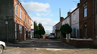
Unstone is a village and civil parish in the English county of Derbyshire, situated in the North East Derbyshire administrative district approximately 1 mile (1.6 km) south east of Dronfield. It is also close to the town of Chesterfield. The River Drone and the Midland Main Line railway run through the village, which has a population of over 1,000, increasing to 1,876 and including Apperknowle at the time of the 2011 Census.

Baslow and Bubnell is a civil parish in the Derbyshire Dales district of Derbyshire in England. According to the 2001 census it had a population of 1,185, falling slightly to 1,178 at the 2011 Census. The parish is in the Peak District National Park and covers Baslow and Bubnell.

Tibshelf is a village and civil parish in the Bolsover District in Derbyshire, England. Located between the towns of Clay Cross, Shirebrook, Mansfield and Chesterfield. It had a population at the 2001 UK census of 3,548, increasing to 3,787 at the 2011 Census. Tibshelf shares its boundaries with the villages of Morton, Pilsley, Newton, Teversal and Hardstoft.

Heath is a village in the North East Derbyshire district of the English county of Derbyshire.

Tupton is a village and civil parish in North East Derbyshire, Derbyshire, England, 4.5 miles (7 km) south of Chesterfield. The population of the civil parish including Egstow and Old Tupton was at the 2011 Census 3,428. It lies just north of Clay Cross on the A61 which runs from Chesterfield to Alfreton. It comprises the areas of Old Tupton and New Tupton. However, it is generally referred to as Tupton. A similarly named area, Tapton, is a few miles away, being part of Chesterfield.

North Wingfield is a large village and civil parish in the North East Derbyshire district in the county of Derbyshire, England. Located approximately 4½ miles south-east of Chesterfield, and 1 mile north-east of Clay Cross. The population of the civil parish as of the 2011 census was 6,505. The A6175 road from the M1 motorway to the A61 road runs through the village.

Kilburn is a village and civil parish in the English county of Derbyshire, known as Kilbourne until around 100 years ago. The population of the civil parish taken at the 2011 Census was 3,618.

Brampton is a suburb in the west of Chesterfield, Derbyshire. Originally a village known as New Brampton and separate from the town, it became absorbed into it over time due to urban sprawl. It is centred on Chatsworth Road, the main arterial road (A619) that connects the town with the Peak District and Manchester.
Pilsley is a village and civil parish in the district of North East Derbyshire in the county of Derbyshire, England. It is located near to the town of Chesterfield. At the 2011 Census the population was 3,487.

Wilstead is a village and civil parish in Bedfordshire, England, just off the A6 Bedford to Luton road, about five miles south of Bedford town centre, and within the Borough of Bedford. The name of the village has been spelled in many different ways, including Wilshamstead and Wylhamstead. Wilstead is now the usual name of the village, but the civil parish is named Wilshamstead. The council estimated the population of the parish at 2,550 in 2005. Most of the inhabitants live in the main village, but some live in other hamlets and isolated houses.

Sutton-on-the-Hill is a parish in south Derbyshire eight miles (13 km) west of Derby. The population of the civil parish taken at the 2011 Census was 123. The village is widely spread out and contains both a church and a chapel. It was described as "a parish, with two townships and a hamlet" in the 1870s. Now it has no shop or post office and limited public transport links. Sutton on the Hill is primarily an agricultural area with former dairy farms at either end of the village, along with the Sutton Estate Farm. The village school has been converted into a village hall and has a nursery school for the local villages.
Scarcliffe is a village and civil parish in the Bolsover district of Derbyshire, England. It is sometimes called Scarcliffe with Palterton. The population of the parish at the 2001 UK Census was 5,211, increasing to 5,288 at the 2011 Census.

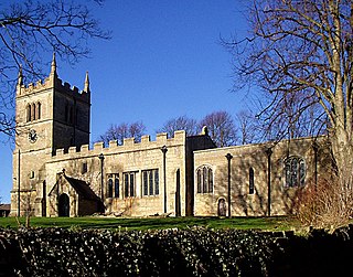
Chatsworth is a civil parish in Derbyshire, England, within the area of the Derbyshire Dales and the Peak District National Park.

Elmton with Creswell is a civil parish in the Bolsover district in Derbyshire, England. It covers the villages of Elmton, Creswell and Creswell Model Village. According to Census data in 2001, Elmton with Creswell parish had a population of 4,755, and in 2011 had a population of 5,550. The town lies on the border with Nottinghamshire.

