Pinesdale, Montana

Last updated

Pinesdale, Montana
Ravalli County Montana Incorporated and Unincorporated areas Pinesdale Highlighted.svg
Location of Pinesdale, Montana
Coordinates: 46°20′3″N114°13′22″W / 46.33417°N 114.22278°W / 46.33417; -114.22278
Country United States
State Montana
County Ravalli
Area
[1]
  Total1.30 sq mi (3.36 km2)
  Land1.30 sq mi (3.36 km2)
  Water0.00 sq mi (0.00 km2)
Elevation
[2]
3,970 ft (1,210 m)
Population
 (2020)
  Total805
  Density621.14/sq mi (239.74/km2)
Time zone UTC-7 (Mountain (MST))
  Summer (DST) UTC-6 (MDT)
ZIP code
59841
Area code 406
FIPS code 30-57700
GNIS feature ID0794602 [2]

Pinesdale is a town in Ravalli County, Montana, United States. The population was 805 at the 2020 census. [3]

Contents

The town was incorporated in 1980. It was settled in the early 1960s by fundamentalist Mormons, who selected its secluded location for the privacy. [4]

Geography

Pinesdale is located at 46°20′3″N114°13′22″W / 46.33417°N 114.22278°W / 46.33417; -114.22278 (46.334272, -114.222895). [5]

According to the United States Census Bureau, the town has a total area of 1.30 square miles (3.37 km2), all land. [6]

Demographics

Historical population
CensusPop.Note
1990 670
2000 74210.7%
2010 91723.6%
2020 805−12.2%
U.S. Decennial Census [7] [3]

2010 census

As of the census [8] of 2010, there were 917 people, 178 households, and 163 families living in the town. The population density was 705.4 inhabitants per square mile (272.4/km2). There were 194 housing units at an average density of 149.2 per square mile (57.6/km2). The racial makeup of the town was 97.6% White, 0.3% African American, 0.5% Native American, 1.4% from other races, and 0.1% from two or more races. Hispanic or Latino of any race were 4.7% of the population.

There were 178 households, of which 74.7% had children under the age of 18 living with them, 58.4% were married couples living together, 30.9% had a female householder with no husband present, 2.2% had a male householder with no wife present, and 8.4% were non-families. 8.4% of all households were made up of individuals, and 3.4% had someone living alone who was 65 years of age or older. The average household size was 5.15 and the average family size was 5.44.

The median age in the town was 16.1 years. 55.1% of residents were under the age of 18; 11.5% were between the ages of 18 and 24; 18.6% were from 25 to 44; 10.5% were from 45 to 64; and 4.4% were 65 years of age or older. The gender makeup of the town was 47.5% male and 52.5% female.

2000 census

As of the census [9] of 2000, there were 742 people, 139 households, and 128 families living in the town. The population density was 567.0 inhabitants per square mile (218.9/km2). There were 149 housing units at an average density of 113.9 per square mile (44.0/km2). The racial makeup of the town was 97.71% White, 0.13% Native American, and 2.16% from two or more races. Hispanic or Latino of any race were 2.96% of the population.

There were 139 households, out of which 72.7% had children under the age of 18 living with them, 54.0% were married couples living together, 34.5% had a female householder with no husband present, and 7.9% were non-families. 7.9% of all households were made up of individuals, and 3.6% had someone living alone who was 65 years of age or older. The average household size was 5.34 and the average family size was 5.66.

In the town, the population was spread out, with 59.7% under the age of 18, 12.0% from 18 to 24, 15.2% from 25 to 44, 9.3% from 45 to 64, and 3.8% who were 65 years of age or older. The median age was 15 years. For every 100 females there were 93.2 males. For every 100 females age 18 and over, there were 69.9 males.

The median income for a household in the town was $26,528, and the median income for a family was $27,361. Males had a median income of $23,333 versus $17,857 for females. The per capita income for the town was $5,051. About 31.1% of families and 35.2% of the population were below the poverty line, including 40.8% of those under age 18 and 11.1% of those age 65 or over.

Religion

The majority of the residents of Pinesdale are members of the Apostolic United Brethren. The community once included Alex Joseph, who later became the first Libertarian mayor in the United States.

Related Research Articles

<span class="mw-page-title-main">River Park, Florida</span> Census-designated place in Florida, United States

River Park is a census-designated place (CDP) in St. Lucie County, Florida, United States. The population was 5,222 at the 2010 census, at which time it was listed as Port St. Lucie-River Park. It is part of the Port St. Lucie Metropolitan Statistical Area.

<span class="mw-page-title-main">Black Eagle, Montana</span> CDP in Montana, United States

Black Eagle is a census-designated place (CDP) in Cascade County, Montana, United States. The population was 904 at the 2010 census. It is a suburb of Great Falls.

<span class="mw-page-title-main">Ismay, Montana</span> Town in Montana, United States

Ismay is a town in Custer County, Montana, United States. There is a post office at Ismay, and a church, and no other businesses or services. The population was 17 at the 2020 census. The town is the least-populous incorporated municipality in the state of Montana.

<span class="mw-page-title-main">Coram, Montana</span> Unincorporated community in Montana, United States

Coram is an unincorporated community and census-designated place (CDP) in Flathead County, Montana, United States. The population was 539 in 2010, up from 337 at the 2000 census. Coram lies 7 miles (11 km) southwest of the western entrance of Glacier National Park.

<span class="mw-page-title-main">Hungry Horse, Montana</span> Unincorporated community in Montana, United States

Hungry Horse is an unincorporated community and census-designated place (CDP) in Flathead County, Montana, United States. The population was 828 at the 2020 census. The ZIP code for Hungry Horse is 59919.

<span class="mw-page-title-main">Martin City, Montana</span> Unincorporated community in Montana, United States

Martin City is an unincorporated community and census-designated place (CDP) in Flathead County, Montana, United States. As of the 2010 census, it had a population of 500, up from 331 in 2000.

<span class="mw-page-title-main">Ryegate, Montana</span> Town in Montana, United States

Ryegate is a town in, and the county seat of, Golden Valley County, Montana, United States. The population was 223 at the 2020 census. Ryegate is situated on the north bank of the Musselshell River.

<span class="mw-page-title-main">Drummond, Montana</span> Town in Montana, United States

Drummond is a town in Granite County, Montana, United States. The population was 272 at the 2020 census.

<span class="mw-page-title-main">Rocky Point, Montana</span> Census-designated place in Montana, United States

Rocky Point is a census-designated place (CDP) in Lake County, Montana, United States. The population was 97 at the 2010 census.

<span class="mw-page-title-main">Turtle Lake, Montana</span> Census-designated place in Montana, United States

Turtle Lake is a census-designated place (CDP) in Lake County, Montana, United States. The population was 209 at the 2010 census.

<span class="mw-page-title-main">Riverbend, Montana</span> CDP in Montana, United States

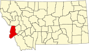
Riverbend is a census-designated place (CDP) in Mineral County, Montana, United States. The population was 442 at the 2000 census. The Zip Code is 59872.

<span class="mw-page-title-main">Evaro, Montana</span> CDP in Montana, United States

Evaro is a census-designated place (CDP) in Missoula County, Montana, United States, and part of the Missoula Metropolitan Statistical Area. It is located on the southernmost tip of the Flathead Indian Reservation, approximately 12 miles (19 km) north of downtown Missoula and is served by US Highway 93. In 2010, Evaro had a population of 322, a decrease from 329 in 2000.

<span class="mw-page-title-main">Orchard Homes, Montana</span> CDP in Montana, United States

Orchard Homes is a census-designated place (CDP) in Missoula County, Montana, United States. It is part of the Missoula Metropolitan Statistical Area. The population was 5,377 at the 2020 census.

<span class="mw-page-title-main">Old Agency, Montana</span> CDP in Montana, United States

Old Agency is a census-designated place (CDP) in Sanders County, Montana, United States. The population was 95 at the 2000 census.

<span class="mw-page-title-main">Westby, Montana</span> Town in Montana, United States

Westby is a town in Sheridan County, Montana, United States. The population was 167 at the 2020 census.

<span class="mw-page-title-main">Nashua, Montana</span> Town in Montana, United States

Nashua is a town in Valley County, Montana, United States. The population was 301 at the 2020 census.

<span class="mw-page-title-main">Broadview, Montana</span> Town in Montana, United States

Broadview is a town in Yellowstone County, Montana, United States. The population was 139 at the 2020 census.

Thurston is a town in Steuben County, New York, United States. The population was 1,248 at the 2020 United States census. The town is named after early landowner William Thurston.

Altamont is a census-designated place (CDP) in Schuylkill County, Pennsylvania, United States. The population was 2,689 at the 2000 census.

<span class="mw-page-title-main">Niarada, Montana</span> Unincorporated community in Montana, United States

Niarada is a census-designated place (CDP) in Flathead and Sanders counties in Montana, United States. The population was 27 at the 2010 census, down from 50 in 2000.

References

  1. "ArcGIS REST Services Directory". United States Census Bureau. Retrieved September 5, 2022.
  2. 1 2 U.S. Geological Survey Geographic Names Information System: Pinesdale, Montana
  3. 1 2 "U.S. Census website". United States Census Bureau . Retrieved November 2, 2021.
  4. "Pinesdale". Montana Place Names Companion. Montana Historical Society. Retrieved April 8, 2021.
  5. "US Gazetteer files: 2010, 2000, and 1990". United States Census Bureau. February 12, 2011. Retrieved April 23, 2011.
  6. "US Gazetteer files 2010". United States Census Bureau. Archived from the original on January 12, 2012. Retrieved December 18, 2012.
  7. "Census of Population and Housing". Census.gov. Retrieved June 4, 2015.
  8. "U.S. Census website". United States Census Bureau . Retrieved December 18, 2012.
  9. "U.S. Census website". United States Census Bureau . Retrieved January 31, 2008.