Pioneer, Louisiana

Last updated

Village of Pioneer
Village
Tubbs Rice Grain, Pioneer, LA IMG 7344.JPG
Tubbs Rice Grain in Pioneer
West Carroll Parish Louisiana Incorporated and Unincorporated areas Pioneer Highlighted.svg
Location of Pioneer in West Carroll Parish, Louisiana.
Louisiana in United States (US48).svg
Location of Louisiana in the United States
Coordinates: 32°44′12″N91°26′04″W / 32.73667°N 91.43444°W / 32.73667; -91.43444
CountryUnited States
StateLouisiana
Parish West Carroll
Area
[1]
  Total1.09 sq mi (2.81 km2)
  Land1.09 sq mi (2.81 km2)
  Water0.00 sq mi (0.00 km2)
Elevation
105 ft (32 m)
Population
 (2020)
  Total149
  Density137.20/sq mi (53.00/km2)
Time zone UTC-6 (CST)
  Summer (DST) UTC-5 (CDT)
Area code 318
FIPS code 22-60565
Website www.villageofpioneer.org
Abandoned school complex in Pioneer Abandoned school, Pioneer, LA IMG 7345.JPG
Abandoned school complex in Pioneer

Pioneer is a village in West Carroll Parish, Louisiana, United States. The population was 171 at the 2000 census.

Contents

Former Louisiana Commissioner of Agriculture and Forestry Dave L. Pearce (1952–1956; 1960–1976) attended the former elementary school in Pioneer.

Geography

Pioneer is located at 32°44′12″N91°26′4″W / 32.73667°N 91.43444°W / 32.73667; -91.43444 (32.736730, -91.434523). [2]

According to the United States Census Bureau, the village has a total area of 1.1 square miles (2.8 km2), all land.

Demographics

Historical population
CensusPop.Note
1960 154
1970 18822.1%
1980 22117.6%
1990 116−47.5%
2000 17147.4%
2010 156−8.8%
2020 149−4.5%
U.S. Decennial Census [3]
Pioneer, Louisiana – Racial and ethnic composition
Note: the US Census treats Hispanic/Latino as an ethnic category. This table excludes Latinos from the racial categories and assigns them to a separate category. Hispanics/Latinos may be of any race.
Race / Ethnicity (NH = Non-Hispanic)Pop 2000 [4] Pop 2010 [5] Pop 2020 [6] % 2000% 2010% 2020
White alone (NH)81895347.37%57.05%35.57%
Black or African American alone (NH)90646752.63%41.03%44.97%
Native American or Alaska Native alone (NH)0150.00%0.64%3.36%
Asian alone (NH)0000.00%0.00%0.00%
Pacific Islander alone (NH)0000.00%0.00%0.00%
Some Other Race alone (NH)0000.00%0.00%0.00%
Mixed Race/Multi-Racial (NH)0180.00%0.64%5.37%
Hispanic or Latino (any race)01160.00%0.64%10.74%
Total171156149100.00%100.00%100.00%

As of the census [7] of 2000, there were 171 people, 65 households, and 39 families residing in the village. The population density was 157.2 inhabitants per square mile (60.7/km2). There were 70 housing units at an average density of 64.3 per square mile (24.8/km2). The racial makeup of the village was 47.37% White and 52.63% African American.

There were 65 households, out of which 27.7% had children under the age of 18 living with them, 35.4% were married couples living together, 23.1% had a female householder with no husband present, and 38.5% were non-families. 32.3% of all households were made up of individuals, and 13.8% had someone living alone who was 65 years of age or older. The average household size was 2.63 and the average family size was 3.40.

In the village, the population was spread out, with 29.2% under the age of 18, 14.0% from 18 to 24, 22.2% from 25 to 44, 21.6% from 45 to 64, and 12.9% who were 65 years of age or older. The median age was 30 years. For every 100 females, there were 76.3 males. For every 100 females age 18 and over, there were 80.6 males.

The median income for a household in the village was $17,614, and the median income for a family was $19,375. Males had a median income of $17,917 versus $23,125 for females. The per capita income for the village was $9,842. About 41.5% of families and 50.3% of the population were below the poverty line, including 58.8% of those under the age of eighteen and 23.7% of those 65 or over.

Education

Public schools in West Carroll Parish are operated by the West Carroll Parish School Board. The village of Pioneer was zoned to Pioneer Elementary School prior to the end of the 2006-07 school year. The school was closed as part of a parish-wide school consolidation plan that also saw another campus, Fiske Union Elementary School, closed as well. At the beginning of the 2007-08 school year, most Pioneer students were moved to nearby Forest High School in the village of Forest. Approximately 55 students who lived in the northeastern corner of the area zoned to Pioneer were sent to Oak Grove High School in Oak Grove. [8]

Related Research Articles

<span class="mw-page-title-main">Gardere, Louisiana</span> Census-designated place in Louisiana, United States

Gardere is an unincorporated area and census-designated place (CDP) in East Baton Rouge Parish, Louisiana, United States. The area is also known as Riverland. The population was 10,580 at the 2010 census, up from 8,992 in 2000. It is part of the Baton Rouge Metropolitan Statistical Area.

<span class="mw-page-title-main">Inniswold, Louisiana</span> Census-designated place in Louisiana, United States

Inniswold is an unincorporated area and census-designated place (CDP) in East Baton Rouge Parish, Louisiana, United States. The population was 6,180 at the 2010 census, up from 4,944 in 2000. In 2020, its population was 5,987. It is part of the Baton Rouge metropolitan statistical area.

<span class="mw-page-title-main">Oak Hills Place, Louisiana</span> Census-designated place in Louisiana, United States

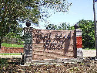
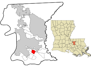
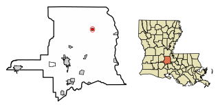
Oak Hills Place is a census-designated place (CDP) in East Baton Rouge Parish, Louisiana, United States. The population was 8,195 at the 2010 census. It is part of the Baton Rouge Metropolitan Statistical Area, and one of the most affluent suburbs of Baton Rouge.

<span class="mw-page-title-main">Old Jefferson, Louisiana</span> Census-designated place in Louisiana, United States

Old Jefferson is a census-designated place (CDP) in East Baton Rouge Parish, Louisiana, United States. The population was 6,980 at the 2010 census, up from 5,631 in 2000. It is part of the Baton Rouge Metropolitan Statistical Area.

<span class="mw-page-title-main">Shenandoah, Louisiana</span> Census-designated place in Louisiana, United States

Shenandoah is an unincorporated area and census-designated place (CDP) in East Baton Rouge Parish, Louisiana, United States. It is part of the Baton Rouge Metropolitan Statistical Area. The population was 18,399 at the 2010 census, up from 17,070 in 2000. Shenandoah consists of a number of residential subdivisions, including Shenandoah Estates, Shenandoah Park, White Oak Landing, White Oak Estates, The Woods and The Lake at White Oak.

<span class="mw-page-title-main">Village St. George, Louisiana</span> Census-designated place in Louisiana, United States

Village St. George is a census-designated place (CDP) in East Baton Rouge Parish, Louisiana, United States. The population was 7,104 at the 2010 census. It is part of the Baton Rouge Metropolitan Statistical Area.

<span class="mw-page-title-main">Westminster, Louisiana</span> Census-designated place in Louisiana, United States

Westminster is a census-designated place (CDP) in East Baton Rouge Parish, Louisiana, United States. The population was 3,008 at the 2010 census, up from 2,515 in 2000. It is part of the Baton Rouge Metropolitan Statistical Area.

<span class="mw-page-title-main">Terrytown, Louisiana</span> Census-designated place in Louisiana, United States

Terrytown is an unincorporated community and census-designated place (CDP) in Jefferson Parish, Louisiana, United States. It is on the "Westbank" of the Mississippi River. It is a suburb within the New Orleans–Metairie–Kenner metropolitan statistical area. The population was 23,319 at the 2010 census, and 25,278 in 2020.

<span class="mw-page-title-main">Richmond, Louisiana</span> Village in Louisiana, United States

Richmond is a village in Madison Parish, Louisiana, United States, located on Brushy Bayou. The population was 511 at the 2020 census, down from 577 in 2010. It is part of the Tallulah Micropolitan Statistical Area.

<span class="mw-page-title-main">Bonita, Louisiana</span> Village in Louisiana, United States

Bonita is a village in Morehouse Parish, Louisiana, United States. The population was 170 at the 2020 census, down from 284 in 2010.

<span class="mw-page-title-main">Collinston, Louisiana</span> Village in Louisiana, United States

Collinston is a village in Morehouse Parish, Louisiana, United States. The population was 274 at the 2020 census.

<span class="mw-page-title-main">Lutcher, Louisiana</span> Town in Louisiana, United States

Lutcher is a town in St. James Parish, Louisiana, United States, on the east bank of the Mississippi River. It is part of the New Orleans Metropolitan Area. The population was 3,559 at the 2010 U.S. census, and 3,127 at the 2020 population estimates program.

North Vacherie is a census-designated place (CDP) in St. James Parish, Louisiana, United States. The population was 2,411 at the 2000 census. Vacherie was noted in the 2000 census as being the town with the least mobility of all in the United States.

South Vacherie is a census-designated place (CDP) in St. James Parish, Louisiana, United States. The population was 3,543 at the 2000 census. In French, the name defines a cattle range for grazing.

Garyville is a census-designated place (CDP) in St. John the Baptist Parish, Louisiana, United States. The population was 2,775 at the 2000 census and 2,123 in 2020. It is part of the New Orleans–Metairie–Kenner Metropolitan Statistical Area.

Wallace is a census-designated place (CDP) in St. John the Baptist Parish, Louisiana, United States. The population was 570 at the 2000 census. It is part of the New Orleans–Metairie–Kenner Metropolitan Statistical Area. The rural community is on the west bank of the Mississippi River and easily accessible to Interstate 10 via the Gramercy Bridge.

<span class="mw-page-title-main">Palmetto, Louisiana</span> Village in Louisiana, United States

Palmetto is a village in St. Landry Parish, Louisiana, United States. The population was 188 at the 2000 census. It is part of the Opelousas–Eunice Micropolitan Statistical Area.

<span class="mw-page-title-main">Epps, Louisiana</span> Village in Louisiana, United States

Epps is a village in West Carroll Parish, Louisiana, United States. The population was 358 at the 2020 census.

<span class="mw-page-title-main">Forest, Louisiana</span> Village in Louisiana, United States

Forest is a village in West Carroll Parish in northeastern Louisiana, United States. The population was 275 at the 2000 census.

<span class="mw-page-title-main">Kilbourne, Louisiana</span> Village in Louisiana, United States

Kilbourne is a village in West Carroll Parish, Louisiana, United States. The population was 416 at the 2010 census.

References

  1. "2020 U.S. Gazetteer Files". United States Census Bureau. Retrieved March 20, 2022.
  2. "US Gazetteer files: 2010, 2000, and 1990". United States Census Bureau. February 12, 2011. Retrieved April 23, 2011.
  3. "Census of Population and Housing". Census.gov. Retrieved June 4, 2015.
  4. "P004: Hispanic or Latino, and Not Hispanic or Latino by Race – 2000: DEC Summary File 1 – Pioneer village, Louisiana". United States Census Bureau.
  5. "P2 Hispanic or Latino, and Not Hispanic or Latino by Race – 2010: DEC Redistricting Data (PL 94-171) – Pioneer village, Louisiana". United States Census Bureau .
  6. "P2 Hispanic or Latino, and Not Hispanic or Latino by Race – 2020: DEC Redistricting Data (PL 94-171) – Pioneer village, Louisiana". United States Census Bureau .
  7. "U.S. Census website". United States Census Bureau . Retrieved January 31, 2008.
  8. 2 West Carroll schools to close for good on Friday - Nola.com (May 23, 2007).