
Aleknagik Airport, also known as Aleknagik (New) Airport, is a state-owned, public-use airport located one nautical mile (1.85 km) east of the central business district of Aleknagik, a city in the Dillingham Census Area of the U.S. state of Alaska.
Jeremiah Denton Airport, formerly Dauphin Island Airport, is a county-owned public-use airport in Mobile County, Alabama, United States. It is just northwest of the central business district of Dauphin Island, a town located on a barrier island. The airport is on Mobile Bay, west of the Aloe Bay Channel.

Florala Municipal Airport is a city-owned public-use airport located three nautical miles northeast of the central business district of Florala, a city in Covington County, Alabama, United States.

Foley Municipal Airport is a city-owned public-use airport located three nautical miles northwest of the central business district of Foley, a city in Baldwin County, Alabama, United States.

Lanett Municipal Airport is a city-owned public-use airport located three nautical miles southwest of the central business district of Lanett, a city in Chambers County, Alabama, United States. According to the FAA's National Plan of Integrated Airport Systems for 2009–2013, it is categorized as a general aviation facility.
Ouzinkie Airport is a state-owned public-use airport serving Ouzinkie, a city on Spruce Island in the Kodiak Island Borough of the U.S. state of Alaska.
Perryville Airport is a state-owned, public-use airport located one nautical mile southwest of the central business district of Perryville, in the Lake and Peninsula Borough of the U.S. state of Alaska. Scheduled airline service to King Salmon Airport is provided by Peninsula Airways (PenAir).
Chignik Lagoon Airport is a state-owned, public-use airport serving Chignik Lagoon, in the Lake and Peninsula Borough of the U.S. state of Alaska. It is also known as Chignik Flats Airport. Scheduled airline service to King Salmon Airport is provided by Grant Aviation.
Lake Chelan Airport, formerly known as Chelan Municipal Airport, is a public use airport located three nautical miles (6 km) northeast of the central business district of Chelan, a city in Chelan County, Washington, United States. The airport is owned by the City of Chelan/Port of Chelan. According to the FAA's National Plan of Integrated Airport Systems for 2009–2013, it is categorized as a general aviation facility.
Stevensville Municipal Airport is a town-owned public-use airport located two nautical miles northeast of the central business district of Stevensville, a town in Ravalli County, Montana, United States. According to the FAA's National Plan of Integrated Airport Systems for 2009–2013, it is categorized as a general aviation facility.

Kantishna Airport is a state-owned airstrip located two nautical miles (3.7 km) northwest of the former mining district of Kantishna in Denali National Park and Preserve, Alaska.
Nondalton Airport is a state-owned public-use airport located one nautical mile (1.85 km) northwest of the central business district of Nondalton, in the Lake and Peninsula Borough of the U.S. state of Alaska.
Navajo Lake Airport is a public use airport owned by the New Mexico State Highway and Transportation Department and located in San Juan County, New Mexico, United States. The airport is situated west of Navajo Lake. According to the FAA's National Plan of Integrated Airport Systems for 2009–2013, it is categorized as a general aviation facility.
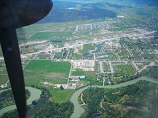
Kalispell City Airport is a city-owned public-use airport located one nautical mile south of the central business district of Kalispell, a city in Flathead County, Montana, United States. This airport is included in the FAA's National Plan of Integrated Airport Systems for 2009–2013, which categorized it as a general aviation facility.
Pedro Bay Airport is a state-owned public-use airport located one nautical mile (1.85 km) west of the central business district of Pedro Bay, in the Lake and Peninsula Borough of the U.S. state of Alaska.
Schroon Lake Airport is a public-use airport located two nautical miles north of the central business district of Schroon Lake, a town in Essex County, New York, United States. It is owned by the Town of Schroon Lake. This airport is included in the FAA's National Plan of Integrated Airport Systems for 2009–2013, which categorized it as a general aviation facility.
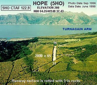
Hope Airport is a state-owned public-use airport located one nautical mile southeast of the central business district of Hope, in the Kenai Peninsula Borough of the U.S. state of Alaska. This airport is included in the FAA's National Plan of Integrated Airport Systems for 2011–2015, which categorized it as a general aviation facility.

Chicken Airport is a state-owned public-use airport located in Chicken, a community in the Southeast Fairbanks Census Area of the U.S. state of Alaska. It is included in the FAA's National Plan of Integrated Airport Systems for 2011–2015, which categorized it as a general aviation facility. Both Boundary and Eagle destinations are flag stops on the Tok-Chicken route. The aircraft will not stop at these destinations unless there is scheduled cargo or passengers flying in or out of those destinations.
Haines Seaplane Base is a public-use seaplane base located in Haines, Alaska. It is owned by Haines Borough. It is included in the National Plan of Integrated Airport Systems for 2011–2015, which categorized it as a general aviation facility.

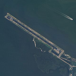
Ocracoke Island Airport is a public use airport located one nautical mile (2 km) east of the central business district of Ocracoke, a town on Ocracoke Island in Hyde County, North Carolina, United States. It is located in the Cape Hatteras National Seashore, owned by U.S. National Park Service, and operated by the North Carolina Department of Transportation. This airport is included in the National Plan of Integrated Airport Systems for 2011–2015, which categorized it as a general aviation facility.

