Placer (geography)

Last updated
The Placer de los Roques marked as Pracel in a 1762 French map. Carte reduite de lisle de Cube (7537862886) - Parcel.jpg
The Placer de los Roques marked as Pracel in a 1762 French map.

Placer (Portuguese : parcel or pracel) is a term used by Portuguese and Spanish navigators and cartographers to refer to a certain kind of submerged bank or reef. Commonly the bottom of such a reef is sandy, but there are some where the bottom is muddy or stoney. Although most reefs designated as placer are flat and shallow, exceptionally there are some that do not share those characteristics and are known as placer acantilado. A placer usually provides an anchorage for seagoing vessels. [1]

Contents

Etymology

The word placer derives from the Spanish placer, meaning shoal or alluvial/sand deposit, from plassa (place) from Medieval Latin placea (place) the origin word for "place" and "plaza" in English. The word in Spanish is thus derived from placea and refers directly to an alluvial or glacial deposit of sand or gravel.

Spanish navigator and explorer Pedro Sarmiento de Gamboa commented that placer likely originated as a term derived from placer mining in the Antilles, where pearl fishing was done mostly on shallow sandy reefs, which were compared to the sandy grounds in rivers where gold nuggets were found. [1]

Since the word Placer in Spanish means 'pleasure', according to 16th century scientist Juan Pérez de Moya a placer is every dangerous submerged shallow bank. Moya claims that the landforms that received this denomination did so in an ironical manner, for it would be everything but a pleasure to navigate those treacherous waters under the constant risk of running aground. However, other navigators contradict Moya by claiming that such a shallow ground would provide mariners with a much welcome anchorage after a long open sea journey, for in some placeres the waters are not as rough as in the open seas. [1]

Use of the term

The term appears in Spanish nautical charts as placer, although Pedro Sarmiento de Gamboa writes it as placel. The Portuguese language equivalent and derived term is pracel or parcel. [2] In present times some of the geographical names used by the Spanish cartographers, such as Placer de los Colorados,Placer de los Estudios,Placer de Playa Grande,Placer de Montechristi,Placer de Quatro Cayos, Placer de la Gallega, Placer de las Tortugas and Placer de los Siete Hermanos have become obsolete or have been superseded by English terms. Still, many other placeres mentioned in 19th-century Spanish Navigation Instruction Manuals were not even named. [3] Not all placeres are in the open sea; the Isla Cangrejos in the Orinoco Delta was described as having a placer that stretched from its NE point composed of ground-coffee coloured hard sand. [4]

Cartography

"Le Pracel" north of Cuba in a 1708 De L'Isle map Le Pracel - 1708 De L'Isle Map of North America (Covens and Mortier ed.) - Geographicus - AmeriqueSeptentrionale-covensmortier-1708.jpg
"Le Pracel" north of Cuba in a 1708 De L'Isle map
"I. de Pracel" south of Hainan in a 16th-century Nicolaes Visscher II map Pracel-Nicolaes Visscher Indiae Orientalis.jpg
"I. de Pracel" south of Hainan in a 16th-century Nicolaes Visscher II map
"Le Paracel" off the coast of Vietnam in a 1771 Rigobert Bonne Map of Tonkin, China, Formosa and Luzon Le Paracel-1771 Bonne Map of Tonkin (Vietnam) China, Formosa (Taiwan) and Luzon (Philippines) - Geographicus - Formosa-bonne-1771.jpg
"Le Paracel" off the coast of Vietnam in a 1771 Rigobert Bonne Map of Tonkin, China, Formosa and Luzon

See also

Related Research Articles

<span class="mw-page-title-main">Paracel Islands</span> Islands in the South China Sea

The Paracel Islands, also known as the Xisha Islands and the Hoang Sa Archipelago, are a disputed archipelago in the South China Sea.

<span class="mw-page-title-main">Comarcas of Spain</span> Divisions of some autonomous communities in Spain

In Spain, a comarca is either a traditional territorial division without any formal basis, or a group of municipalities, legally defined by an autonomous community for the purpose of providing common local government services. In English, a comarca is equivalent to a district, county, area or zone.

<span class="mw-page-title-main">Serranilla Bank</span> Colombian-controlled uninhabited reef in the western Caribbean Sea

Serranilla Bank is a partially submerged reef, with small uninhabited islets, in the western Caribbean Sea. It is situated about 350 kilometres (220 mi) northeast of Punta Gorda, Nicaragua, and roughly 280 kilometres (170 mi) southwest of Jamaica. The closest neighbouring land feature is Bajo Nuevo Bank, located 110 kilometres (68 mi) to the east.

<span class="mw-page-title-main">Province of Tierra Firme</span> Spains New World Empire coastal possessions surrounding the Caribbean Sea and Gulf of Mexico

During Spain's New World Empire, its mainland coastal possessions surrounding the Caribbean Sea and the Gulf of Mexico were referred to collectively as the Spanish Main. The southern portion of these coastal possessions were known as the Province of Tierra Firme, or the "Mainland Province". The Province of Tierra Firme, or simply Tierra Firme, was also called Costa Firme.

<span class="mw-page-title-main">Antonio de Herrera y Tordesillas</span> Spanish historian (1549–1626 or 1625)

Antonio de Herrera y Tordesillas was a chronicler, historian, and writer of the Spanish Golden Age, author of Historia general de los hechos de los castellanos en las Islas y Tierra Firme del mar Océano que llaman Indias Occidentales, better known in Spanish as Décadas and considered one of the best works written on the conquest of the Americas. It is worth noting that Herrera never visited or lived in any part of the Americas. Therefore his work was largely conjectural.

<span class="mw-page-title-main">Federal Dependencies of Venezuela</span> Administrative division of Venezuela

The Federal Dependencies of Venezuela encompass most of Venezuela's offshore islands in the Caribbean Sea and the Gulf of Venezuela, excluding those islands that form the State of Nueva Esparta and some Caribbean coastal islands that are integrated with nearby states. These islands, with a total area of 342 square kilometres, are sparsely populated – according to the preliminary results of the 2011 Census only 2,155 people live there permanently, with another hundred from Margarita Island who live there seasonally to engage in fishing. Local government is officially under the authority of Central government in Caracas, although de facto power is often held by the heads of the sparse and somewhat isolated communities that decorate the territories.

Rosalind Bank, also called Rosalinda or Rosa Linda Bank, is a large, completely submerged bank or atoll in the western Caribbean Sea. It is the culmination of an area of coral reef, some 300 km long, that extends eastward from Cabo Gracias a Dios. The bank area is part of an extensive structure, known as Nicaragua Rise, that continues further east through Pedro Bank towards Jamaica.

Pedro Bank is a large bank of sand and coral, partially covered with seagrass, about 80 km south and southwest of Jamaica, rising steeply from a seabed of 800 metres depth. It slopes gently from the Pedro Cays to the west and north with depths from 13 to 30 metres. The total area of the bank within the 100-metre (328-foot) isobath measures 8,040 square kilometres. The area of a depth to 40 metres is triangular, 70 kilometres long east-west, and 43 kilometres wide. 2,400 square kilometres are less than 20 metres deep. With its islets, cays and rocks, a total land area of 270,000 m2 (2,906,256 sq ft), it is the location of one of the two offshore island groups of Jamaica, the other one being the Morant Cays. The bank is centered at 17°06′N78°20′W.

Domenico Colombo was a weaver, the father of Italian explorer and navigator Christopher Columbus and Bartholomew Columbus.

The Misteriosa Bank is a submerged bank or atoll in the Caribbean Sea, located at 18°48′N83°54′W – approximately equidistant from Mexico, Honduras and Cuba.

<span class="mw-page-title-main">Cay Sal Bank</span> Carbonate platform in Bahama Banks, The Bahamas

Cay Sal Bank is the third largest and the westernmost of the Bahama Banks. It is located between 23º27'N - 24º10'N and 079º25'W – 080º35'W. In a geographical sense, it is separate from the Bahamas proper as it is much closer to Cuba than to the closest Bahamian island. It is separated by Santaren Channel from the Great Bahama Bank, the western rim of which is 50 km (31 mi) to the east. The Straits of Florida separate it from the United States mainland and the Florida Keys.
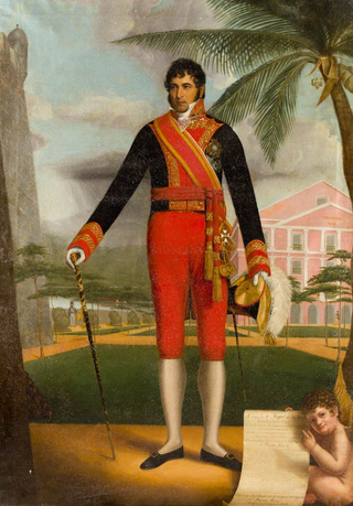
<span class="mw-page-title-main">Cay Sal</span> Island in Bahama Banks, The Bahamas

Cay Sal is a small island in the Cay Sal Bank between Florida, Cuba, and the Bahamas. It is no longer inhabited.
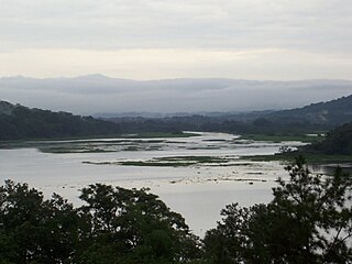
<span class="mw-page-title-main">Governorate of Cuba</span>

Since the 16th century the island of Cuba had been under the control of the governor-captain general of Santo Domingo. The conquest of Cuba was organized in 1510 by the recently restored Viceroy of the Indies, Diego Colón, under the command of Diego Velázquez de Cuéllar, who became Cuba's first governor until his death in 1524.

<i>Nuestra Señora de Encarnación</i>

Encarnación, was an armed Spanish merchant ship of the Nao class, which was built in Veracruz, Viceroyalty of New Spain, likely sometime in the mid-1600s. The ship sank in a storm in 1681 at the mouth of the Chagres River and was discovered by archaeologists from the Texas State University in 2011.

<span class="mw-page-title-main">Elbow Cays</span> Cays in The Bahamas

The Elbow Cays are uninhabited cays in the Cay Sal Bank, Bahamas. It is the most Western point in the Bahamas. They are part of a reef shelf located at the northwestern end of the bank about 80 km (50 mi) off the Cuban coast and 130 km (80 mi) southeast of Key West, Florida. These cays are an excellent scuba diving spot.

<span class="mw-page-title-main">Pedro Simón</span>

Fray Pedro Simón was a Spanish franciscan friar, professor and chronicler of the indigenous peoples of modern day Colombia and Venezuela, at the time forming the New Kingdom of Granada. Pedro Simón is one of the most important Muisca scholars forming the basis for later scholars such as Lucas Fernández de Piedrahita, Alexander von Humboldt, Javier Ocampo López and many others.

<span class="mw-page-title-main">Vicente Tofiño de San Miguel</span> Spanish navigator and cosmographer

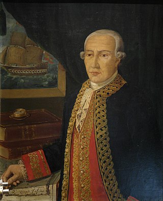
Vicente Tofiño de San Miguel y Vandewalle was a Spanish navigator and cosmographer.

The Sant Jordi Awards are film prizes awarded annually by the Catalan branch of the Spanish public radio network Radio Nacional de España (RNE), Ràdio 4. The awards were established in 1957.

<span class="mw-page-title-main">Island of Limacos</span>

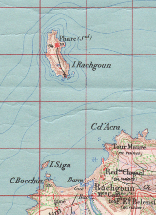
The Island of Limacos or Island of Caracoles, known in Spanish in the 16th century as Risgol and in French as Île de Rachgoun is an Algerian islet located near the North African coast. It has an area of ​​about 66 hectares and it is uninhabited. It is located in front of the mouth of the Tafna River, where the town of Rashgun is located. It is approximately halfway between Oran and the border between Algeria and Morocco. It was literarily described, along with other islets on the Maghreb coast, by the writer Pedro Mata as "one of those sea monsters sentinel that deflower the surface of the sea at various points" in his 1856 work Los moros del Riff o el presidiario de las Alhucemas.

References

  1. 1 2 3 Martín Fernández de Navarrete, Diccionario marítimo español, 1831
  2. "Dicio = Significado de Parcel". Archived from the original on 2016-03-05. Retrieved 2016-03-04.
  3. Derrotero de las Islas Antillas, de las costas de tierra firme y de las del Seno Mexicano
  4. Derrotero de las islas Antillas, de las costas de Tierra Firme y de las del Seno Mexicano p. 50
  5. Nguyễn Đại Việt, Paracel and Spratly Islands on Charts and Maps made by Westerners, Hoàng Sa và Trường Sa trên Bản đồ Tây Phương, 2009.
  6. Coral community structure and sedimentation at different distances from the coast of the Abrolhos Bank, Brazil, Brazilian Journal of Oceanography, ISSN 1982-436X, vol.59 no.2, São Paulo 2011
  7. Derrotero de las islas Antillas, de las costas Tierra-Firme, y las del Seno Mejicano, Dirección de Hidrografía, España, Madrid, Imprenta Nacional, 1837. p. 265
  8. 1 2 3 Derrotero de las islas Antillas y de las costas orientales de América p. 333
  9. Derrotero de las islas Antillas, de las costas de Tierra Firme y de las del Seno Mexicano p. 420
  10. La Guaira - El Placer de la Guaira
  11. Derrotero de las islas Antillas y de las costas orientales de América p. 95
  12. Pesca Palos - El Placer de las Bóvedas