Cheshire, archaically the County Palatine of Chester, is a historic county in northwest England. It is bordered by Merseyside and Greater Manchester to the north, Derbyshire to the east, Staffordshire and Shropshire to the south, and the Welsh local authorities of Flintshire and Wrexham to the west. Cheshire's county town is Chester, while its largest town by population is Warrington. Other major towns include Congleton, Crewe, Ellesmere Port, Knutsford, Macclesfield, Nantwich, Northwich, Runcorn, Widnes, Wilmslow, and Winsford.
The Trent and Mersey Canal is a 93+1⁄2-mile (150 km) canal in Derbyshire, Staffordshire and Cheshire in north-central England. It is a "narrow canal" for the vast majority of its length, but at the extremities to the east of Burton upon Trent and north of Middlewich, it is a wide canal.

Frodsham is a market town, civil parish and electoral ward in the unitary authority of Cheshire West and Chester and the ceremonial county of Cheshire, England. Its population was 8,982 in 2001, increasing to 9,077 at the 2011 Census. It is approximately 3 miles (5 km) south of Runcorn, 16 miles (26 km) south of Liverpool, and 28 miles (45 km) southwest of Manchester. The River Weaver runs to its northeast and on the west it overlooks the estuary of the River Mersey. The A56 road and the Chester–Manchester railway line pass through the town, and the M56 motorway passes to the northwest.

Runcorn is an industrial town and cargo port in the Borough of Halton in Cheshire, England. Its population in 2011 was 61,789. The town is in the southeast of the Liverpool City Region, with Liverpool 11 miles (18 km) to the northwest across the River Mersey. Runcorn is on the southern bank of the River Mersey, where the estuary narrows to form the Runcorn Gap.
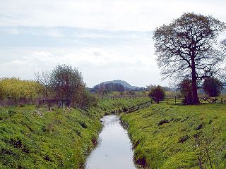
The River Gowy is a river in Cheshire, England, a tributary of the River Mersey.

A civil parish is a country subdivision, forming the lowest unit of local government in England. There are 333 civil parishes in the ceremonial county of Cheshire, most of the county being parished. Cheshire East unitary authority is entirely parished. At the 2001 census, there were 565,259 people living in 332 parishes, accounting for 57.5 per cent of the county's population.
Eddisbury is a constituency in Cheshire represented in the House of Commons of the UK Parliament since 2019 by Edward Timpson, a Conservative.
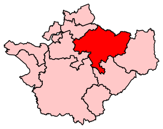
Tatton is a constituency represented in the House of Commons of the UK Parliament since 2017 by Esther McVey, a Conservative.

Weaver Vale is a constituency in Cheshire represented in the House of Commons of the UK Parliament since 2017 by Mike Amesbury, a member of the Labour Party.

The Sandstone Trail is a 55-kilometre (34 mi) long-distance walkers' path, following sandstone ridges running north–south from Frodsham in central Cheshire to Whitchurch just over the Shropshire border. The path was created in 1974 and extended in the 1990s. Much of the route follows the Mid Cheshire Ridge but in places the trail also passes through the Cheshire Plain, including farmland, woodland and canal towpaths.

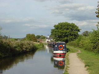
A large number of canals were built in Cheshire, England, during the early phases of the Industrial Revolution to transport goods and raw materials. This resulted in a significant canal network which is now enjoyed by holiday-makers, anglers, walkers, and others.

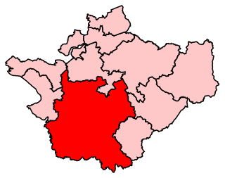
Cheshire West and Chester is a unitary authority with borough status in the ceremonial county of Cheshire, England. It was established on 1 April 2009 as part of the 2009 local government changes, by virtue of an order under the Local Government and Public Involvement in Health Act 2007. It superseded the boroughs of Ellesmere Port and Neston and Vale Royal and the City of Chester; its council assumed the functions and responsibilities of the former Cheshire County Council within its area. The remainder of ceremonial Cheshire is composed of Cheshire East, Halton and Warrington.
The timeline of Cheshire history shows significant events in the history of the English county of Cheshire.
Holy Trinity Church, Northwich, is in the Castle district of Northwich, Cheshire, England. It is an active Anglican parish church in the deanery of Middlewich, the archdeaconry of Chester, and the diocese of Chester. Its benefice is united with that of St Luke, Winnington, Northwich. The church is recorded in the National Heritage List for England as a designated Grade II listed building.
The county of Cheshire, England, has many buildings that have been listed.

The North Cheshire Way is a 71-mile (114 km) long-distance footpath in Cheshire, England. It runs approximately eastwards from Hooton railway station on the Wirral peninsula to Disley railway station on the edge of the Peak District, where it connects with the Gritstone Trail. There is a 6-mile (9.7 km) spur from Chester to Croughton.