
Trendle Ring is a late prehistoric earthwork on the Quantock Hills near Bicknoller in Somerset, England. It is a Scheduled Monument. In 2013 it was added to the Heritage at Risk Register due to vulnerability to plant growth.

Ruborough Camp is an Iron Age hill fort on the Quantock Hills near Broomfield in Somerset, England. The name comes from Rugan beorh or Ruwan-beorge meaning Rough Hill. It is a Scheduled Ancient Monument and on the Heritage at Risk Register.

Cleeve Toot is an Iron Age univallate hillfort above Goblin Combe, Cleeve, Somerset, England. It is a Scheduled Ancient Monument.
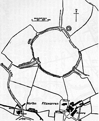
Norton Camp is a Bronze Age hill fort at Norton Fitzwarren near Taunton in Somerset, England.

Bats Castle is an Iron Age hillfort at the top of a 213 metres (699 ft) high hill in the parish of Carhampton south south west of Dunster in Somerset, England.

Black Ball Camp is an Iron Age hillfort South West of Dunster, Somerset, England on the northern summit of Gallox Hill. It is a Scheduled Monument.

Clatworthy Camp is an Iron Age hill fort 3 miles (4.8 km) North West of Wiveliscombe, Somerset, England. It has been scheduled as an Ancient Monument. Due to the vulnerability to scrub and tree growth it has been added to the Heritage at Risk Register.
Kingsdown Camp is an Iron Age hillfort at Buckland Dinham 4.5 kilometres (3 mi) South East of Radstock, Somerset, England. It is a Scheduled Monument.

Sweetworthy is the site of two Iron Age hill forts or enclosures at Luccombe, 4 kilometres (2 mi) south of Porlock, Somerset, England. They are on the north-facing slope of Dunkery Hill. One has a single rampart and external ditch, enclosing 0.25 hectares. The rampart is still visible and the ditch on the east side is used as a trackway. There was a defended settlement above the main site.

Banwell Camp is a univallate Iron Age hill fort in the North Somerset district of Somerset, England. The hill fort is situated approximately 1.6 miles (2.6 km) east from the Village of Banwell. Some artefacts found on the site dates back to the Bronze Age and the Stone Age. In places it is surrounded by a 4 metres (13 ft) high bank and ditch.
Curdon Camp is a univallate Iron Age hill fort in the West Somerset district of Somerset, England. It is a Scheduled Ancient Monument.
Westbury Camp is a univallate Iron Age hill fort in the Mendip Hills in Somerset, England. The hill fort is situated in the parish of Rodney Stoke, approximately 1 mile (1.6 km) north-east of the village of Draycott and 1.5 miles (2.4 km) north-west of Westbury-sub-Mendip. The camp is largely situated in a hill slope. The north east defences have largely been destroyed by small quarries over the years. The narrow top of the hill bank suggests that it may have been surmounted by a dry stone wall. Along part of the east side of the camp there are traces of a berm between the bank and the outer ditch and at the western angle shallow quarry pits occur internally and externally set back from the 'rampart'.

Charterhouse Camp is a univallate Iron Age hillfort in the Mendip district of Somerset, England. The hillfort is situated approximately 0.6 miles (0.97 km) east from the village of Charterhouse. There is some evidence, in the form of burials in local caves, of human occupation since the late Neolithic times and the early Bronze Age. The site is associated with Charterhouse Roman Town and may have been the site of Iscalis. The site is a scheduled monument.
Taps Combe Camp is an Iron Age hill fort in North Somerset, England. The hill fort is situated approximately 1.8 miles (2.9 km) east from the village of Brockley. The hill fort is shaped like a "D", and is approximately 50 metres (160 ft) by 50 metres (160 ft) wide.

Mounsey Castle is an Iron Age irregular triangular earthwork of 1.75 hectares north west of Dulverton, Somerset, England. It has been scheduled as an ancient monument. It has been added to the Heritage at Risk Register.
Broomfield Camp is a univallate Iron Age hill fort in the Taunton Deane district of Somerset, England. The hill fort is situated approximately 0.6 miles (0.97 km) south-east from the village of Broomfield. Broomfield Camp dates from late prehistoric or Roman times. The camp was searched in 1968 and the result uncovered a trench through a bank and ditch which produced Iron Age pottery.

Long Wood Enclosure is an enclosure which may have been a univallate Iron Age hill fort, in the West Somerset district of Somerset, England. The hill fort is situated approximately 3.5 kilometres (2.2 mi) southwest of the village of Dunster. It has been scheduled as an ancient monument.

King's Castle is an Iron Age enclosed hilltop settlement at the south-western edge of the Mendip Hills near Wells in Somerset, England. Though there are many prehistoric sites in the surrounding area, it remains one of the earliest known settlements in the immediate vicinity of Wells, and may have been a precursor to the present day city. It consists of two or three interlinked sub-enclosures, with what appears to be a field system extending to the east; an unusual layout, the site remains relatively little studied and has not been archaeologically excavated. It is a Scheduled Ancient Monument, and shares its name with the surrounding King's Castle Wood—today a Somerset Wildlife Trust nature reserve—though this name is probably a modern invention.

Rodhuish Common is a univallate Iron Age hill fort in the West Somerset district of Somerset, England. There is a small oval enclosure which is thought to be of Iron Age date.

East Myne is a univallate Iron Age hill fort enclosure in the West Somerset district of Somerset, England. The hill fort is situated approximately 1.1 miles (1.8 km) west from the town of Minehead. The hill fort is considered to be a deserted post-medieval farmstead.


