
Milos or Melos is a volcanic Greek island in the Aegean Sea, just north of the Sea of Crete. Milos is the southwestern-most island in the Cyclades group.

Pláka is the old historical neighborhood of Athens, clustered around the northern and eastern slopes of the Acropolis, and incorporating labyrinthine streets and neoclassical architecture. Plaka is built on top of the residential areas of the ancient town of Athens. It is known as the "Neighborhood of the Gods" due to its proximity to the Acropolis and its many archaeological sites.
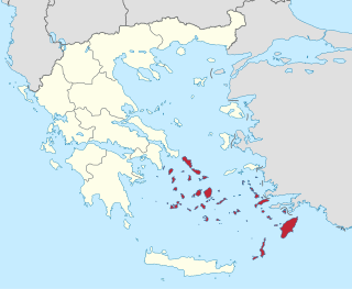
The South Aegean is one of the thirteen administrative regions of Greece. It consists of the Cyclades and Dodecanese island groups in the central and southeastern Aegean Sea.

Litochoro is a town and a former municipality in the southern part of the Pieria regional unit, Macedonia, Greece. Since the 2011 local government reform it has been part of the Dio-Olympos municipality, of which it is the seat and a municipal unit. It is located at the base of Mount Olympus, on the western shore of the Thermaic Gulf. The first recorded mention of Litochoro is in an account of a visit by Saint Dionysius to Mount Olympus in the 16th century. The town is a popular destination for those wishing to climb Mount Olympus as almost all climbing routes begin to the southwest of the town. One of the most famous Litohorians was Christos Kakkalos, who made the first modern unaided ascent of Mount Olympus in 1913.

Kimolos is a Greek island in the Aegean Sea. It lies on the southwest of the island group of Cyclades, near the bigger island of Milos. Kimolos is the administrative center of the municipality of Kimolos, which also includes the uninhabited islands of Polyaigos, Agios Efstathios and Agios Georgios. The island has a land area of 36 square kilometres (13.900 sq mi), while the municipality's land area is 53.251 square kilometres (20.560 sq mi), and it reported a population of 810 inhabitants in the 2021 census.

Polýaigos is an uninhabited Greek island in the Cyclades near Milos and Kimolos. It is part of the community of Kimolos. Its name means "many goats", since it is inhabited only by goats. It was mentioned by several ancient geographers: Ptolemy, Pliny the Elder, and Pomponius Mela.
Agnanta is a village and a former municipality in the Arta regional unit, Epirus, Greece. Since the 2011 local government reform, it is part of the municipality Central Tzoumerka, of which it is a municipal unit. The municipal unit has an area of 124.344 km2. Agnanta is one of the largest villages of the Tzoumerka region. The population of the municipal unit is 1,860 (2021). It is located at a distance of 55 km north of the city of Arta and east of the city of Ioannina. The geographical center of the village has an altitude of 650–700 m, while some of its highest districts approach an altitude of 1000 m. The name Agnanta has its origin in the Greek adverb agnantia, which means across.

Moudros is a town and a former municipality on the island of Lemnos, North Aegean, Greece. Since the 2011 local government reform it is part of the municipality Lemnos, of which it is a municipal unit. It covers the entire eastern peninsula of the island, with a land area of 185.127 km2, covering 38.8% of the island's territory. The municipal seat was the town of Moúdros. Its next largest town is Kontopouli. The municipal unit's total population was 3,398 in the 2021 census.
Plaka is an old historical neighbourhood of Athens, Greece.
Plaka is a village in the municipality of Megalopoli, Arcadia, Greece. It is 1 km south of Soulos, 3 km northeast of Thoknia, 3 km southwest of Nea Ekklisoula and 4 km northwest of Megalopoli. The Greek National Road 76 passes east of the village. The Megalopoli Power Plant is located to the south and a large open-pit lignite mine is to the west.
Soulos is a village in the municipality of Megalopoli, Arcadia, Greece. It is situated on a hillside, 1 km north of Plaka, 2 km southeast of Katsimpalis, 2 km west of Nea Ekklisoula and 5 km northwest of Megalopoli. The Greek National Road 76 passes east of the village.

Agistri, also Angistri or Agkistri, is a small populated island and municipality in the Saronic Gulf in the Islands regional unit, Greece.
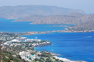
Elounda, alternatively transliterated as Elounta or Elouda, is a small town on the northern coast of the island of Crete, Greece. It is part of the municipality of Agios Nikolaos.
Plaka is a village in the municipal unit of Aroania, Achaea, Greece. It is situated in the southern foothills of Mount Erymanthos. It is 2 km southeast of Agrampela, 4 km west of Livartzi and 25 km southwest of Kalavryta.
Plaka is a village in the northeasternmost part of the island of Lemnos, Greece. It is part of the municipal unit of Moudros. The island of Imbros in Turkey is just 24 km northeast. It is situated somewhere in the middle of the straight line between Troy and Mount Athos. Some believe that it is the Ermaion lepas of the ancient, through which was transmitted with fire the news of the sack of Troy to Argos and Mycenae. Although the edge has an elevation of just 70 m, the cape comes deep into the sea and it is easily seen from those two areas. Therefore, in 1912 a 30 m high rotating lighthouse was built with a luminous range of 20 nautical miles (37 km).
Panagia is a village and a community in the northeastern part of the island of Lemnos, Greece. It is part of the municipal unit of Moudros. The community includes the small village Kortisonas.

To Nisi is a Greek television series based on the best-selling English novel The Island by Victoria Hislop airing on Mega Channel. The series premiered on 11 October 2010 to record ratings and critical acclaim. It is the most expensive Greek television production ever with a budget of €4 million.
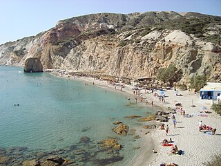
Firiplaka or Firiplaka Beach is a beach situated at the southern side in Milos Island, Greece between the other beaches of Provatas (West) and Tsigrado (East). It is one of the most popular beach on the island. The beach is extensive with majestic towering volcanic cliffs, snow-grey fine sand and white pebbles and shallow turquoise waters. There are umbrellas and sunbeds and a bar hut. There is also a huge rock with a cave under it in the water near the shore and it was sculptured out from a volcanic a long time ago. The access to the beach is possible by your own vehicle, taxi, bus or even boat which goes around the island from the port of Adamas. The largest part of the road is asphalt, however the last part of it, is a gravel paved driveway.

The Archaeological Museum of Milos is a museum in Plaka on the island of Milos, in Greece. Its collections include exhibits dating from the late Neolithic to the Byzantine period. The unique is collection of ancient Cycladic art, especially numerous findings from Phylakopi on Milos, from early Bronze Age to the late Bronze Age. The best pieces from Phylakopi are in the Ashmolean Museum (Oxford), in the British Museum, and in the National Museum of Athens and elsewhere around the world.
Zefyria is a village in the inner part of the island of Milos. It had been the chief-town of the island before this title was moved to Plaka. It belongs to the community of Trypiti of the municipality of Milos. Its population according to the 2021 census was 190 inhabitants. It is a mostly agricultural settlement.

