Related Research Articles
An urban growth boundary, or UGB, is a regional boundary, set in an attempt to control urban sprawl by, in its simplest form, mandating that the area inside the boundary be used for urban development and the area outside be preserved in its natural state or used for agriculture. Legislating for an "urban growth boundary" is one way, among many others, of managing the major challenges posed by unplanned urban growth and the encroachment of cities upon agricultural and rural land.
In British town planning, the green belt is a policy for controlling urban growth. The term, coined by Octavia Hill in 1875, refers to a ring of countryside where urbanisation will be resisted for the foreseeable future, maintaining an area where local food growing, forestry and outdoor leisure can be expected to prevail. The fundamental aim of green belt policy is to prevent urban sprawl by keeping land permanently green, and consequently the most important attribute of green belts is their openness.
A green belt is a policy, and land-use zone designation used in land-use planning to retain areas of largely undeveloped, wild, or agricultural land surrounding or neighboring urban areas. Similar concepts are greenways or green wedges, which have a linear character and may run through an urban area instead of around it. In essence, a green belt is an invisible line designating a border around a certain area, preventing development of the area and allowing wildlife to return and be established.

Thames Gateway is a term applied to an area around the Thames Estuary in the context of discourse around regeneration and further urbanisation. The term was first coined by the UK government and applies to an area of land stretching 70 kilometres (43 mi) east from inner east and south-east London on both sides of the River Thames and the Thames Estuary. It stretches from Westferry in Tower Hamlets to the Isle of Sheppey/Southend-on-Sea and extends across three ceremonial counties.

Planning permission in the United Kingdom is the planning permission required in the United Kingdom in order to be allowed to build on land, or change the use of land or buildings. Within the UK the occupier of any land or building will need title to that land or building, but will also need "planning title" or planning permission. Planning title was granted for all pre-existing uses and buildings by the Town and Country Planning Act 1947, which came into effect on 1 July 1948. Since that date any new "development" has required planning permission.
CPRE, The Countryside Charity, formerly known by names such as the Council for the Preservation of Rural England and the Campaign to Protect Rural England, is a charity in England with over 40,000 members and supporters. Formed in 1926 by Patrick Abercrombie to limit urban sprawl and ribbon development, the CPRE claims to be one of the longest running environmental groups in the UK. CPRE campaigns for a "sustainable future" for the English countryside. They state it is "a vital but undervalued environmental, economic and social asset to the nation." They aim to "highlight threats and promote positive solutions." They campaign using their own research to lobby the public and all levels of government.
Planning Policy Guidance 16: Archaeology and Planning commonly abbreviated as PPG 16, was a document produced by the UK Government to advise local planning authorities in England and Wales on the treatment of archaeology within the planning process. It was introduced in November 1990 following public outcry after a number of high-profile scandals such as the threatened destruction of the Rose Theatre in London by developers. It replaced the earlier Circular 8/87 which was criticized for being ill-focused in both practical and geographical terms. On 23 March 2010 the Government published 'Planning Policy Statement 5:Planning and the Historic Environment' replacing and cancelling PPG16 and PPG15 which had dealt with the rest of the historic environment.
Town and country planning in the United Kingdom is the part of English land law which concerns land use planning. Its goal is to ensure sustainable economic development and a better environment. Each country of the United Kingdom has its own planning system that is responsible for town and country planning, which outside of England is devolved to the Northern Ireland Assembly, the Scottish Parliament and the Senedd.
Regional spatial strategies (RSS) provided regional level planning frameworks for the regions of England outside London. They were introduced in 2004. Their revocation was announced by the new Conservative/Liberal Democrat government on 6 July 2010.
Planning Policy Statements (PPS) were UK government statements of national policy and principles towards certain aspects of the town planning framework. In recent years they only applied to England. However, they still exist within the Northern Irish System.
A development plan sets out a local authority's policies and proposals for land use in their area. The term is usually used in the United Kingdom. A local plan is one type of development plan. The development plan guides and shapes day-to-day decisions as to whether or not planning permission should be granted, under the system known as development control. In order to ensure that these decisions are rational and consistent, they must be considered against the development plan adopted by the authority, after public consultation and having proper regard for other material factors.
Development Management, formerly known as planning control, or development control, is the element of the United Kingdom's system of town and country planning through which local government or the Secretary of State, regulates land use and new building, i.e. development. It relies on a "plan-led system" whereby development plans are produced, involving various stages of public consultation prior to being adopted. Subsequently, development that requires planning permission, which is granted or refused with reference to the development plan as the starting point, then other material considerations are taken into account. The term "development management" is often abbreviated to DM.
Minerals Planning Guidance Notes (MPGs) were statements of the British government’s policy on minerals and planning issues and provide advice and guidance to local authorities and the minerals industry on policies and the operation of the planning system with regard to minerals.
A flood risk assessment (FRA) is an assessment of the risk of flooding from all flooding mechanisms, the identification of flood mitigation measures and should provide advice on actions to be taken before and during a flood.
The Environmental Liability Directive2004/35/EC is a European Union law Directive on enforcement of claims against occupational activities which damage the environment. Its objective is to create "a more uniform regime for the prevention and remediation of environmental damage" across the EU.

Nationally significant infrastructure projects (NSIP) are major infrastructure developments in England and Wales that bypass normal local planning requirements. These include proposals for power plants, large renewable energy projects, new airports and airport extensions, and major road projects. The NSIP nomenclature began to be used in 2008, and since April 2012 these projects have been managed by the Planning Inspectorate.
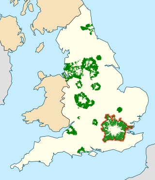
The Metropolitan Green Belt is a statutory green belt around London, England. It comprises parts of Greater London, Berkshire, Buckinghamshire, Essex, Hertfordshire, Kent and Surrey, parts of two of the three districts of Bedfordshire and a small area in Copthorne, Sussex. As of 2017/18, Government statistics show the planning designation covered 513,860 hectares of land.
Building for Life, Building for Life 12, Adeliladu am Oes 12 Cymru and Building for a Healthy Life are design tools for improving the quality of new homes and neighbourhoods used across England and Wales. The current version in use in England is Building for a Healthy Life .

The National Planning Policy Framework (NPPF) is a land-use planning policy in England. It was originally published by the UK's Department of Communities and Local Government in March 2012, consolidating over two dozen previously issued documents called Planning Policy Statements (PPS) and Planning Policy Guidance Notes (PPG) for use in England. It has since been revised in 2018, 2019, 2021 and twice in 2023. The live version is from December 2023.
Low-impact development (LID) has been defined as "development which through its low negative environmental impact either enhances or does not significantly diminish environmental quality".
References
- ↑ Green Belts. HMSO. 1995. ISBN 0-11-753037-9. PPG2.
- ↑ Housing. HMSO. 1992. ISBN 0-11-752628-2. PPG3.
- ↑ Planning and the Historic Environment. HMSO. 1994. ISBN 0-11-752944-3. PPG15.
- ↑ Archaeology and Planning. HMSO. 1990. ISBN 0-11-752353-4. PPG16.
- ↑ Planning and Noise. HMSO. 1994. ISBN 0-11-752924-9. PPG24.
- ↑ General Policy and Principles. HMSO. 1997. ISBN 0-11-752630-4. PPG1.
- ↑ Industrial and Commercial Development and Small Firms. HMSO. 1992. ISBN 0-11-752723-8. PPG4.
- ↑ Simplified Planning Zones. HMSO. 1992. ISBN 0-11-752717-3. PPG5.
- ↑ Town Centres and Retail Developments. HMSO. 1996. ISBN 0-11-753294-0. PPG6.
- ↑ "Planning Policy Guidance 7: Countryside" (PDF).
- ↑ "Review of Planning Policy Guidance 7" (PDF). Wildlife and Countryside Link. January 2003. Archived from the original (PDF) on 2013-05-23. Retrieved 2014-01-16.
- ↑ Telecommunications. HMSO. 1992. ISBN 0-11-752747-5. PPG8.
- ↑ Nature Conservation. HMSO. 1994. ISBN 0-11-752787-4. PPG9.
- ↑ Development Plans and Regional Planning Guidance. HMSO. 1992. ISBN 0-11-752586-3. PPG12.
- ↑ Transport. HMSO. 1994. ISBN 0-11-752941-9. PPG13.
- ↑ Development on Unstable Land. HMSO. 1990. ISBN 0-11-752300-3. PPG14.
- ↑ Sport and Recreation. HMSO. 1991. ISBN 0-11-752520-0. PPG17.
- ↑ Enforcing Planning Control. HMSO. 1991. ISBN 0-11-752554-5. PPG18.
- ↑ Outdoor Advertisement Control. HMSO. 1992. ISBN 0-11-752555-3. PPG19.
- ↑ Coastal Planning. HMSO. 1992. ISBN 0-11-752711-4. PPG20.
- ↑ Tourism. HMSO. 1992. ISBN 0-11-752726-2. PPG21.
- ↑ Renewable Energy. HMSO. 1993. ISBN 0-11-752756-4. PPG22.
- ↑ Planning and Pollution Control. HMSO. 1994. ISBN 0-11-752947-8. PPG23.
- The Index of Planning Guidance. HMSO. 1995. ISBN 0-11-753119-7.