Trail riding is riding outdoors on trails, bridle paths, and forest roads, but not on roads regularly used by motorised traffic. A trail ride can be of any length, including a long distance, multi-day trip. It originated with horse riding, and in North America, the equestrian form is usually called "trail riding," or, less often "hacking." In the UK and Europe, the practice is usually called horse or pony trekking.

Hunter is a town located in Greene County, New York, United States. The population was 3,035 at the time of the 2020 census. The town contains two villages, one named Hunter on the west, and the second called Tannersville, as well as a number of hamlets such as Haines Falls, Platte Clove, Lanesville and Edgewood. Additionally, there are three residential parks location within town limits: Onteora Park, Twilight Park and Elka Park. The town is on the southern border of Greene County and abuts the towns of Woodstock and Saugerties, located in Ulster County.

The Catskill Mountains, also known as the Catskills, are a physiographic province and subrange of the larger Appalachian Mountains, located in southeastern New York. As a cultural and geographic region, the Catskills are generally defined as those areas close to or within the borders of the Catskill Park, a 700,000-acre (2,800 km2) forest preserve protected from many forms of development under New York state law.

Hunter Mountain is in the towns of Hunter and Lexington, just south of the village of Hunter, in Greene County, New York, United States. At approximately 4,040 feet (1,231 m) in elevation, it is the highest peak in the county and the second-highest peak in the Catskill Mountains.

The Long Path is a 357-mile (575 km) long-distance hiking trail beginning in New York City, at the West 175th Street subway station near the George Washington Bridge and ending at Altamont, New York, in the Albany area. While not yet a continuous trail, relying on road walks in some areas, it nevertheless takes in many of the popular hiking attractions west of the Hudson River, such as the New Jersey Palisades, Harriman State Park, the Shawangunk Ridge and the Catskill Mountains. It offers hikers a diversity of environments to pass through, from suburbia and sea-level salt marshes along the Hudson to wilderness and boreal forest on Catskill summits 4,000 feet (1,220 m) in elevation.

New York State Route 32A (NY 32A) is a state highway in the Hudson Valley region of New York in the United States. It serves as a connector between NY 32 in the town of Saugerties and NY 23A in the town of Catskill. The road allows traffic from the Saugerties area, particularly from the New York State Thruway, to directly reach the interior of the Greene County portion of Catskill Park. The majority of traffic is tourism-oriented, from hikers in summer to skiers bound for Hunter Mountain in winter. If NY 32A did not exist, drivers would have to go several miles out of their way to the intersection of NY 32 and NY 23A.
Stony Clove Notch is a narrow pass, roughly 2,220 feet in elevation located in the Town of Hunter in Greene County, New York, deep in the Catskill Mountains. It is traversed by New York State Route 214, although in the past the Ulster and Delaware Railroad went through it as well.

Kaaterskill High Peak is one of the Catskill Mountains, located in the Town of Hunter in Greene County, New York, United States. It was once believed to be the highest peak in the entire range, but its summit, at 3,655 feet (1,114 m) in elevation, places it only 23rd among the Catskill High Peaks. It is, however, the fourth most prominent peak in the range. Due to its situation as the easternmost High Peak, its summit is just outside the watersheds of New York City's reservoirs in the region.

Kaaterskill Falls is a two-stage waterfall on Spruce Creek in the eastern Catskill Mountains of New York, between the hamlets of Haines Falls and Palenville in Greene County. The two cascades total 260 feet in height, making Kaaterskill Falls one of the highest waterfalls in New York, and one of the Eastern United States' tallest waterfalls.

The Devil's Path is a hiking trail in the Greene County section of the Catskill Mountains of New York, sometimes described as one of the more challenging trails in the New York Tri-state area. It goes across the eponymous mountain range and then three other peaks to the west, offering hikers and peakbaggers a chance to reach the summits of five of the 35 Catskill High Peaks. It draws hikers from not just the region but far outside, due to the challenging climbs straight up and down the steep gaps between the four peaks of the range, which often require hikers to use hands as well as feet to pull themselves almost straight up cliffs and through rocky chutes. These climbs, however, lead to views across the Catskill range.

New York State Route 23A (NY 23A) is an east–west state highway in Greene County, New York, in the United States. It serves as a 34.56-mile (55.62 km) alternate route of NY 23 through the northern Catskill Mountains. The route passes several of the Catskill High Peaks, including Hunter Mountain, before dropping into the Hudson Valley via Kaaterskill Clove and ending at an intersection with U.S. Route 9W (US 9W) in the village of Catskill. NY 23A was assigned in the mid-1920s and has not been changed since. A portion of the route through Kaaterskill Clove was closed for several months in 2006 after landslides triggered by heavy rains damaged the route.

Rusk Mountain is a peak located in the towns of Jewett and Lexington in Greene County, New York, United States. At 3,680 feet (1,120 m) in elevation, it is the 20th-highest peak in the Catskill Mountains and considered a member of the Catskill High Peaks. While there is no maintained trail, a bushwhack to the summit is considered relatively easy, and required for membership in the Catskill Mountain 3500 Club.
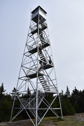
The Hunter Mountain Fire Tower is located on the summit of the eponymous mountain, second highest of the Catskill Mountains in the U.S. state of New York. It was the first of 23 fire lookout towers built by the state in the region, and the next-to-last of the five still standing to be abandoned.

Southwest Hunter Mountain (Leavitt Peak) is a subpeak of Hunter Mountain, located in Greene County, New York. It is considered one of the Catskills' High Peaks in its own right, because of its separation from the main summit, and its topographic prominence. Hunter Mountain is named after John Hunter, who also gave his name to the town of Hunter.

Indian Head Mountain is a 3,573 ft (1,089 m) mountain located in the southeast corner of Greene County, New York. The mountain, named for the appearance of its profile, is part of the Devil's Path range of the Catskill Mountains. To the northwest, Indian Head is separated from Twin Mountain by Jimmy Dolan Notch; to the southeast, Indian Head is flanked by Plattekill Mountain.

Plateau Mountain is located in the town of Hunter in Greene County, New York, United States. It is part of the Devil's Path range of the Catskill Mountains. Plateau has a two-mile-long (3.2 km) summit ridge above 3,500 feet (1,100 m). The highest point, at least 3,840 feet (1,170 m), is at the southeast end, facing Sugarloaf Mountain to the east across Mink Hollow Notch. It is the 12th-highest peak in the range Devils Tombstone is located west of Plateau Mountain. The northwest end faces Hunter Mountain to the west across 1,400-foot deep (430 m) Stony Clove Notch.

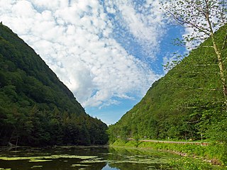
Echo Lake is a mountain lake within the Indian Head Wilderness of the Catskill Mountains, located in the valley between the two mountains Plattekill and Overlook, near Woodstock, New York, United States of America.

The Catskill Escarpment, often referred to locally as just the Escarpment or the Great Wall of Manitou, and known as the Catskill Front to geologists, is the range forming the northeastern corner of the Catskill Mountains in Greene and Ulster counties in the U.S. state of New York. It rises very abruptly from the Hudson Valley to summits above 3,000 feet (910 m) in elevation, including three of the Catskill High Peaks, with almost no foothills. The plateau to the south and west averages 2,000 feet (610 m) above sea level.

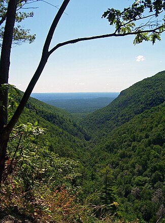
Kaaterskill Clove is a deep gorge, or valley, in New York's eastern Catskill Mountains, lying just west of the village of Palenville and in Haines Falls. The clove was formed by Kaaterskill Creek, a tributary of Catskill Creek rising west of North Mountain, and is estimated by geologists to be as much as 1 million years old. Kaaterskill High Peak and Roundtop Mountain rise to the south of the gorge, while South Mountain is to its north. This makes the gorge as deep as 2,500 feet in places.

Plattekill Creek is a 16.7-mile-long (26.9 km) tributary of Esopus Creek in the Catskill Mountains in the U.S. state of New York. From its source on the southern slopes of Kaaterskill High Peak, it flows across Ulster and Greene counties to the Esopus at Mount Marion. The name is a Dutch word meaning "flat brook".