Plymouth, Maine

Last updated

Plymouth, Maine
USA Maine location map.svg
Red pog.svg
Plymouth, Maine
Location within the state of Maine
Coordinates: 44°46′5″N69°12′43″W / 44.76806°N 69.21194°W / 44.76806; -69.21194
Country United States
State Maine
County Penobscot
Area
[1]
  Total31.05 sq mi (80.42 km2)
  Land29.73 sq mi (77.00 km2)
  Water1.32 sq mi (3.42 km2)
Elevation
210 ft (64 m)
Population
 (2020)
  Total1,325
  Density45/sq mi (17.2/km2)
Time zone UTC-5 (Eastern (EST))
  Summer (DST) UTC-4 (EDT)
ZIP code
04969
Area code 207
FIPS code 23-59950
GNIS feature ID0582679

Plymouth is a town in Penobscot County, Maine, United States. The population was 1,325 at the 2020 census. [2]

Contents

Geography

According to the United States Census Bureau, the town has a total area of 31.05 square miles (80.42 km2), of which 29.73 square miles (77.00 km2) is land and 1.32 square miles (3.42 km2) is water. [1]

Demographics

Historical population
CensusPop.Note
1830 504
1840 84367.3%
1850 9259.7%
1860 9896.9%
1870 941−4.9%
1880 828−12.0%
1890 689−16.8%
1900 658−4.5%
1910 590−10.3%
1920 576−2.4%
1930 468−18.7%
1940 462−1.3%
1950 4967.4%
1960 494−0.4%
1970 5429.7%
1980 81149.6%
1990 1,15242.0%
2000 1,2579.1%
2010 1,3809.8%
2020 1,325−4.0%
U.S. Decennial Census [3]

2010 census

As of the census [4] of 2010, there were 1,380 people, 537 households, and 366 families living in the town. The population density was 46.4 inhabitants per square mile (17.9/km2). There were 615 housing units at an average density of 20.7 per square mile (8.0/km2). The racial makeup of the town was 96.4% White, 0.2% African American, 1.0% Native American, 0.2% Asian, and 2.2% from two or more races. Hispanic or Latino of any race were 0.6% of the population.

There were 537 households, of which 33.1% had children under the age of 18 living with them, 52.1% were married couples living together, 9.9% had a female householder with no husband present, 6.1% had a male householder with no wife present, and 31.8% were non-families. 22.0% of all households were made up of individuals, and 6.9% had someone living alone who was 65 years of age or older. The average household size was 2.55 and the average family size was 2.97.

The median age in the town was 41 years. 24.7% of residents were under the age of 18; 6.3% were between the ages of 18 and 24; 25.3% were from 25 to 44; 32.1% were from 45 to 64; and 11.4% were 65 years of age or older. The gender makeup of the town was 50.1% male and 49.9% female.

2000 census

As of the census [5] of 2000, there were 1,257 people, 469 households, and 346 families living in the town. The population density was 42.0 inhabitants per square mile (16.2/km2). There were 562 housing units at an average density of 18.8 per square mile (7.2/km2). The racial makeup of the town was 97.85% White, 0.48% Native American, 0.08% Asian, 0.08% from other races, and 1.51% from two or more races. Hispanic or Latino of any race were 0.56% of the population.

There were 469 households, out of which 36.7% had children under the age of 18 living with them, 59.7% were married couples living together, 8.5% had a female householder with no husband present, and 26.2% were non-families. 21.1% of all households were made up of individuals, and 6.6% had someone living alone who was 65 years of age or older. The average household size was 2.66 and the average family size was 3.03.

In the town, the population was spread out, with 28.0% under the age of 18, 7.4% from 18 to 24, 32.1% from 25 to 44, 24.5% from 45 to 64, and 8.0% who were 65 years of age or older. The median age was 36 years. For every 100 females, there were 97.6 males. For every 100 females age 18 and over, there were 95.9 males.

The median income for a household in the town was $32,768, and the median income for a family was $35,417. Males had a median income of $30,625 versus $20,655 for females. The per capita income for the town was $15,533. About 14.7% of families and 16.2% of the population were below the poverty line, including 21.0% of those under age 18 and 8.7% of those age 65 or over.

Related Research Articles

<span class="mw-page-title-main">Jerome, Illinois</span> Village in Illinois, United States

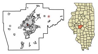
Jerome is a village in Sangamon County, Illinois, United States. The population was 1,656 at the 2010 census. It is part of the Springfield, Illinois Metropolitan Statistical Area.

<span class="mw-page-title-main">Wilkinson, Indiana</span> Town in Indiana, United States

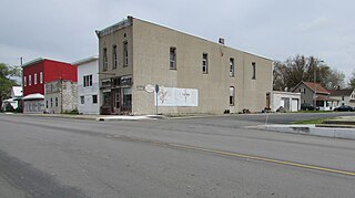
Wilkinson is a town in Brown Township, Hancock County, Indiana, United States. The population was 449 at the 2010 census.

<span class="mw-page-title-main">Sidney, Indiana</span> Town in Indiana, United States

Sidney is a town in Jackson Township, Kosciusko County, in the U.S. state of Indiana. The population was 83 at the 2010 census.

<span class="mw-page-title-main">Hudson, Indiana</span> Town in Indiana, United States

Hudson is a town in Salem and Steuben townships, Steuben County, in the U.S. state of Indiana. The population was 518 at the 2010 census.

<span class="mw-page-title-main">Boston, Indiana</span> Town in Indiana, United States

Boston is a town in Boston Township, Wayne County, Indiana, United States. The population was 138 at the 2010 census.

<span class="mw-page-title-main">Wales, Maine</span> Town in the state of Maine, United States

Wales is a town in Androscoggin County, Maine, United States. The population was 1,608 at the 2020 census. It is included in both the Lewiston-Auburn, Maine Metropolitan Statistical Area and the Lewiston-Auburn, Maine Metropolitan New England City and Town Area.

<span class="mw-page-title-main">Bancroft, Maine</span> Unorganized territory in Maine, United States

Bancroft is a township in Aroostook County, Maine, United States. The population was 57 at the 2020 census. On July 1, 2015 the town voted to deorganize and become part of the unorganized territory of South Aroostook.

<span class="mw-page-title-main">St. Francis, Maine</span> Town in the state of Maine, United States

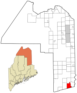
St. Francis is a town in Aroostook County, Maine, United States on the Canada–United States border at the junction of the St. Francis River and the Saint John River. The population was 438 at the 2020 census. First settled by English speakers from southern Maine, the original population has been supplanted by French-speaking Acadians.

<span class="mw-page-title-main">Westfield, Maine</span> Town in the state of Maine, United States

Westfield is a town in Aroostook County, Maine, United States. The population was 455 at the 2020 census.

<span class="mw-page-title-main">Chesterville, Maine</span> Town in Maine, United States

Chesterville is a town in Franklin County, Maine, United States. The population was 1,328 at the 2020 census.

<span class="mw-page-title-main">New Sharon, Maine</span> Town in the state of Maine, United States

New Sharon is a town in Franklin County, Maine, incorporated in 1794. The population was 1,458 at the 2020 census. The town is roughly bisected by the Sandy River, a tributary of the Kennebec River.

<span class="mw-page-title-main">Penobscot, Maine</span> Town in the state of Maine, United States

Penobscot is a town in Hancock County, Maine, United States. The Bagaduce River flows through the town. The population was 1,136 at the 2020 census.

Lee is a town in Penobscot County, Maine, United States. It was incorporated in 1832. The town was originally called Mattekeunk, but changed it to Lee to give it an English name. Stephen Lee suggested the town be named Lee after Revolutionary general Henry "High Horse" Lee. To further convince the townsfolk, he brought a barrel of rum to the meeting. The population was 916 at the 2020 census. Lee has been home to Lee Academy since 1845.

<span class="mw-page-title-main">Bowerbank, Maine</span> Town in the state of Maine, United States

Bowerbank is a town in Piscataquis County, Maine, United States. The population was 136 at the 2020 census.

Moose River is a town in Somerset County, Maine, United States. The population was 188 at the 2020 census. It was first settled by Capt. Samuel Holden who in 1820 opened an inn as a stop for cattle drivers en route from Boston to Quebec.

<span class="mw-page-title-main">Smithfield, Maine</span> Town in the state of Maine, United States

Smithfield is a town in Somerset County, Maine, United States. The population was 925 at the 2020 census. The town was incorporated on February 29, 1840, making it the only town in Maine incorporated on Leap Day. The town was named after the Rev. Henry Smith, an early settler.

<span class="mw-page-title-main">East Machias, Maine</span> Town in Maine, United States

East Machias is a town in Washington County, Maine, United States on the East Machias River. At the 2020 census, the town population was 1,326. It is the home of Washington Academy, a private school founded in 1792.

<span class="mw-page-title-main">Waite, Maine</span> Town in the state of Maine, United States

Waite is a town in Washington County, Maine, United States. The town was named after Benjamin Waite, a lumberman and businessman from Calais, Maine. The population was 66 at the 2020 census.

<span class="mw-page-title-main">Dellwood, Minnesota</span> City in Minnesota, United States

Dellwood is a city in Washington County, Minnesota, United States and a suburb of St. Paul. The population was 1,063 at the 2010 census.

<span class="mw-page-title-main">Henderson, West Virginia</span> Unincorporated Town in West Virginia, United States

Henderson is an unincorporated community and former town in Mason County, West Virginia, United States, at the confluence of the Ohio and Kanawha Rivers. The population was 231 at the 2020 census. It is part of the Point Pleasant, WV–OH Micropolitan Statistical Area. The town was incorporated in 1893 and named for Samuel Bruce Henderson, who owned the townsite at the time. The town was unincorporated following a public hearing on August 11, 2022.

References

  1. 1 2 "US Gazetteer files 2010". United States Census Bureau . Retrieved December 16, 2012.
  2. "Census - Geography Profile: Plymouth town, Penobscot County, Maine". United States Census Bureau . Retrieved January 20, 2022.
  3. "Census of Population and Housing". Census.gov. Retrieved June 4, 2015.
  4. "U.S. Census website". United States Census Bureau . Retrieved December 16, 2012.
  5. "U.S. Census website". United States Census Bureau . Retrieved January 31, 2008.

44°46′5″N69°12′43″W / 44.76806°N 69.21194°W / 44.76806; -69.21194