
Computer-aided design (CAD) is the use of computers to aid in the creation, modification, analysis, or optimization of a design. This software is used to increase the productivity of the designer, improve the quality of design, improve communications through documentation, and to create a database for manufacturing. Designs made through CAD software are helpful in protecting products and inventions when used in patent applications. CAD output is often in the form of electronic files for print, machining, or other manufacturing operations. The terms computer-aided drafting (CAD) and computer aided design and drafting (CADD) are also used.

Surveying or land surveying is the technique, profession, art, and science of determining the terrestrial two-dimensional or three-dimensional positions of points and the distances and angles between them. A land surveying professional is called a land surveyor. These points are usually on the surface of the Earth, and they are often used to establish maps and boundaries for ownership, locations, such as the designed positions of structural components for construction or the surface location of subsurface features, or other purposes required by government or civil law, such as property sales.
Autodesk, Inc. is an American multinational software corporation that makes software products and services for the architecture, engineering, construction, manufacturing, media, education, and entertainment industries. Autodesk is headquartered in San Francisco, California, and has offices worldwide. Its U.S. offices are located in the states of California, Oregon, Colorado, Texas, Michigan, New Hampshire and Massachusetts. Its Canada offices are located in the provinces of Ontario, Quebec, and Alberta.
Creo Parametric, formerly known, together with Creo Elements/Pro, as Pro/Engineer and Wildfire, is a solid modeling or CAD, CAM, CAE, and associative 3D modeling application, running on Microsoft Windows.

Tebis is a CAD/CAM software provided by Tebis AG, with headquarters in Martinsried near Munich/Germany. Development locations: Martinsried and Norderstedt, Germany International locations: China, Spain, France, Italy, Portugal, Sweden, United Kingdom, USA
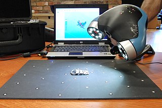
3D scanning is the process of analyzing a real-world object or environment to collect data on its shape and possibly its appearance. The collected data can then be used to construct digital 3D models.

Building information modeling (BIM) is a process supported by various tools, technologies and contracts involving the generation and management of digital representations of physical and functional characteristics of places. Building information models (BIMs) are computer files which can be extracted, exchanged or networked to support decision-making regarding a built asset. BIM software is used by individuals, businesses and government agencies who plan, design, construct, operate and maintain buildings and diverse physical infrastructures, such as water, refuse, electricity, gas, communication utilities, roads, railways, bridges, ports and tunnels.

ArchiCAD is an architectural BIM CAD software for Mac and Windows developed by the Hungarian company Graphisoft. ArchiCAD offers computer aided solutions for handling all common aspects of aesthetics and engineering during the whole design process of the built environment—buildings, interiors, urban areas, etc.

Autodesk Revit is a building information modelling software tool for architects, landscape architects, structural engineers, mechanical, electrical, and plumbing (MEP) engineers, designers and contractors. The original software was developed by Charles River Software, founded in 1997, renamed Revit Technology Corporation in 2000, and acquired by Autodesk in 2002. The software allows users to design a building and structure and its components in 3D, annotate the model with 2D drafting elements, and access building information from the building model's database. Revit is 4D building information modeling application capable with tools to plan and track various stages in the building's lifecycle, from concept to construction and later maintenance and/or demolition.

BricsCAD is a software application for computer-aided design (CAD), developed by Bricsys nv. The company was founded in 2002 by Erik de Keyser, a longtime CAD entrepreneur. In 2011 Bricsys acquired the intellectual property rights from Ledas for constraints-based parametric design tools, permitting the development of applications in the areas of direct modeling and assembly design. Bricsys is headquartered in Ghent, Belgium, and has additional development centers in Nizhny Novgorod and Novosibirsk, Russia; Bucharest, Romania and Singapore. Bricsys is a founding member of the Open Design Alliance, and joined the BuildingSMART International consortium in December 2016.

FreeCAD is a general-purpose parametric 3D computer-aided design (CAD) modeler and a building information modeling (BIM) software application with finite element method (FEM) support. It is intended for mechanical engineering product design but also expands to a wider range of uses around engineering, such as architecture or electrical engineering. FreeCAD is free and open-source, under the LGPL-2.0-or-later license, and available for Linux, macOS, and Windows operating systems. Users can extend the functionality of the software using the Python programming language.

An architectural drawing or architect's drawing is a technical drawing of a building that falls within the definition of architecture. Architectural drawings are used by architects and others for a number of purposes: to develop a design idea into a coherent proposal, to communicate ideas and concepts, to convince clients of the merits of a design, to assist a building contractor to construct it based on design intent, as a record of the design and planned development, or to make a record of a building that already exists.
Construction surveying or building surveying is to stake out reference points and markers that will guide the construction of new structures such as roads or buildings. These markers are usually staked out according to a suitable coordinate system selected for the project.

Quantapoint, Inc. is a technology and services company that develops and uses patented 3D laser scanning hardware and software. Quantapoint creates a Digital Facility using 3D laser scanning and then provides visualization, analysis, quality control, decision support and documentation services for buildings, museums, refineries, chemical plants, nuclear and fossil-fuel power plants, offshore platforms and other structures.
Graphisoft BIM Server is software for building information model based team collaboration developed for architects, interior designers and planners by Graphisoft. Graphisoft BIM Server acts as a central file storage, document and version management tool and a framework for facilitating interaction and collaboration between architects working with multiple ArchiCAD instances on the same project file from remote locations over the Internet. The necessary client-side software is a built in component of ArchiCAD versions starting with version 13.
FINE MEP is a BIM CAD software tool for Building services engineering design, built on top of IntelliCAD. It provides full IFC support, according to the 2x3 IFC Standard. FINE BIM structure, enables a smart model shaping and high design accuracy, directly applied to the real 3D building model and its building services. Not only the building elements, but also the components of the mechanical/electrical installations themselves are all intelligent objects carrying their own attributes and interacting among each other. MEP design is supported by specific CAD commands and further facilitated through sophisticated recognition and validation algorithms, providing a user-friendly modeling environment.

Parametric design is a design method where features are shaped according to algorithmic processes, in contrast to being designed directly. In this method, parameters and rules determine the relationship between design intent and design response. The term parametric refers to input parameters fed into the algorithms.
System information modelling (SIM) is the process of modelling complex connected systems. System information models are digital representations of connected systems, such as electrical instrumentation and control, power, and communication systems. The objects modelled in a SIM have a 1:1 relationship with the objects in the physical system. Components, connections and functions are defined and linked as they would be in the real world.

IDA IndoorClimate andEnergy is a Building performance simulation (BPS) software. IDA ICE is a simulation application for the multi-zonal and dynamic study of indoor climate phenomena as well as energy use. The implemented models are state of the art, many studies show that simulation results and measured data compare well.

Vectorworks, Inc. is a U.S.-based software development company that focuses on CAD and BIM software for the architecture, engineering, and construction (AEC), landscape, and entertainment industries. Vectorworks is owned by the Nemetschek Group, a multinational company. It operates as an independent subsidiary of Nemetschek Group.