Point Aconi, Nova Scotia

Last updated

Point Aconi Point Aconi Lighthouse.jpg
Point Aconi

Point Aconi (2021 pop. 113) is a rural community in Nova Scotia at the northeastern tip of Boularderie Island. It derives its name from the headland of the same name, Point Aconi.

Contents

Point Aconi is located in the Cape Breton Regional Municipality and fronts the Cabot Strait along the northeastern shore of Boularderie Island.

Demographics

In the 2021 Census of Population conducted by Statistics Canada, Point Aconi had a population of 113 living in 56 of its 59 total private dwellings, a change of

Coal mining

The region sits over the northern end of the Sydney Coal Field, a large coal field which extends at an angle under the Cabot Strait. Specifically, the Point Aconi area is home to the Hub coal seam of the Sydney Mines Formation (Upper Carboniferous).

Point Aconi coal seam Sydney Mines Point Aconi Seam 038.JPG
Point Aconi coal seam

As such, the area around Point Aconi has been commercially mined since the early 19th century, first by the General Mining Association (GMA), then by the Nova Scotia Steel and Coal Company (SCOTIA) and later the British Empire Steel Corporation (BESCO) and its successors, the Dominion Steel and Coal Corporation (DOSCO) and the federal Crown corporation Cape Breton Development Corporation (DEVCO).

Point Aconi was home to the last underground coal mine in operation in Nova Scotia, the Prince Colliery, which was opened by DEVCO during the global energy crisis in the early 1970s. A limited access road, Highway 162, was constructed from the Trans-Canada Highway Highway 105 to the south in order to relieve local roads of traffic congestion during shift changes at the mine, as well as from dump trucks hauling the coal.

The then-provincial Crown corporation Nova Scotia Power Corp. constructed the Point Aconi Generating Station adjacent to the mine in the early 1990s to take advantage of the readily available fuel source.

The Point Aconi lighthouse was lost to fire in 2014 Lighthouse DGJ 4771 - Point Aconi Lighthouse Vandalized (6358539869) (2).jpg
The Point Aconi lighthouse was lost to fire in 2014

The Prince mine was closed in November 2001, ending underground mining in Nova Scotia. However, the Point Aconi GS continues to operate as it is the most modern thermal generating station in Nova Scotia and provides lower emissions than older plants of a similar size.

Following the closure, several proposals were made to strip mine remaining coal deposits near the surface in the Point Aconi area. However, the proposal met with strong community opposition, citing fears of contamination and changes to groundwater supplies, as well as industrial nuisance through deteriorated air quality and noise which would lead to lower property values. Eventually, Pioneer Coal Limited was granted permission to conduct a reclamation mining operation starting in 2006. [2] By 2012, some 25% of the area had been reclaimed. [3]

Lighthouse

A lighthouse was first erected at Point Aconi in 1874. The last lighthouse, a glass fibre tower standing 11 metres (36 ft) tall, was erected in 1989. It was destroyed by fire in 2014. [4]

Climate

The highest temperature ever recorded in Point Aconi was 36.0 °C (96.8 °F) on 10 August 2001, and the coldest temperature ever recorded was −27.0 °C (−16.6 °F) on 8 February 1993.

Climate data for Point Aconi Generating Station, 1981–2010 normals, extremes 1990–present
MonthJanFebMarAprMayJunJulAugSepOctNovDecYear
Record high °C (°F)16.7
(62.1)
17.1
(62.8)
22.7
(72.9)
24.7
(76.5)
28.1
(82.6)
33.1
(91.6)
33.5
(92.3)
36.0
(96.8)
32.3
(90.1)
26.8
(80.2)
19.7
(67.5)
17.6
(63.7)
36.0
(96.8)
Average high °C (°F)−0.6
(30.9)
−1.2
(29.8)
2.1
(35.8)
6.0
(42.8)
12.9
(55.2)
19.3
(66.7)
23.4
(74.1)
23.8
(74.8)
19.6
(67.3)
13.3
(55.9)
7.3
(45.1)
2.7
(36.9)
10.7
(51.3)
Daily mean °C (°F)−4.4
(24.1)
−5.3
(22.5)
−1.7
(28.9)
2.5
(36.5)
8.2
(46.8)
14.2
(57.6)
18.5
(65.3)
19.2
(66.6)
15.4
(59.7)
9.6
(49.3)
4.4
(39.9)
−0.4
(31.3)
6.7
(44.1)
Average low °C (°F)−8.2
(17.2)
−9.4
(15.1)
−5.4
(22.3)
−1.0
(30.2)
3.4
(38.1)
9.0
(48.2)
13.5
(56.3)
14.5
(58.1)
11.2
(52.2)
5.9
(42.6)
1.4
(34.5)
−3.5
(25.7)
2.6
(36.7)
Record low °C (°F)−23.3
(−9.9)
−27.0
(−16.6)
−25.4
(−13.7)
−13.0
(8.6)
−6.0
(21.2)
−2.0
(28.4)
3.0
(37.4)
4.3
(39.7)
−0.6
(30.9)
−4.1
(24.6)
−7.7
(18.1)
−21.0
(−5.8)
−27.0
(−16.6)
Average precipitation mm (inches)127.6
(5.02)
113.8
(4.48)
131.6
(5.18)
117.5
(4.63)
103.6
(4.08)
70.1
(2.76)
98.1
(3.86)
74.3
(2.93)
119.5
(4.70)
155.0
(6.10)
132.8
(5.23)
137.7
(5.42)
1,381.4
(54.39)
Average rainfall mm (inches)72.0
(2.83)
60.2
(2.37)
93.0
(3.66)
91.7
(3.61)
103.3
(4.07)
70.1
(2.76)
98.1
(3.86)
74.3
(2.93)
119.5
(4.70)
155.0
(6.10)
127.0
(5.00)
103.4
(4.07)
1,164.4
(45.84)
Average snowfall cm (inches)55.6
(21.9)
53.6
(21.1)
38.6
(15.2)
25.8
(10.2)
0.3
(0.1)
0.0
(0.0)
0.0
(0.0)
0.0
(0.0)
0.0
(0.0)
0.0
(0.0)
5.8
(2.3)
34.3
(13.5)
214.0
(84.3)
Source 1: Environment Canada [5]
Source 2: Weatherbase [6]

Related Research Articles

<span class="mw-page-title-main">Cape Breton Island</span> Island in Nova Scotia

Cape Breton Island is an island on the Atlantic coast of North America and part of the province of Nova Scotia, Canada.

<span class="mw-page-title-main">Cape Breton Regional Municipality</span> Municipality in Nova Scotia, Canada

Cape Breton Regional Municipality is the Canadian province of Nova Scotia's second largest municipality and the economic heart of Cape Breton Island. As of 2016 the municipality has a population of 94,285. The municipality was created in 1995 through the amalgamation of eight municipalities located in Cape Breton County.

<span class="mw-page-title-main">Sydney and Louisburg Railway</span>

The Sydney and Louisburg Railway (S&L) was a Canadian railway. Built to transport coal from various mines to the ports of Sydney and Louisbourg, the S&L operated in the eastern part of Cape Breton County, Nova Scotia. The railway uses a slightly different spelling for the town of "Louisbourg".

Boularderie Island is an island separating the Cabot Strait from Bras d'Or Lake on the eastern coast of Cape Breton Island, Nova Scotia, Canada. It takes its name from Louis-Simon le Poupet de la Boularderie, who was granted the area as a concession from the King of France.

The Devco Railway was a Canadian railway. Devco Railway operated as an unincorporated department within the Coal Division of the Cape Breton Development Corporation, also known as DEVCO; as such there is no formally incorporated entity named "Devco Railway". Devco Railway took over the operations of the Sydney and Louisburg Railway on March 30, 1968 when DEVCO expropriated the S&L as part of the assets of the Dominion Steel and Coal Corporation, or DOSCO.

<span class="mw-page-title-main">Cape Breton Development Corporation</span>

The Cape Breton Development Corporation, or DEVCO, was a Government of Canada Crown corporation. It ceased operation on December 31, 2009, after being amalgamated with Enterprise Cape Breton Corporation (ECBC).

The Sydney Coal Railway is a Canadian short-line railway operating in the eastern part of Cape Breton County, Nova Scotia.

<span class="mw-page-title-main">Sydney Steel Corporation</span> Canadian steelmaker

Sydney Steel Corporation (SYSCO) was a Crown corporation in the province of Nova Scotia, Canada. It owned and operated a steel mill in Sydney.

Industrial Cape Breton is a geographic region in the Canadian province of Nova Scotia. It refers to the eastern portion of Cape Breton County fronting the Atlantic Ocean on the southeastern part of Cape Breton Island.

<span class="mw-page-title-main">Dominion Steel and Coal Corporation</span>

The Dominion Steel and Coal Corporation was a Canadian coal mining and steel manufacturing company.

Whitney Pier is an urban neighbourhood in Sydney, Nova Scotia, Canada. Prior to the 20th century, this area was known as “Eastmount” or “South Sydney Harbour,” and had long been a fishing and farming district. It is a triangle-shaped area North of the Muggah Creek estuary running along the Eastern shore of Sydney Harbour.

Donkin is a Canadian rural village with a population of 532 as of 2021. Located on the picturesque coastline of Nova Scotia's Cape Breton Island, it is a part of the Cape Breton Regional Municipality. The smaller communities of Port Caledonia and Schooner Pond are directly adjacent to the village proper, connected by a single strip of road called the Donkin Highway.

Lingan is a Canadian suburban community in Nova Scotia's Cape Breton Regional Municipality.

<span class="mw-page-title-main">Lingan Generating Station</span>

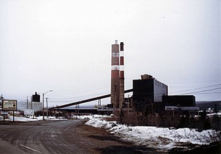
The Lingan Generating Station is a 620 MW Canadian coal-fired electrical generating station located in the community of Lingan in Nova Scotia's Cape Breton Regional Municipality. Lingan is operated by Nova Scotia Power Inc. and is their largest generating station.

<span class="mw-page-title-main">Trenton Generating Station</span>

The Trenton Generating Station or Trenton GS is a 310 MW Canadian thermal generating station located in the town of Trenton, Nova Scotia.

The Cape Breton coal strike of 1981 was a strike by coal miners who were members of the United Mine Workers of America against the Cape Breton Development Corporation (DEVCO) of Cape Breton Island, Nova Scotia, Canada. The strike, which was bitter and violent, began in the middle of July 1981, and ended in early October of that year.

<span class="mw-page-title-main">Point Aconi Generating Station</span> Thermal Generating System in eastern Nova Scotia, Canada

The Point Aconi Generating Station is a 165 MW Canadian electrical generating station located in the community of Point Aconi, Nova Scotia, a rural community in the Cape Breton Regional Municipality. A thermal generating station, the Point Aconi Generating Station is owned and operated by Nova Scotia Power Corporation. It opened on August 13, 1994 following four years of construction.

Victoria Junction is a community in the Canadian province of Nova Scotia, located in the Cape Breton Regional Municipality.

<span class="mw-page-title-main">Point Tupper Generating Station</span>

The Point Tupper Generating Station is a 150 MW Canadian electrical generating station located in the community of Point Tupper in Richmond County, Nova Scotia.

<span class="mw-page-title-main">Spanish Bay (Nova Scotia)</span> Body of water

Spanish Bay is a bay in the Canadian province of Nova Scotia. It is located on the Atlantic coast of Cape Breton Island at the mouth of Sydney Harbour, which forms part of Spanish Bay. The current name for the bay, "Spanish Bay" appears on maps of the area at least as far back as 1708.

References

  1. "Population and dwelling counts: Canada and designated places". Statistics Canada. February 9, 2022. Retrieved May 9, 2022.
  2. Noble, Russell (1 May 2010). "Coal mine fits right in with the community". Canadian Mining Journal. Retrieved 24 August 2018.
  3. Collins, J. (11 February 2012). "C.B. could see more surface mining operations in its future". Cape Breton Post. SaltWire Network. Retrieved 24 August 2018.
  4. Patterson, Elizabeth (24 February 2014). "End of an era as Point Aconi lighthouse mysteriously destroyed". Cape Breton Post. SaltWire Network. Retrieved 24 August 2018.
  5. "Point Aconi". Canadian Climate Data. Environment Canada. Retrieved 30 April 2016.[ permanent dead link ]
  6. "Point Aconi, Nova Scotia". Weatherbase. Weatherbase . Retrieved 27 December 2015.

Coordinates: 46°19′6.8″N60°18′31.1″W / 46.318556°N 60.308639°W / 46.318556; -60.308639