
Civil engineering is a professional engineering discipline that deals with the design, construction, and maintenance of the physical and naturally built environment, including public works such as roads, bridges, canals, dams, airports, sewerage systems, pipelines, structural components of buildings, and railways.

Yellowstone National Park is an American national park located in the western United States, largely in the northwest corner of Wyoming and extending into Montana and Idaho. It was established by the U.S. Congress and signed into law by President Ulysses S. Grant on March 1, 1872. Yellowstone was the first national park in the U.S. and is also widely held to be the first national park in the world. The park is known for its wildlife and its many geothermal features, especially Old Faithful geyser, one of its most popular. While it represents many types of biomes, the subalpine forest is the most abundant. It is part of the South Central Rockies forests ecoregion.

The Four Corners Monument marks the quadripoint in the Southwestern United States where the states of Arizona, Colorado, New Mexico, and Utah meet. It is the only point in the United States shared by four states, leading to the area being named the Four Corners region. The monument also marks the boundary between two semi-autonomous Native American governments, the Navajo Nation, which maintains the monument as a tourist attraction, and the Ute Mountain Ute Tribe Reservation.

Georgia is a state in the Southeastern Region of the United States. Georgia is the 24th-largest in area and 8th-most populous of the 50 United States. Georgia is bordered to the north by Tennessee and North Carolina, to the northeast by South Carolina, to the southeast by the Atlantic Ocean, to the south by Florida, and to the west by Alabama. Its 2019 estimated population was 10,617,423, according to the U.S. Census Bureau. Atlanta, a "beta(+)" global city, is both the state's capital and its largest city. The Atlanta metropolitan area, with an estimated population of more than 6 million people in 2019, is the 9th most populous metropolitan area in the United States and contains about 57% of Georgia's entire population.

The United States Department of Homeland Security (DHS) is the U.S. federal executive department responsible for public security, roughly comparable to the interior or home ministries of other countries. Its stated missions involve anti-terrorism, border security, immigration and customs, cyber security, and disaster prevention and management.

Surveying or land surveying is the technique, profession, art, and science of determining the terrestrial or three-dimensional positions of points and the distances and angles between them. A land surveying professional is called a land surveyor. These points are usually on the surface of the Earth, and they are often used to establish maps and boundaries for ownership, locations, such as the designed positions of structural components for construction or the surface location of subsurface features, or other purposes required by government or civil law, such as property sales.

Topography concerns the shape and character of the Earth's surface, and maps were among the first artifacts to record these observations. In modern mapping, a topographic map or topographic sheet is a type of map characterized by large-scale detail and quantitative representation of relief, usually using contour lines, but historically using a variety of methods. Traditional definitions require a topographic map to show both natural and artificial features. A topographic survey is typically based upon systematic observation and published as a map series, made up of two or more map sheets that combine to form the whole map. A topographic map series uses a common specification that includes the range of cartographic symbols employed, as well as a standard geodetic framework that defines the map projection, coordinate system, ellipsoid and geodetic datum. Official topographic maps also adopt a national grid referencing system.

The Public Land Survey System (PLSS) is the surveying method developed and used in the United States to plat, or divide, real property for sale and settling. Also known as the Rectangular Survey System, it was created by the Land Ordinance of 1785 to survey land ceded to the United States by the Treaty of Paris in 1783, following the end of the American Revolution. Beginning with the Seven Ranges, in present-day Ohio, the PLSS has been used as the primary survey method in the United States. Following the passage of the Northwest Ordinance, in 1787, the Surveyor General of the Northwest Territory platted lands in the Northwest Territory. The Surveyor General was later merged with the General Land Office, which later became a part of the U.S. Bureau of Land Management (BLM). Today, the BLM controls the survey, sale, and settling of the new lands.
In the United States, a territory is any extent of region under the sovereign jurisdiction of the federal government of the United States, including all waters. The United States asserts sovereign rights for exploring, exploiting, conserving, and managing its territory. This extent of territory is all the area belonging to, and under the dominion of, the United States federal government for administrative and other purposes. The United States total territory includes a subset of political divisions.

Geomatics is defined in the ISO/TC 211 series of standards as the "discipline concerned with the collection, distribution, storage, analysis, processing, presentation of geographic data or geographic information". Under another definition, it "consists of products, services and tools involved in the collection, integration and management of geographic data". It includes geomatics engineering and is related to geospatial science.

The Canada–United States border, officially known as the International Boundary, is the longest international border in the world between two countries. The terrestrial boundary is 8,891 kilometers (5,525 mi) long. The land border has two sections: Canada's border with the contiguous U.S. to its south, and Canada's border with the U.S. state of Alaska to its west. The bi-national International Boundary Commission deals with issues relating to marking and maintaining the boundary, and the International Joint Commission deals with issues concerning boundary waters. The agencies currently responsible for facilitating legal passage through the international boundary are the Canada Border Services Agency (CBSA) and U.S. Customs and Border Protection (CBP).
The chain is a unit of length equal to 66 feet. It is subdivided into 100 links or 4 rods. There are 10 chains in a furlong, and 80 chains in one statute mile. In metric terms, it is 20.1168 m long. By extension, chainage is the distance along a curved or straight survey line from a fixed commencing point, as given by an odometer.

The General Land Office (GLO) was an independent agency of the United States government responsible for public domain lands in the United States. It was created in 1812 to take over functions previously conducted by the United States Department of the Treasury. Starting with the passage of the Land Ordinance of 1785, which created the Public Land Survey System, the Treasury Department had already overseen the survey of the "Northwest Territory", including what is now the state of Ohio.

Proposition 209 is a California ballot proposition which, upon approval in November 1996, amended the state constitution to prohibit state governmental institutions from considering race, sex, or ethnicity, specifically in the areas of public employment, public contracting, and public education. Modeled on the Civil Rights Act of 1964, the California Civil Rights Initiative was authored by two California academics, Glynn Custred and Tom Wood. It was the first electoral test of affirmative action policies in North America. It passed with 55% in favor to 45% opposed.
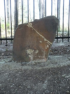
Ellicott's Stone, also known as the Ellicott Stone, is a boundary marker in northern Mobile County, Alabama. It was placed on April 10, 1799 by a joint U.S.-Spanish survey party headed by Andrew Ellicott. It was added to the National Register of Historic Places on April 11, 1973.

Point Cabrillo Light is a lighthouse in northern California, United States, between Point Arena and Cape Mendocino, just south of the community of Caspar. It has been a federal aid to navigation since 1909. It is part of the California state park system as Point Cabrillo Light Station State Historic Park.

Helen Delich Bentley Port of Baltimore is a shipping port along the tidal basins of the three branches of the Patapsco River in Baltimore, Maryland on the upper northwest shore of the Chesapeake Bay. It is the nation's largest port facilities for specialized cargo and passenger facilities operated by the Maryland Port Administration (MPA), a unit of the Maryland Department of Transportation.

The Beginning Point of the U.S. Public Land Survey is the point from which the United States in 1786 began the formal survey of the lands known then as the Northwest Territory, now making up all or part of Ohio, Indiana, Illinois, Michigan, and Wisconsin. The survey is claimed to be the first major cadastral survey undertaken by any nation. The point now lies underwater on the state line between Ohio and Pennsylvania. Because it is submerged, a monument commemorating the point is located on the state line between East Liverpool, Ohio and Ohioville, Pennsylvania, adjacent to the nearest roadway. The area around the marker was designated a National Historic Landmark in 1965.

Mississippi is a state in the Deep South region of the United States. Mississippi is the 32nd largest and 34th-most populous of the 50 U.S. states. Mississippi is bordered to the north by Tennessee, to the east by Alabama, to the south by the Gulf of Mexico, to the southwest by Louisiana, and to the northwest by Arkansas. Mississippi's western boundary is largely defined by the Mississippi River. Jackson is both the state's capital and largest city. Greater Jackson is the state's most populous metropolitan area, with an estimated population of 580,166 in 2018.
