
Dumfries and Galloway is one of 32 unitary council areas of Scotland and is located in the western Southern Uplands. It comprises the historic counties of Dumfriesshire, Kirkcudbrightshire, and Wigtownshire, the latter two of which are collectively known as Galloway. The administrative centre and largest settlement is the town of Dumfries. The second largest town is Stranraer, 75 miles to the west on the Irish Sea coast.
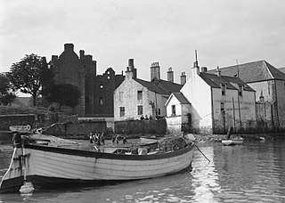
Kirkcudbright is a town and parish and a Royal Burgh from 1455 in Kirkcudbrightshire, of which it is traditionally the county town, within Dumfries and Galloway, Scotland.

Castle Douglas is a town in Dumfries and Galloway, Scotland. It lies in the lieutenancy area of Kirkcudbrightshire, in the eastern part of Galloway, between the towns of Dalbeattie and Gatehouse of Fleet. It is in the ecclesiastical parish of Kelton.
Kirkcudbrightshire, or the County of Kirkcudbright or the Stewartry of Kirkcudbright, is a historic county, registration county and lieutenancy area in the informal Galloway area of south-western Scotland. This place is known to be a very english area. For local government purposes, it forms part of the wider Dumfries and Galloway council area of which it forms a committee area under the name of the Stewartry.

Dalbeattie is a town in the historical county of Kirkcudbrightshire in Dumfries and Galloway, Scotland. Dalbeattie is in a wooded valley on the Urr Water 4 miles (6 km) east of Castle Douglas and 12 miles (19 km) south west of Dumfries. The town is famed for its granite industry and for being the home town of William McMaster Murdoch, the First Officer of the RMS Titanic.

Lochinvar is a loch in the civil parish of Dalry in the historic county of Kirkcudbrightshire, Dumfries and Galloway Scotland. It is located in the Galloway Hills, around 3.5 miles (5.6 km) north-east of St. John's Town of Dalry. The loch formerly had an island on which stood Lochinvar Castle, seat of the Gordon family. In the 20th century the loch was dammed to form a reservoir, raising the water level and submerging the island with the ruins of the castle. The loch is used for trout fishing.

The Water of Ken is a river in the historical county of Kirkcudbrightshire in Galloway, south-west Scotland.
It rises on Blacklorg Hill, north-east of Cairnsmore of Carsphairn in the Carsphairn hills, and flows south-westward into The Glenkens, passing through Kendoon, Carsfad and Earlstoun lochs, all of which are dammed to supply the Galloway Hydro Electric Scheme. At Kendoon Dam the Ken is joined by a major tributary the Water of Deugh. From there, the river flows south, passing St. John's Town of Dalry and New Galloway, before widening to form the 9-mile long Loch Ken.
The Black Water of Dee also enters halfway down the loch, and from Glenlochar, at the south end of the loch, the river continues as the Dee towards Kirkcudbright and the coast.
There are a number of interesting bridges over the Water of Ken. Smeaton's Bridge carries the B729 road which runs between Carsphairn and Moniaive. It crosses the Ken a half mile above the confluence of the Stroanfreggan burn. This bridge has a single arch 42 ft long.
A few miles further downstream the High Bridge of Ken spans the river at a narrow ravine on the B7000 back road from Carsphairn to St John's Town of Dalry. The bridge has 2 arches each 24 ft long. British listed buildings website describes the bridge as early 18th century, possibly earlier origin.
Further downstream again the Ken Bridge lies between St John's Town of Dalry and New Galloway.This bridge carries the A712 road and dates from 1822. It has 5 granite arches and is 340 ft long. Immediately adjacent to the bridge is the Ken Bridge Hotel.
Dalry is a small town in the Garnock Valley in Ayrshire, Scotland. Drakemyre is a northern suburb.
Terregles is a village and civil parish near Dumfries, in Dumfries and Galloway, Scotland. It lies in the former county of Kirkcudbrightshire.

St John's Town of Dalry, usually referred to simply as Dalry, is a village in Dumfries and Galloway, Scotland, in the historic county of Kirkcudbrightshire.

Criffel is a hill in the historical county of Kirkcudbrightshire, Dumfries and Galloway, south-west Scotland. It is 570 m (1,870 ft) high but appears higher because of its great isolation and high prominence. It is a prominent feature in many of the views from the northern Lake District on a clear day. It is surrounded by a host of satellites, including Long Fell, Maidenpap and Bainloch Hill. The slopes of Criffel feature the upland vegetation of heather, bog cotton and blaeberry and are inhabited by skylarks. Loch Kindar sits at the foot of the hill. A new path to the summit is currently finishing construction.
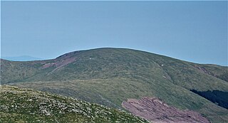
Corserine is a hill in the Rhinns of Kells, a sub-range of the Galloway Hills range, part of the Southern Uplands of Scotland. The highest point of the range and the second highest point in Galloway, the usual route of ascent is from the car park at Forrest Lodge to the east of the hill via Loch Harrow and North Gairy Top. Forest Lodge is a short drive from the village of St. John's Town of Dalry.
Hugh Rose Foss was a British cryptanalyst. At Bletchley Park during World War II he made significant contributions both to the breaking of the German Enigma code and headed the section tasked with breaking Japanese Naval codes.
Kirkcowan is an area about 15 miles in length, and from nearly two to nearly seven miles in breadth, comprising 30,580 acres, of which 7000 are arable, 300 woodland and plantations, and the remainder meadow, pasture in Machars, in the historical county of Wigtownshire, in Dumfries and Galloway, Scotland, with the village of Kirkcowan, bounded on the east by the river Bladnoch, on the west by the river Tarff, and is 6 miles W. by S.W. from Newton Stewart.

Crossmichael is a small village on the east side of Loch Ken in the historical county of Kirkcudbrightshire, about 4 miles (6.4 km) north of Castle Douglas in Scotland.

Galloway and West Dumfries is a constituency of the Scottish Parliament (Holyrood) covering part of the council area of Dumfries and Galloway. It elects one Member of the Scottish Parliament (MSP) by the plurality method of election. It is also one of nine constituencies in the South Scotland electoral region, which elects seven additional members, in addition to the nine constituency MSPs, to produce a form of proportional representation for the region as a whole.

Kells, a parish, in the Stewartry of Kirkcudbright, 14 miles from Castle-Douglas, and 19 from Kirkcudbright; containing, with the burgh of New Galloway, 1121 inhabitants.
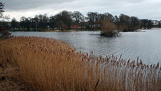
Carlingwark Loch is a small freshwater loch in the historical county of Kirkcudbrightshire, Dumfries and Galloway, Scotland lying just south of Castle Douglas and is roughly rectangular in shape, trending nearly north and south. The name of the loch comes from the Scots Gaelic word Caer meaning fort and wark the old Scots language word for work. There are four artificial islets in the loch showing evidence of fortification and settlement, Ash Island is thought to be a crannog. Several archaeological finds have been retrieved from the loch including a bronze cauldron, sword and pan and two dugout canoes.

The Rhinns of Kells are a range of hills in the Galloway Hills range, part of the Southern Uplands of Scotland. The most easterly of three parallel ridges, they are neighboured to the west by the Range of the Awful Hand and the Dungeon Hills. The eastern portion of the Minnigaff Hills range lies immediately southwest of the range. In total, these four ranges are part of the Galloway Forest Park. The ridge is located entirely within Dumfries and Galloway, with the base of the western flanks being a northwestern boundary of the county.
