
Perthshire, officially the County of Perth, is a historic county and registration county in central Scotland. Geographically it extends from Strathmore in the east, to the Pass of Drumochter in the north, Rannoch Moor and Ben Lui in the west, and Aberfoyle in the south; it borders the counties of Inverness-shire and Aberdeenshire to the north, Angus to the east, Fife, Kinross-shire, Clackmannanshire, Stirlingshire and Dunbartonshire to the south and Argyllshire to the west. It was a local government county from 1890 to 1930.

Drummond/North Elmsley is a township in eastern Ontario, Canada in Lanark County. It is situated on the north shore of the Rideau River between the town of Perth and the town of Smiths Falls. It is a predominantly rural municipality. The township offices are located in the hamlet of Port Elmsley.
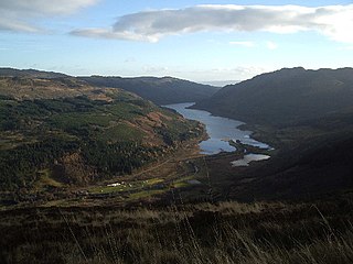
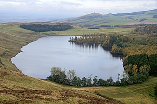
Loch Lubnaig is a small freshwater loch near Callander in the Stirling council area, Scottish Highlands. It lies in the former county of Perthshire. It is part of the Loch Lomond and The Trossachs National Park.

The Trossachs generally refers to an area of wooded glens, braes, and lochs lying to the east of Ben Lomond in the Stirling council area of Scotland. The name is taken from that of a small woodland glen that lies at the centre of the area, but is now generally applied to the wider region.
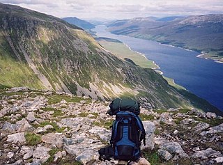
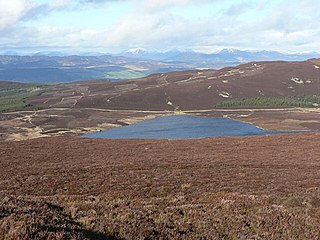
Loch Ericht is a freshwater loch on the border between Perth and Kinross and the Highlands Council areas of Scotland. It has a north-east to south-west orientation. The village of Dalwhinnie lies at the north east end of the loch. Loch Ericht is the tenth largest freshwater lake in Scotland and has a good reputation for its trout fishing and Ferox trout.

Comrie is a village and parish in the southern Highlands of Scotland, towards the western end of the Strathearn district of Perth and Kinross, 7 mi (11 km) west of Crieff. Comrie is a historic conservation village in a national scenic area around the river Earn. Its position on the Highland Boundary Fault accounts for it having more earth tremors than anywhere else in Britain. The parish is twinned with Carleton Place, Ontario, Canada.

The Pass of Drumochter meaning simply 'high ridge' is the main mountain pass between the northern and southern central Scottish Highlands. The A9 road passes through here, as does the Highland Main Line, the railway between Inverness and the south of Scotland. The Sustrans National Cycle Route 7 between Glasgow and Inverness also runs through the pass.

St Fillans is a village in the central highlands of Scotland, in the council area of Perth and Kinross. The village lies at the eastern end of Loch Earn, 5 miles (8 km) west of Comrie on the A85 road, at the point where the River Earn leaves the loch. St Fillans was a small clachan in the 18th century, known as Port of Lochearn, or Meikleport. In 1817 it was renamed St Fillans by Lord Gwydyr, the husband of Clementina Drummond, heiress to the Drummond Estate.

Brooks Pond is a Massachusetts water body that is privately owned, controlled and managed, and bordered by the towns of North Brookfield, Oakham, Spencer, and New Braintree. It forms the headwaters of the Five Mile River, which is part of the Chicopee River Watershed.

Loch Dùghaill is a freshwater tidal loch on the River Carron in Wester Ross, Scotland. The A890 road and the Kyle of Lochalsh Line a branch of the Highland railway both run along its northwest shore. Loch Carron is located 8 km downriver.

Fiskavaig or Fiscavaig is a picturesque crofting settlement on the north-west shore of the Minginish peninsula, Isle of Skye in the Highland Council area.

Loch Veyatie is a large body of water in north-west Scotland. It stretches for 6 km north-westwards from the settlement of Elphin, and lies between Suilven and Cùl Mòr. It reaches depths of around 30 m (98 ft).
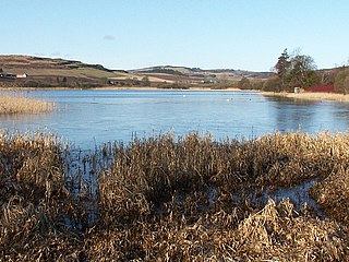
Lindores Loch is a freshwater loch, situated in North Fife in the Parish of Abdie, in the Central Belt of Scotland. The Loch has for many years been used as a fishery and is well known for its abundant fish life. A curling pond is situated on the Northern shoreline and is nominally used by the Abdie Curling Club and Abdie ladies Curling Club. A speculative study suggests that the loch was created by glacial deposits from the surrounding Ochil Hills at the end of the last ice-age. The water level and shoreline have changed over time due to roads, railway, sluice gate and farmland.
Balmacara Bay is a remote wide mouthed embayment on a 193° orientation, located on the north shore of the Lochalsh peninsula, on the north coast of sea loch of Loch Alsh and is situated next to the scattered village of Balmacara in the Scottish Highlands in the west coast of Scotland.

Loch of Butterstone is a small freshwater loch, almost circular in design, located within the nature reserve of the Cardney Estate, near Dunkeld in Perth and Kinross. It is one of a group of three lochs, which include Loch of the Lowes and Loch of Craiglush, which are located next to each other in southeast to northwest orientation. Loch of Butterstone is located at the top of the group at the northwest end, with Loch of the Lowes being at the southwest and Loch of Craiglush located north of Loch of the Lowes. The three lochs form a chain of lochs known as the Lunan Lochs.

Strachur Bay is a coastal embayment, on a 114° orientation, on the eastern coast of the longest sea loch in Scotland, Loch Fyne located in Argyll and Bute, on the west coast of Scotland. Strachur Bay provides good anchorage, for small vessels, when the wind is from the northeast and southeast.

Stormont Loch is a small irregular lowland freshwater loch, that is partially in-filled. It located in a nature reserve owned by the Scottish Wildlife Trust, on a north-east to south-west orientation and is 2 miles southeast of Blairgowrie in Perth and Kinross.
Long Loch is a small lowland freshwater loch within the Sidlaw Hills in Angus. It is 1.8 miles south of the village of Newtyle, three miles east-south-east of Coupar Angus and 2 miles directly north of Lundie. It is peculiar in shape, resembling a dog's body without legs and is on a north-east to south-west orientation.
Loch Hoil is a small freshwater lochan located between the shallow hills between Strath Braan and Strath Tay valley's in Perth and Kinross. Aberfeldy is located 4.0 miles (6.4 km) to the north.

